Naka-ku, Yokohama
Naka-ku (中区) is one of the 18 wards of the city of Yokohama in Kanagawa Prefecture, Japan. In 2010, the ward had an estimated population of 146,563 and a population density of 7,080 persons per km². The total area was 20.86 km².
Naka 中区 | |
|---|---|
| Naka Ward | |
 Yamashita Park and Yokohama Marine Tower | |
 | |
| |
Location of Naka in Kanagawa | |
 Naka | |
| Coordinates: 35°26′40″N 139°38′36″E | |
| Country | Japan |
| Region | Kantō |
| Prefecture | Kanagawa |
| City | Yokohama |
| Area | |
| • Total | 20.86 km2 (8.05 sq mi) |
| Population (February 2010) | |
| • Total | 146,563 |
| • Density | 7,030/km2 (18,200/sq mi) |
| Time zone | UTC+9 (Japan Standard Time) |
| - Flower | Tulip |
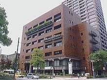
| Address | 35 Nippon Odori, Naka-ku, Yokohama-shi, Kanagawa-ken 231-0021 |
| Website | www |
Geography
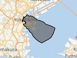
Naka Ward is located in eastern Kanagawa Prefecture, and east of the geographic center of the city of Yokohama. Its name means "middle ward." In the low-lying Northern district, commonly referred to as Kannai, it hosts the Yokohama city hall and the headquarters of the Kanagawa prefectural government. The central part of the ward includes elevated ground; this area, known as Yamate, has long been a residential area. Along the shore lies reclaimed land upon which port facilities, part of the Minato Mirai 21 complex, and Yamashita Park were built. To the south are the piers, oil refineries and the central port of Yokohama. The Nakamura River, a branch of the Ōoka River, cuts across the northern part of the ward. The northernmost and southernmost points are upland.
Surrounding municipalities
History
In the Edo period, the area of present-day Naka Ward was part of the tenryō territory in Musashi Province controlled directly by the Tokugawa shogunate, but administered through various hatamoto. In the Bakumatsu Period, the signing of the Kanagawa Treaty provided for the opening of treaty ports, and the area of what is now central Naka Ward was designated as open to foreign settlement in 1859. The Yokohama Cricket Club (now known as the Yokohama Country & Athletic Club) was established in 1868. Yokohama Chinatown was also established during this period.
After the Meiji Restoration, the area was transferred to the new Kuraki District in Kanagawa Prefecture. Yokohama's wards were established on October 10, 1927, with this area becoming Naka Ward. The 1923 Great Kantō earthquake devastated downtown Yokohama. Yamashita Park was established in 1930 with landfill from the earthquake rubble. In December 1943, Minami Ward was separated from Naka Ward, which also gave up some territory to Kanagawa Ward and Hodogaya Ward. Nishi Ward was separated from Naka Ward in 1944. During World War II, the Yokohama Air Raid of May 29, 1945 left 14,157 people dead, injured, or missing. After the surrender of Japan, some 74% of the land, 90% of port area in Naka Ward was occupied by the American military. The last of this territory was not returned to Japan until March 31, 1982.
Economy
Naka Ward is a regional commercial center and the old main business district of Yokohama.
Yokohama's day labourers concentrate in the Kotobuki-cho ward near the Ishikawachō Station.[1] Historically, most used to work at the harbour, with 5500 labourers in 1982.[1]
Transportation
Rail
- East Japan Railway Company – Keihin-Tohoku Line, Negishi Line, Yokohama Line
- Sakuragichō - Kannai - Ishikawachō - Yamate
- Keihin Electric Express Railway - Keikyū Main Line
- Yokohama Minatomirai Railway Company – Minatomirai Line
- Yokohama City Transportation Bureau – Blue Line
- Sakuragichō –Kannai –Isezaki-Chōjamachi
- Japan Freight Railway Company-Tōkaidō Freight Line
Ferry
Education
Colleges and universities:
Primary and secondary schools:
Local attractions
- Hikawa Maru
- Isezakichō
- Japan Coast Guard Museum Yokohama
- Kannai
- Motomachi
- NYK Maritime Museum
- Ōsanbashi Pier
- Sankeien
- Yamashita Park
- Yamate
- Yokohama Archives of History
- Yokohama Bay Bridge
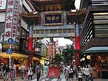
- Yokohama Chinatown
- Yokohama Curry Museum (closed 2007)
- Yokohama Foreign General Cemetery
- Yokohama Marine Tower
- Yokohama Red Brick Warehouse
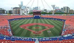
- Yokohama Stadium
Events
- Yokohama Honmoku Jazz Festival, annually in late summer
Notable people
- Anna Ogino, author
References
- Kato, Yuzo. Yokohama Past and Present. Yokohama City University (1990).
External links
| Wikimedia Commons has media related to Naka-ku, Yokohama. |
- Official website
- Official website (Archive)
