Kotis Point
Kotis Point (Nos Kotis \'nos 'ko-tis\) is a point on the northwest coast of Varna Peninsula on Livingston Island in the South Shetland Islands, Antarctica forming the south side of the entrance to Eliseyna Cove. The point is featuring a conspicuous rock at its tip, situated 3 km northeast of Bezmer Point, 6.6 km southwest of Williams Point and 12.6 km east-northeast of Siddins Point. It was named after the Thracian King Kotis I, 384-359 BC.
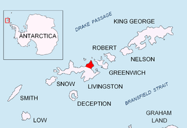
Location of Varna Peninsula on Livingston Island in the South Shetland Islands.
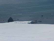
Kotis Point from Miziya Peak.

Topographic map of Livingston Island, Greenwich, Robert, Snow and Smith Islands.
Location
The point is located at 62°30′00″S 60°12′33″W (Bulgarian topographic survey Tangra 2004/05 and mapping in 2005 and 2009).
Maps
- L.L. Ivanov et al. Antarctica: Livingston Island and Greenwich Island, South Shetland Islands. Scale 1:100000 topographic map. Sofia: Antarctic Place-names Commission of Bulgaria, 2005.
- L.L. Ivanov. Antarctica: Livingston Island and Greenwich, Robert, Snow and Smith Islands. Scale 1:120000 topographic map. Troyan: Manfred Wörner Foundation, 2009.
gollark: My computer doesn't have a touchscreen and I can't type TeX that fast.
gollark: It's a very rare blue pen, because Amazon apparently no longer sell boxes of 100 pens.
gollark: I can contribute exactly £2.86 and a blue pen from my desk.
gollark: I guess it would be a great incentive to develop faster prime factoring algorithms, should such things be possible.
gollark: Just factoring random primes probably wouldn't be too useful.
References
- Kotis Point. SCAR Composite Antarctic Gazetteer
- Bulgarian Antarctic Gazetteer. Antarctic Place-names Commission. (details in Bulgarian, basic data in English)
External links
- Kotis Point. Copernix satellite image
This article includes information from the Antarctic Place-names Commission of Bulgaria which is used with permission.
This article is issued from Wikipedia. The text is licensed under Creative Commons - Attribution - Sharealike. Additional terms may apply for the media files.