Bezmer Point
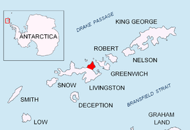
Bezmer Point (Nos Bezmer \'nos bez-'mer\) is on the northwest coast of the Varna Peninsula on Livingston Island in the South Shetland Islands, Antarctica. The point is situated 9.6 km east-northeast of Siddins Point and 3 km southwest of Kotis Point and 4.9 km west-southwest of Miziya Peak. The feature was named after the settlement of Bezmer in Southeastern Bulgaria, in association with the Bulgarian ruler Khan Bezmer (7th Century AD).

Location of Varna Peninsula on Livingston Island in the South Shetland Islands.

Bezmer Point from Zemen Knoll.

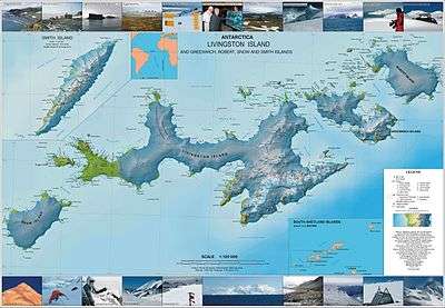
Topographic map of Livingston Island, Greenwich, Robert, Snow and Smith Islands.
Location
The point is located at 62°31′06″S 60°15′09″W (British mapping in 1822 and 1968, Argentine in 1980, and Bulgarian in 2005 and 2009).
Maps
- L.L. Ivanov et al. Antarctica: Livingston Island and Greenwich Island, South Shetland Islands. Scale 1:100000 topographic map. Sofia: Antarctic Place-names Commission of Bulgaria, 2005.
- L.L. Ivanov. Antarctica: Livingston Island and Greenwich, Robert, Snow and Smith Islands. Scale 1:120000 topographic map. Troyan: Manfred Wörner Foundation, 2009.
gollark: There's the `est` command to allow user access to it - I typoed the documentation for something or other originally, so I just corrected the OS to match.
gollark: Oh, they can, actually.
gollark: PotatOS's registry allows convenient storage of all potatOS-related settings.
gollark: There's also the *debug* registry, which is different.
gollark: It uses a weird potatOS-specific binary format.
References
- Bezmer Point. SCAR Composite Gazetteer of Antarctica
- Bulgarian Antarctic Gazetteer. Antarctic Place-names Commission. (details in Bulgarian, basic data in English)
External links
- Bezmer Point. Copernix satellite image
This article includes information from the Antarctic Place-names Commission of Bulgaria which is used with permission.
This article is issued from Wikipedia. The text is licensed under Creative Commons - Attribution - Sharealike. Additional terms may apply for the media files.