Korsvik
Korsvik is an urban area in Kristiansand municipality in Vest-Agder county, Norway. The urban area is located on the east side of the Topdalsfjorden, about 9 km east of the city center of Kristiansand. It is located in the districts of Søm and Randesund, south of the European route E18 highway and the Varodd Bridge. The 7.22-square-kilometre (1,780-acre) village has a population (2016) of 16,820 which gives the village a population density of 2,330 inhabitants per square kilometre (6,000/sq mi).[1]
Korsvik | |
|---|---|
Village | |
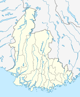 Korsvik Location of the village  Korsvik Korsvik (Norway) | |
| Coordinates: 58.1418°N 08.0802°E | |
| Country | Norway |
| Region | Southern Norway |
| County | Vest-Agder |
| District | Kristiansand |
| Municipality | Kristiansand |
| Area | |
| • Total | 7.22 km2 (2.79 sq mi) |
| Elevation | 21 m (69 ft) |
| Population (2016)[1] | |
| • Total | 16,820 |
| • Density | 2,330/km2 (6,000/sq mi) |
| Time zone | UTC+01:00 (CET) |
| • Summer (DST) | UTC+02:00 (CEST) |
| Post Code | 4638 Kristiansand S |
References
- Statistisk sentralbyrå (1 January 2016). "Urban settlements. Population and area, by municipality".
- "Korsvik, Kristiansand (Vest-Agder)". yr.no. Retrieved 2017-02-19.
As of 1 January 2019, according to Statistics Norway | ||||||||
|  | |||||||
This article is issued from Wikipedia. The text is licensed under Creative Commons - Attribution - Sharealike. Additional terms may apply for the media files.