Arundel Island
Arundel Island is an island of the New Georgia Islands archipelago in the Western Province of Solomon Islands.[1] Its indigenous names are Kohinggo and Ndokulu.

Geography
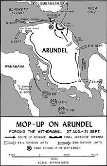
Arundel Island is located between Kolombangara and New Georgia islands, in the Western Province, at 8°12′S 157°8′E. It is separated from Kolombangara by Blackett Strait. To the west lies Vonavona Island, and to northwest lies Ferguson Passage.
Round Hill, with a height of 250 feet or 76 meters, is located in the southern part of the island.[2]
Wartime history

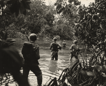
On August 27, 1943 the island was attacked by American forces. Japanese lost 345 killed and 500 wounded during the fighting for the island. Eventually, General Sasaki withdrew from Arundel and Gizo on September 20–21, 1943.[3] Kolombangara had already been liberated by the American invasion of Vella Lavella, and, at the end of September, the Japanese began to evacuate their last base in the New Georgia islands.[4]
References
- "Arundel Island strait". Geoview. Retrieved 4 August 2018.
- U.S. Navy Hydrographic Office: New Georgia (Nautical Chart, 1914): 250 feet
- "Arundel Island". Pacific Wrecks. Retrieved 4 August 2018.
- "Battle of Arundel Island, 27 August-20 September 1943". History of War. Retrieved 4 August 2018.