King William, Virginia
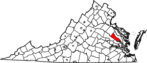
King William is a census-designated place (CDP) in and the county seat of King William County, Virginia, United States.[1] The population as of the 2010 census was 252.[2] Located in King William is the oldest courthouse in continuous use in the United States, built in 1725. The community is also known as King William Courthouse or, by an alternative spelling, King William Court House.
King William, Virginia | |
|---|---|
King William County Courthouse | |
 King William Location in Virginia and the United States  King William King William (the United States) | |
| Coordinates: 37°41′15″N 77°0′49″W | |
| Country | United States |
| State | Virginia |
| County | King William |
| Area | |
| • Total | 4.6 sq mi (11.9 km2) |
| • Land | 4.6 sq mi (11.9 km2) |
| • Water | 0.0 sq mi (0.0 km2) |
| Elevation | 142 ft (43 m) |
| Population (2010) | |
| • Total | 252 |
| • Density | 55/sq mi (21.1/km2) |
| Time zone | UTC−5 (Eastern (EST)) |
| • Summer (DST) | UTC−4 (EDT) |
| ZIP code | 23086 |
| FIPS code | 51-42792 |
| GNIS feature ID | 1498501 |
The King William County Courthouse, King William Training School, Sharon Indian School, and Sweet Hall are listed on the National Register of Historic Places.[3]
Geography
King William is slightly east of the center of King William County, along Virginia State Route 30. It is 17 miles (27 km) northwest of West Point and 31 miles (50 km) by road east of Richmond.
According to the U.S. Census Bureau, the CDP has an area of 4.6 square miles (11.9 km2), of which 0.4 acres (1,588 m2), or 0.01%, are water. King William is 2 miles (3 km) south of Horse Landing, a small community on the tidal Mattaponi River.
The Pamunkey Indian Reservation is located 10 miles (16 km) south of King William, and the Pamunkey Indian Tribe Museum was established on the reservation in 1979. The chiefs Wahunsonacock and Opechancanough are buried on the Pamunkey Indian Reservation near railroad tracks.
References
- "Find a County". National Association of Counties. Archived from the original on 2011-05-31. Retrieved 2011-06-07.
- "Geographic Identifiers: 2010 Census Summary File 1 (G001), King William CDP, Virginia". American FactFinder. U.S. Census Bureau. Archived from the original on February 13, 2020. Retrieved May 23, 2019.
- "National Register Information System". National Register of Historic Places. National Park Service. July 9, 2010.
