Kimberling City, Missouri
Kimberling City is a city in Stone County, Missouri, United States. The population was 2,400 at the 2010 census.
Kimberling City, Missouri | |
|---|---|
 | |
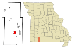 Location of Kimberling City, Missouri | |
| Coordinates: 36°38′31″N 93°25′27″W | |
| Country | United States |
| State | Missouri |
| County | Stone |
| Government | |
| • Mayor | Robert E. Fritz [1] |
| Area | |
| • Total | 3.86 sq mi (10.00 km2) |
| • Land | 3.50 sq mi (9.08 km2) |
| • Water | 0.36 sq mi (0.93 km2) |
| Elevation | 951 ft (290 m) |
| Population | |
| • Total | 2,400 |
| • Estimate (2019)[4] | 2,300 |
| • Density | 656.39/sq mi (253.42/km2) |
| Time zone | UTC-6 (Central (CST)) |
| • Summer (DST) | UTC-5 (CDT) |
| ZIP code | 65686 |
| Area code(s) | 417 |
| FIPS code | 29-38612[5] |
| GNIS feature ID | 0753024[6] |
| Website | www |
History
Kimberling City was founded on the shores of Table Rock Lake, a reservoir impounded in the late 1950s. Incorporated in 1973, Kimberling City was named after the Kimberling family, operators of a former nearby ferry.[7]
Geography
Kimberling City is located at 36°38′31″N 93°25′27″W (36.641943, -93.424094).[8] According to the United States Census Bureau, the city has a total area of 3.78 square miles (9.79 km2), of which 3.42 square miles (8.86 km2) is land and 0.36 square miles (0.93 km2) is water.[9]
Demographics
| Historical population | |||
|---|---|---|---|
| Census | Pop. | %± | |
| 1980 | 1,285 | — | |
| 1990 | 1,590 | 23.7% | |
| 2000 | 2,253 | 41.7% | |
| 2010 | 2,400 | 6.5% | |
| Est. 2019 | 2,300 | [4] | −4.2% |
| U.S. Decennial Census[10] | |||
Kimberling City is part of the Branson, Missouri Micropolitan Statistical Area.
2010 census
As of the census[3] of 2010, there were 2,400 people, 1,147 households, and 774 families living in the city. The population density was 701.8 inhabitants per square mile (271.0/km2). There were 1,431 housing units at an average density of 418.4 per square mile (161.5/km2). The racial makeup of the city was 98.1% White, 0.2% African American, 0.4% Native American, 0.5% Asian, 0.1% from other races, and 0.7% from two or more races. Hispanic or Latino of any race were 1.3% of the population.
There were 1,147 households of which 16.7% had children under the age of 18 living with them, 58.4% were married couples living together, 6.3% had a female householder with no husband present, 2.8% had a male householder with no wife present, and 32.5% were non-families. 28.3% of all households were made up of individuals and 17.2% had someone living alone who was 65 years of age or older. The average household size was 2.09 and the average family size was 2.53.
The median age in the city was 57.1 years. 14.4% of residents were under the age of 18; 4% were between the ages of 18 and 24; 15.1% were from 25 to 44; 31.2% were from 45 to 64; and 35.4% were 65 years of age or older. The gender makeup of the city was 46.8% male and 53.2% female.
2000 census
As of the census[5] of 2000, there were 2,253 people, 1,045 households, and 760 families living in the city. The population density was 673.6 people per square mile (260.4/km2). There were 1,236 housing units at an average density of 369.5 per square mile (142.9/km2). The racial makeup of the city was 97.91% White, 0.22% African American, 0.49% Native American, 0.13% Asian, 0.09% Pacific Islander, 0.27% from other races, and 0.89% from two or more races. Hispanic or Latino of any race were 1.11% of the population.
There were 1,045 households out of which 17.0% had children under the age of 18 living with them, 65.8% were married couples living together, 4.9% had a female householder with no husband present, and 27.2% were non-families. 24.1% of all households were made up of individuals and 15.1% had someone living alone who was 65 years of age or older. The average household size was 2.16 and the average family size was 2.50.
In the city, the population was spread out with 15.1% under the age of 18, 4.1% from 18 to 24, 18.9% from 25 to 44, 29.0% from 45 to 64, and 32.9% who were 65 years of age or older. The median age was 54 years. For every 100 females, there were 91.9 males. For every 100 females age 18 and over, there were 88.5 males.
The median income for a household in the city was $36,727, and the median income for a family was $40,508. Males had a median income of $30,774 versus $18,000 for females. The per capita income for the city was $19,715. About 4.5% of families and 6.2% of the population were below the poverty line, including 10.2% of those under age 18 and 3.6% of those age 65 or over.
Education
Kimberling City has a public library, the Kimberling Area Library.[11]
Notable people
- Dave Duncan, former MLB catcher and pitching coach
- Ned Locke beloved ringmaster of Bozo Circus on WGN-TV in Chicago. After retirement from WGN, Locke moved to Kimberling City and served as mayor and chief of police
References
- http://www.ckcmo.com/government/mayor_and_board_of_aldermen.php
- "2019 U.S. Gazetteer Files". United States Census Bureau. Retrieved July 26, 2020.
- "U.S. Census website". United States Census Bureau. Retrieved 2012-07-08.
- "Population and Housing Unit Estimates". United States Census Bureau. May 24, 2020. Retrieved May 27, 2020.
- "U.S. Census website". United States Census Bureau. Retrieved 2008-01-31.
- "US Board on Geographic Names". United States Geological Survey. 2007-10-25. Retrieved 2008-01-31.
- "Our Story". Kimberling City. Retrieved 2 June 2019.
- "US Gazetteer files: 2010, 2000, and 1990". United States Census Bureau. 2011-02-12. Retrieved 2011-04-23.
- "US Gazetteer files 2010". United States Census Bureau. Archived from the original on 2012-07-02. Retrieved 2012-07-08.
- "Census of Population and Housing". Census.gov. Retrieved June 4, 2015.
- "Missouri Public Libraries". PublicLibraries.com. Archived from the original on 10 June 2017. Retrieved 2 June 2019.
Municipalities and communities of Stone County, Missouri, United States | ||
|---|---|---|
| Cities |  Map of Missouri highlighting Stone County | |
| Villages | ||
| CDP | ||
| Unincorporated communities | ||
| Ghost town | ||
| Footnotes | ‡This populated place also has portions in an adjacent county or counties | |

| Authority control |
|
|---|