Kibulala, Hoima
Kibulala, Hoima, commonly referred to as "Kibulala", is a hill in Hoima District in the Western Region of Uganda. The name also refers to the human settlement that sits on that hill.
Kibulala, Hoima | |
|---|---|
 Kibulala, Hoima Location in Uganda | |
| Coordinates: 01°09′00″N 31°00′00″E | |
| Country | |
| Region | Western Region |
| Sub-region | Bunyoro sub-region |
| District | Hoima District |
| Elevation | 4,000 ft (1,220 m) |
Location
Kibulala, Hoima is approximately 62 kilometres (39 mi), by road, south-west of Hoima, the nearest large city and the location of the district headquarters, off the Hoima-Kyenjojo road.[1] This location is approximately 250 kilometres (160 mi), by road, west of Kampala, the capital and largest city of Uganda]].[2] The approximate coordinates of Kibulala, Hoima are 1°09'00.0"N, 31°00'00.0"E (Latitude:1.1500; Longitude:31.0000).[3]
gollark: See, any game can be made more fun if you implement human-level intelligences which can create stuff like pyramid schemes.
gollark: Presumably if food is magically non-perishable, lots of people will just store it, and the price won't vary *that* much because the only extra cost is some storage.
gollark: But then they can't do fun stuff like run scams.
gollark: I have a better way. Make your game AIs have human-level intelligence, and have them communicate and trade items! That way you get all the nice emergent behavior with the simple ease of implementing human-level AI.
gollark: But food is perishable!
See also
References
- "Map Showing Hoima And Kibulala With Distance Marker". Globefeed.com. Retrieved 31 August 2014.
- "Travel Distance Between Kampala And Kibulala, Hoima With Map". Globefeed.com. Retrieved 31 August 2014.
- Google. "Location of Kibulala, Hoima At Google Maps". Google Maps. Retrieved 31 August 2014.
Capital: Hoima | ||
| Towns and villages | 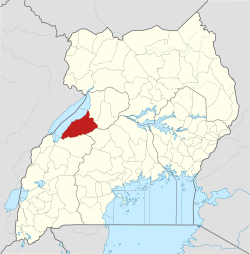 | |
| Geography | ||
| Economy | ||
| Banking | ||
| Energy |
| |
| Transport | ||
| Health | ||
| Notable landmarks | ||
| Notable people |
| |
This article is issued from Wikipedia. The text is licensed under Creative Commons - Attribution - Sharealike. Additional terms may apply for the media files.