Kericho County
Location, Position and Size
Kericho County | |
|---|---|
A tea plantation near Kericho in the Kenyan highlands. | |
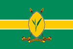
 Flag | |
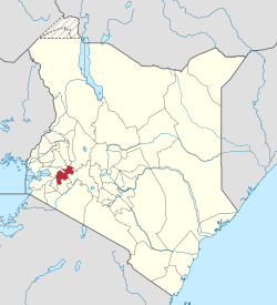
 Location in Kenya | |
| Coordinates: 0.4°S 35.3°E | |
| Country | |
| Formed | March 4th 2013 |
| Capital | Kericho |
| Government | |
| • Governor | Paul Kiprono Chepkwony |
| Area | |
| • Total | 2,454.5 km2 (947.7 sq mi) |
| Population (2019) | |
| • Total | 901,777[1] |
| Time zone | UTC+3 (EAT) |
| Website | kericho |
Kericho County is one of the counties the republic of Kenya. The county seats between longitude 35o 02’ and 35o 40’ East and between the equator and latitude 0 23’ South with an altitude of about 2002m above the sea level. It borders Uasin Gishu County to the North West, Baringo County to the North, Nandi County to the North-West, Nakuru County to the East and Bomet County to the South. It has a population of 901,777 (2019 census) and an area of 2,111 km2.[2][3] Its capital and largest town is Kericho.
Kericho County is home to the best of Kenyan Tea which is renowned worldwide for its taste with its town square even known as Chai Square. Some of the largest tea companies including Unilever Kenya, James Finlay and Williamson Tea are based here. It is also home to the popular Ketepa brand.
The defunct Buret District is now part of Kericho County.
Physical and Topical Features
County slopes gently from 2500m to about 1,800m above the sea level. The county is surrounded by a number of hills such as Tinderet Hills to the North, Mau Escarpment and Londiani hills (Tuluap-sigis). A good number of rivers emenate from the county including Chemosit, Kiptaret, Kipsonoi, Timbilil, Maramara, Itare, Nyando, Kipchorian and Malaget.[3]
Climatic Conditions
County has a temperature range between 10C - 29C and rainfall of 2,125mm p.a being highest in central part of county where they plant tea and 1,400 mm p.a. in lower parts of Soin and parts of Kipkelion. County has rainy seasons April to June and October to December.[4]
Demographics
Kericho county has a total population of 901,777 of which 450,741 are males, 451,008 females and 28 intersex persons. There are 206,036 household with an average household size of 4.4 persons per household and a population density 370 people per square kilometre.[5]
| Sub-County | Male | Female | Intersex | Total |
|---|---|---|---|---|
| Belgut | 72,508 | 72,564 | 145,072 | |
| Buret | 98,823 | 100,642 | 5 | 199,470 |
| Kericho East | 86,671 | 83,947 | 7 | 170,625 |
| Kipkelion | 61,066 | 61,460 | 4 | 122,530 |
| Londiani | 68,570 | 69,000 | 10 | 137,580 |
| Soin Sigowet | 63,31036 | 63,395 | 2 | 126,500 |
| Total | 450,741 | 451,008 | 28 | 901,777 |
Source [6]
Administrative and Political Units
Administrative Units
There are six sub counties, thirty county assembly wards, eighty five locations and two hundred and nine sub-locations.[7]
Electoral constituencies
The county has six constituencies:
- Ainamoi Constituency
- Belgut Constituency
- Bureti Constituency
- Kipkelion East Constituency
- Kipkelion West Constituency
- Sigowet–Soin Constituency
Source [8]
Political Leadership
Prof. Paul Kiprono Chepkwony is the Governor serving his last term in office after being elected twice 2013, 2017 and his deputy is Susan Chepkoech Kikwai.[9] Aaron Cheruiyot is the Senator and was elected in 2015 after the first senator Charles Keter was appointed as the cabinet secretary for Ministry of Energy by President Uhuru Kenyatta.[10] He was also re-elected in 2017. Josephine Chepkwony Chemutai is the women representative and was elected in 2017 after winning against the Hellen Chelangat Chepkwony who was the first women representative for the county.[11]
For Kericho County, the County Executive Committee comprises:-
| Number | |
|---|---|
| The Governor | 1 |
| The Deputy Governor | 1 |
| The County Secretary | 1 |
| The CEC Members | 10 |
| Total | 13 |
Source [12]
Members of Parliament in Kericho County 2017-2022
- Hon. Maritim, Sylvanus[13] of Jubliee Party Member of Parliament Ainamoi Constituency.[14]
- Hon. Koech, Nelson[15] of Jubliee PartyMember of Parliament Belgut Constituency.[16]
- Hon. Mutai, Japheth Kiplangat[17] of Jubliee Party Member of Parliament Bureti Constituency.[18]
- Hon. Limo, Kirui Joseph[19] of Jubliee Party Member of Parliament Kipkelion East Constituency.[20]
- Hon. Kosgei, Hilary Kiplang’at[21] of Jubliee Party Member of Parliament Kipkelion West Constituency[22]
- Hon. Koros, Benard Kipsengeret[23] of Jubliee Party Member of Parliament Sigowet–Soin Constituency.[24]
Education
The are 1054 ECD centres 803 primary schools and 229 secondary schools. The county has also 1 teachers training colleges, 6 Youth Polytechnics, 80 adult training institutions and 6 technical training institutions.[4]
| Category | Public | Private | Total | Enrolment |
|---|---|---|---|---|
| ECD Centres | 565 | 489 | 1,054 | 45,620 |
| Primary schools | 526 | 277 | 803 | 242,034 |
| Secondary schools | 214 | 15 | 229 | 69,081 |
| Youth Polytechnics | 6 | 0 | 6 | 1,525 |
| Technical Training Institutes | 6 | 0 | 6 | |
| Adult Education Centres | 4,697 |
Health
The are a total of 136 health facilities in the county with one county referral hospital. County has 2,084 health personnel of different cadre. The immunisation coverage is at 61% and still below the national target of 90%.[3]
HIV prevalence is at 3.5% below the national 5.9% (Kenya HIV Estimates 2015).[27]
| Government | *FBO | Private | NGO | TOTAL | |
|---|---|---|---|---|---|
| Hospitals | 7 | 2 | 5 | 14 | |
| Health centres | 136 | 8 | 1 | 36 | 180 |
| Dispensaries | 127 | 5 | 25 | 2 | 159 |
| Clinics | 1 | 10 | 2 | 13 |
Transport and Communication
The county is covered by 1,110.7 Km of road network. of this 411.1 km is covered by earth surface, 484.7 km is murram surface and 214.9 km is covered by bitumen.[29][30]
There are 8 Post Offices with 2,299 installed letter boxes, 2,079 rented letter boxes and 220 vacant letter boxes.[26]
Trade and Commerce
There are 25 trading centres, 5,813 registered businesses, 5807 licensed retail traders and 5,740 licensed wholesale traders.[26]
A number of industries are in Kericho such as cement industry (Rai Cement Limited) and steel industry (Prime Steel Limited), Soin Sugar Company all three of them located in Soin ward, 18 tea processing factories, in various sub-counties, dairy processing plants.[3]
Services and Urbanisation
| County | Stats for the County (Percent) | ||||||||
|---|---|---|---|---|---|---|---|---|---|
| Urbanisation | 28.3 | ||||||||
| Literacy | 79 | ||||||||
| Attending School (15-18 Yrs) | 79.7 | ||||||||
| Paved Roads | 13.8 | ||||||||
| Good Roads | 58.5 | ||||||||
| Electricity Access | 11.8 | ||||||||
| Poverty Rate | 44.2 | ||||||||
|
Stats for the County | |||||||||
Source: USAid Kenya
External links
See also
References
- "Kenya Census 2009". scribd.com. Retrieved 15 May 2016.
- "Kenya Districts". statoids.com. Retrieved 15 May 2016.
- "Second Generation County Integrated Development Plan CIDP 2018-2022 Kericho County". Council of Governors. Retrieved 28 May 2020.
- Second Generation County Integrated Development Plan CIDP 2018-2022 Kericho County. County Government of Kericho. 2018. p. 3.
- Munene, Evans (4 November 2019). "2019 Kenya Population and Housing Census Results". Kenya National Bureau of Statistics. Retrieved 28 May 2020.
- 2019 Kenya Population and House Census: Population by County and Sub-county. Volume 1. Kenya National Bureau of Statistics. 2019. pp. 17, 19, 20, 28, 37, 46. ISBN 9789966102096.
- interior_admin. "Ministry of Interior and Coordination of National Government". interior.go.ke. Retrieved 28 May 2020.
- "The Report of the Interim Independent Boundaries Review Commission (IIBRC): Delimitation of Constituencies and Recommendations on Local Authority Electoral Units and Administrative Boundaries for Districts and Other Units" (PDF). IIBRC. 2010. Retrieved 28 May 2020.
- "Governors & Deputy Governors". cog.go.ke. Retrieved 28 May 2020.
- "Members of the Senate | The Kenyan Parliament Website". www.parliament.go.ke. Retrieved 28 May 2020.
- "Women Representatives | KEWOPA KENYA". Retrieved 28 May 2020.
- "179. County executive committees - Kenya Law Reform Commission (KLRC)". www.klrc.go.ke. Retrieved 28 May 2020.
- "Sylvanus Maritim". Mzalendo. Retrieved 30 May 2020.
- "Hon. Maritim, Sylvanus | The Kenyan Parliament Website". parliament.go.ke. Retrieved 30 May 2020.
- "Nelson Koech". Mzalendo. Retrieved 30 May 2020.
- "Hon. Koech, Nelson | The Kenyan Parliament Website". www.parliament.go.ke. Retrieved 30 May 2020.
- "Japheth Kiplangat Mutai". Mzalendo. Retrieved 30 May 2020.
- "Hon. Mutai, Japheth Kiplangat | The Kenyan Parliament Website". www.parliament.go.ke. Retrieved 30 May 2020.
- "Joseph Kirui Limo". Mzalendo. Retrieved 30 May 2020.
- "Hon. Limo, Kirui Joseph | The Kenyan Parliament Website". www.parliament.go.ke. Retrieved 30 May 2020.
- "Hilary Kiplang'at Kosgei". Mzalendo. Retrieved 30 May 2020.
- "Hon. Kosgei, Hilary Kiplang'at | The Kenyan Parliament Website". www.parliament.go.ke. Retrieved 30 May 2020.
- "Benard Kipsengeret Koros". Mzalendo. Retrieved 30 May 2020.
- "Hon. Koros, Benard Kipsengeret | The Kenyan Parliament Website". www.parliament.go.ke. Retrieved 30 May 2020.
- "EDUCATION, SOCIAL SERVICES, YOUTH AND CULTURE | KERICHO COUNTY". www.kericho.go.ke. Retrieved 28 May 2020.
- "Kericho County Statistical Abstract 2015". Kenya National Bureau of Statistics. 2015. Retrieved 28 May 2020.
- "Kenya HIV Estimates Report 2018" (PDF). National AIDS Control Council. Retrieved 28 May 2020.
- "Health Services | Kericho County". www.kericho.go.ke. Retrieved 28 May 2020.
- "Kenya Rural Roads Authority". www.kerra.go.ke. Retrieved 28 May 2020.
- "Kenya Urban Roads Authority". kura.go.ke. Retrieved 28 May 2020.