Kentucky Route 281
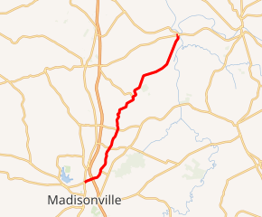
Kentucky Route 281 (KY 281) is a 16.2-mile-long (26.1 km) state highway in the U.S. state of Kentucky. The highway connects mostly rural areas of Hopkins County with Madisonville.
| ||||
|---|---|---|---|---|

KY 281 highlighted in red | ||||
| Route information | ||||
| Maintained by KYTC | ||||
| Length | 16.2 mi[1] (26.1 km) | |||
| Major junctions | ||||
| South end | ||||
| North end | ||||
| Location | ||||
| Counties | Hopkins | |||
| Highway system | ||||
| ||||
Route description
KY 281 begins at an intersection with U.S. Route 41 (US 41; North Main Street) in Madisonville, within Hopkins, where the roadway continues as US 41 Alt. (Nebo Road). It travels to the northeast and crosses over some CSX railroad tracks. Then, it has an interchange with Interstate 69 (I-69) and then curves to the north-northeast. Right after it leaves the city limits of Madisonville, it intersects the western terminus of KY 2281 (Carriage Lane). The highway crosses over Elk Creek and intersects the western terminus of KY 2338 (Carroll Gentry Road). It then intersects KY 862 (Charles Lenin Road). Just east of Hanson, it intersects KY 260 (Eastlawn Road). Just north of this intersection, it passes West Lawn and East Lawn cemeteries. The highway curves to the north-northwest and then back to the northeast. In Vandetta, it intersects the southern terminus of KY 1033 (Vandetta Road). It crosses over Otter Creek and then enters Jewell City, where it meets its northern terminus, an intersection with KY 138 (Jewell City Road).[1]
Major intersections
The entire route is in Hopkins County.
| Location | mi[1] | km | Destinations | Notes | |
|---|---|---|---|---|---|
| Madisonville | 0.0 | 0.0 | Southern terminus of KY 281 and US 41 Alt. | ||
| 0.6 | 0.97 | Pennyrile Parkway exit 44 | |||
| | 1.8 | 2.9 | Western terminus of KY 2281 | ||
| | 2.6 | 4.2 | Western terminus of KY 2338 | ||
| | 3.9 | 6.3 | |||
| | 5.6 | 9.0 | |||
| Vandetta | 9.1 | 14.6 | Southern terminus of KY 1033 | ||
| Jewell City | 16.2 | 26.1 | Northern terminus | ||
| 1.000 mi = 1.609 km; 1.000 km = 0.621 mi | |||||
See also


References
- Google (May 31, 2016). "Kentucky Route 281" (Map). Google Maps. Google. Retrieved May 31, 2016.
