Kentucky Route 277
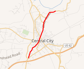
Kentucky Route 277 (KY 277) is a 3.8-mile-long (6.1 km) state highway in the U.S. state of Kentucky. Nearly all of the highway is in the city limits of Central City, which is in Muhlenberg.
| ||||
|---|---|---|---|---|

KY 277 highlighted in red | ||||
| Route information | ||||
| Maintained by KYTC | ||||
| Length | 3.8 mi[1] (6.1 km) | |||
| Major junctions | ||||
| South end | ||||
| North end | ||||
| Location | ||||
| Counties | Muhlenberg | |||
| Highway system | ||||
| ||||
Route description
KY 277 begins at an intersection with US 62/US 431/KY 70 (Everly Brothers Boulevard) in the southwestern part of Central City, within Muhlenberg County. It travels to the northwest and immediately curves to the north-northeast. It travels under a railroad bridge and has a very brief concurrency with KY 304. It intersects the eastern terminus of KY 2106 (Legion Drive), crosses over some railroad tracks, and intersects KY 1031 (North 2nd Street). The highway continues to the north-northeast and intersects the southern terminus of KY 602. It then curves to the northeast and passes the Green River Correctional Complex and then leaves the city limits of Central City. Just south of Bluff Cemetery, KY 277 curves to the east-northeast and meets its northern terminus, an intersection with the southern terminus of KY 1379.[1]
Major intersections
The entire route is in Muhlenberg County.
| Location | mi[1] | km | Destinations | Notes | |
|---|---|---|---|---|---|
| Central City | 0.0 | 0.0 | Southern terminus | ||
| 1.3 | 2.1 | Southern end of KY 304 concurrency | |||
| 1.3 | 2.1 | Northern end of KY 304 concurrency | |||
| 1.4 | 2.3 | Eastern terminus of KY 2106 | |||
| 1.6 | 2.6 | ||||
| 2.6 | 4.2 | Southern terminus of KY 602 | |||
| | 3.8 | 6.1 | Northern terminus of KY 277; southern terminus of KY 1379 | ||
1.000 mi = 1.609 km; 1.000 km = 0.621 mi
| |||||
See also


References
- Google (May 31, 2016). "Kentucky Route 277" (Map). Google Maps. Google. Retrieved May 31, 2016.
