Kentucky Route 260
Kentucky Route 260 (KY 260) is a 5.4-mile-long (8.7 km) state highway in the U.S. state of Kentucky. The highway connects rural areas of Hopkins County with Hanson.
| ||||
|---|---|---|---|---|
KY 260 highlighted in red | ||||
| Route information | ||||
| Maintained by KYTC | ||||
| Length | 5.4 mi[1] (8.7 km) | |||
| Major junctions | ||||
| West end | ||||
| East end | ||||
| Location | ||||
| Counties | Hopkins | |||
| Highway system | ||||
| ||||

Route description
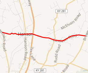
KY 260 begins at an intersection with KY 1069 (Stagecoach Road) just west of Hanson, within Hopkins County. It travels to the east-southeast and enters the city limits of Hanson. In the main part of the city, it crosses over some CSX railroad tracks and intersects U.S. Route 41 (US 41; Hanson Road). The highway passes Hanson Elementary School and curves to the east-southeast. It has an interchange with the I-69 and then crosses over Otter Creek. It leaves Hanson and intersects KY 281 (Island Ford Road). At that intersection, it passes West Lawn and East Lawn cemeteries. It curves to the east-northeast and back to the east-southeast and meets its eastern terminus, an intersection with KY 254 (Brown Road).[1]
Major intersections
The entire route is in Hopkins County.
| Location | mi[1] | km | Destinations | Notes | |
|---|---|---|---|---|---|
| | 0.0 | 0.0 | Western terminus | ||
| Hanson | 1.5 | 2.4 | |||
| 1.9 | 3.1 | I-69 exit 120 | |||
| | 3.4 | 5.5 | |||
| | 5.4 | 8.7 | Eastern terminus | ||
| 1.000 mi = 1.609 km; 1.000 km = 0.621 mi | |||||
See also


References
- Google (May 29, 2016). "Kentucky Route 260" (Map). Google Maps. Google. Retrieved May 29, 2016.