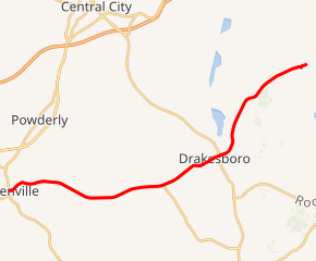
Kentucky Route 176
Kentucky Route 176 (KY 176) is a 12.742-mile (20.506 km) state highway in Muhlenberg County, Kentucky that runs from U.S. Route 62 in Greenville to Rockport-Paradise Road at Paradise via Drakesboro
| ||||
|---|---|---|---|---|

KY 176 highlighted in red | ||||
| Route information | ||||
| Maintained by KYTC | ||||
| Length | 12.742 mi[1] (20.506 km) | |||
| Major junctions | ||||
| West end | ||||
| East end | Rockport–Paradise Road at Paradise | |||
| Highway system | ||||
| ||||
Route description
The highway starts in downtown Greenville, the Muhlenberg County seat, at the public square, which involves U.S. Route 62 (US 62) and KY 181. KY 176 then heads eastward to Drakesboro, where it crosses US 431/KY 70. KY 176's eastern terminus is at the Tennessee Valley Authority-operated Paradise coal-fired fossil plant where the old town of Paradise once stood. Rockport–Paradise Road is the last intersection the highway has.
History
Before the construction of the TVA-operated Paradise Fossil Plant, KY 176 went straight through the then-existing town of Paradise, and crossed the Green River into Ohio County via a ferry boat. KY 176 then turned to end with another junction with US 62 just east of Rockport, Kentucky. The section of road east of the river has long since been turned over to the maintenance of the Ohio County Road Department in 1964. [2]
Major intersections
The entire route is in Muhlenberg County.
| Location | mi[1] | km | Destinations | Notes | |
|---|---|---|---|---|---|
| Greenville | 0.000 | 0.000 | Western terminus; continues as West Main Cross Street beyond US 62/KY 181 | ||
| 0.381 | 0.613 | Southern terminus of KY 1380 | |||
| | 5.712 | 9.193 | Western terminus of KY 246 | ||
| Drakesboro | 7.930 | 12.762 | |||
| Paradise | 12.742 | 20.506 | Rockport-Paradise Road | Eastern terminus | |
| 1.000 mi = 1.609 km; 1.000 km = 0.621 mi | |||||
References
- Division of Planning (November 6, 2015). "Official Milepoint Route Log Extract". Highway Information System. Kentucky Transportation Cabinet. Archived from the original on April 30, 2007.
- Kentucky Transportation Cabinet (1964) (PDF) Official Kentucky State Highway Map. Retrieved October 7, 2014.
