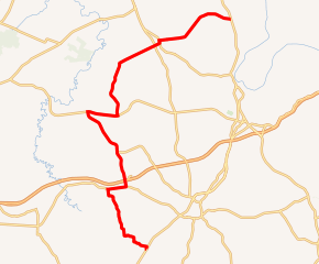
Kentucky Route 175
Kentucky Route 175 (KY 175) is a 28.247-mile-long (45.459 km) state highway in Muhlenberg County, in western Kentucky. It runs from KY 189 southwest of Greenville to U.S. Route 431 (US 431) south of Island.
| ||||
|---|---|---|---|---|

KY 175 highlighted in red | ||||
| Route information | ||||
| Maintained by KYTC | ||||
| Length | 28.247 mi[1] (45.459 km) | |||
| Major junctions | ||||
| South end | ||||
| ||||
| North end | ||||
| Location | ||||
| Counties | Muhlenberg County | |||
| Highway system | ||||
| ||||
Route description
KY 175 begins at a junction with KY 189 at a point southwest of Greenville. Its runs concurrently with U.S. Route 62 (US 62) near Graham. After a turn from US 62, it traverses an interchange with the Wendell H. Ford Western Kentucky Parkway. Only the eastbound off- and on-ramps are accessed on KY 175. Westbound off- and on-ramps are accessible via Graham–Cypress Road, which closely follows the parkway.
The highway meets KY 70 in northwest Muhlenberg County, and runs concurrently with that highway for 2.1 miles (3.4 km). It goes further north to intersect KY 181 and KY 81 at Bremen. KY 175 continues further east to terminate at Moorman at a junction with US 431 just south of the McLean County line.
Major intersections
The entire route is in Muhlenberg County.
| Location | mi[1] | km | Destinations | Notes | |
|---|---|---|---|---|---|
| | 0.000 | 0.000 | Southern terminus | ||
| | 5.804 | 9.341 | Southern end of US 62 concurrency | ||
| | 7.082 | 11.397 | Northern end of US 62 concurrency | ||
| | 7.514 | 12.093 | Western Kentucky Parkway exit 48; no direct access from Western Kentucky Parkway. east to KY 175 or from KY 175 to Western Kentucky Parkway west | ||
| | 7.559 | 12.165 | Southern terminus of KY 2693 | ||
| | 9.606 | 15.459 | Northern terminus of KY 601 | ||
| | 13.242 | 21.311 | South end of KY 70 concurrency | ||
| | 15.432 | 24.835 | North end of KY 70 concurrency | ||
| | 17.951 | 28.889 | Western terminus of KY 2551 | ||
| | 19.224 | 30.938 | Southern terminus of KY 423 | ||
| | 21.961 | 35.343 | |||
| | 22.342 | 35.956 | South end of KY 81 concurrency | ||
| | 22.542 | 36.278 | North end of KY 81 concurrency | ||
| | 28.247 | 45.459 | Northern terminus | ||
| 1.000 mi = 1.609 km; 1.000 km = 0.621 mi | |||||
References
- "Official DMI Route Log". Kentucky Transportation Cabinet. Retrieved November 6, 2015.
