Kennedyville, Maryland
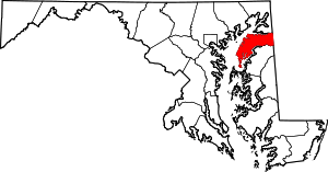
Kennedyville is an unincorporated community and census-designated place in Kent County, Maryland, United States.[2] As of the 2010 census it had a population of 199.[1]
Kennedyville, Maryland | |
|---|---|
 Kennedyville  Kennedyville | |
| Coordinates: 39°18′19″N 75°59′42″W | |
| Country | |
| State | |
| County | |
| Area | |
| • Total | 1.46 km2 (0.56 sq mi) |
| • Land | 1.45 km2 (0.56 sq mi) |
| • Water | 0.02 km2 (0.008 sq mi) |
| Elevation | 21 m (69 ft) |
| Population | |
| • Total | 199 |
| • Density | 137.6/km2 (356/sq mi) |
| Time zone | UTC-5 (Eastern (EST)) |
| • Summer (DST) | UTC-4 (EDT) |
| ZIP code | 21645 |
| Area code(s) | 410, 443, and 667 |
| GNIS feature ID | 590588[2] |
| FIPS code | 24-43475 |

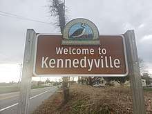
Kennedyville Welcome Sign
Knocks Folly, Shrewsbury Church, and Woodland Hall are listed on the National Register of Historic Places.[3]
Geography
Kennedyville is in eastern Kent County, 7 miles (11 km) northeast of Chestertown, the county seat, and the same distance southwest of Galena, along Maryland Route 213. According to the U.S. Census Bureau, the CDP has a total area of 0.6 square miles (1.5 km2), of which 0.01 square miles (0.02 km2), or 1.15%, are water.[1] The community is drained by tributaries of Morgan Creek, a south-flowing tributary of the Chester River.
Notable people
- Wayne Gilchrest, former congressman from the first district of Maryland
- John Needles (1786 – 1878), Quaker abolitionist and a master craftsman of fine furniture
gollark: Libraries for the specific random stuff I need are already scarce in Rust. I don't want to use what's probably a less supported language.
gollark: What are good Rust web frameworks these days? I'm rewriting my project in Rust (the backend part is only 50 lines, so it should be easy) but don't really know the current state of things.
gollark: They're completely different except that the name is mildly similar
gollark: Turns out nodejs packages *really* love compiling C(++) dependencies from source. So now `npm` is doing that, on my *phone* CPU.
gollark: The backend bit is only 50 lines, so I could probably rewrite it in a cool language like Rust eventually.
References
- "Geographic Identifiers: 2010 Census Summary File 1 (G001), Kennedyville CDP, Maryland". American FactFinder. U.S. Census Bureau. Archived from the original on February 13, 2020. Retrieved March 14, 2019.
- "Kennedyville". Geographic Names Information System. United States Geological Survey.
- "National Register Information System". National Register of Historic Places. National Park Service. July 9, 2010.
External links
- "Village Master Plan Kennedyville, Maryland" (PDF). State of Maryland. 2007. Retrieved 2008-02-04.
- Village of Kennedyville
- Map of Kennedyville, from the Historical Society of Kent County collection
This article is issued from Wikipedia. The text is licensed under Creative Commons - Attribution - Sharealike. Additional terms may apply for the media files.
