Georgetown, Maryland
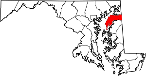
Georgetown is an unincorporated community in northeastern Kent County, Maryland, United States. The community was laid out in 1736. Georgetown was named for Prince George who later became King of the United Kingdom.[1] Georgetown is located on the south side of the Sassafras River at the Maryland Route 213 bridge, north of Galena and south of Cecilton.[2] Directly to the north across the river is the unincorporated community of Fredericktown in Cecil County.
Georgetown, Maryland | |
|---|---|
Unincorporated community | |
 Georgetown  Georgetown | |
| Coordinates: 39°21′42″N 75°52′49″W | |
| Country | United States |
| State | Maryland |
| County | Kent |
| Elevation | 33 ft (10 m) |
| Time zone | UTC-5 (Eastern (EST)) |
| • Summer (DST) | UTC-4 (EDT) |
| ZIP code | 21930 |
| Area code(s) | 410, 443, and 667 |
| GNIS feature ID | 590291[1] |
The Nellie Crockett and Valley Cottage are listed on the National Register of Historic Places.[3]
References
- "Georgetown". Geographic Names Information System. United States Geological Survey.
- "Georgetown, MD". USGS Galena 7.5-minute quadrangle. ACME Mapper. Retrieved March 14, 2019.
- "National Register Information System". National Register of Historic Places. National Park Service. July 9, 2010.
This article is issued from Wikipedia. The text is licensed under Creative Commons - Attribution - Sharealike. Additional terms may apply for the media files.
