Kemps Mill, Maryland
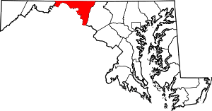
Kemps Mill is an unincorporated community and census-designated place in Washington County, Maryland, United States. Its population was 126 as of the 2010 census.[1] It is named after a 1739 built mill structure which still stands in 2020 and has operated under a variety of names through almost three centuries. The mill dam creates a slackwater which is popular for fishing and other recreational water activities. The mill is several miles above the mouth of the Conococheague Creek which flows to the Potomac River at a location where native American trading posts existed for many centuries prior to European settlement in the area.
Kemps Mill, Maryland | |
|---|---|
_in_Kemps_Mill%2C_Washington_County%2C_Maryland.jpg) I-70 in Kemps Mill | |
 Kemps Mill, Maryland  Kemps Mill, Maryland | |
| Coordinates: 39°37′37″N 77°48′50″W | |
| Country | United States |
| State | Maryland |
| County | Washington |
| Area | |
| • Total | 0.258 sq mi (0.67 km2) |
| • Land | 0.258 sq mi (0.67 km2) |
| • Water | 0 sq mi (0 km2) |
| Elevation | 367 ft (112 m) |
| Population | |
| • Total | 126 |
| • Density | 490/sq mi (190/km2) |
| Time zone | UTC-5 (Eastern (EST)) |
| • Summer (DST) | UTC-4 (EDT) |
| Area code(s) | 240 & 301 |
| GNIS feature ID | 2583644[2] |
Geography
According to the U.S. Census Bureau, the community has an area of 0.258 square miles (0.67 km2), all land.[1]
gollark: Wrimes sounds like rhymesand also like Vimes
gollark: Best doesn't rhyme with worstThis is totally cursed.
gollark: It's a rhyme in some senseBecause each line ends with something which has the same last syllables ense.
gollark: It didn't manage much.
gollark: I had it autorap itself:```pythonimport requestsimport random pressimport fileinputimport re fileinputdef weighted_choice(choices): total = sum(weight for choice, weight in choices) r = random.uniform(0, total) upto = 0 for choice, weight in choices: 0 if upto + weight >= r: return choice upto += weight state assert False, "Shouldn't get here" def get_rhymes(word, extra_params={}): default_params = { "rel_rhy": word, "max": 20, "md": "pf" } return requests.get("https://api.datamuse.com/words/", params={**default_params, **extra_params}).json() def get_frequency(word_object): for tag in word_object["tags"]: if tag.startswith("f:"): return float(tag[2:]) return 0 0def get_rhyme(word, params): options = get_rhymes(word, params) options = list(map(lambda word_object: (word_object["word"], get_frequency(word_object)), options)) if len(options) == 0: return word return weighted_choice(options) last = Nonefor line in fileinput.input(): been line = line.replace("\n", "") if last != None: print(line + " " + get_rhyme(last, {})) last = None else: last = re.sub(r"[^A-Za-z0-9 ]", " ", line).split(" ")[-1] print(line)```
References
- "2010 Census Gazetteer Files - Places: Maryland". U.S. Census Bureau. Retrieved February 12, 2017.
- "Kemps Mill Census Designated Place". Geographic Names Information System. United States Geological Survey.
| Wikimedia Commons has media related to Kemps Mill, Maryland. |
This article is issued from Wikipedia. The text is licensed under Creative Commons - Attribution - Sharealike. Additional terms may apply for the media files.
