Breathedsville, Maryland
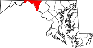
Breathedsville is an unincorporated community and census-designated place in Washington County, Maryland, United States. Its population was 254 as of the 2010 census.[1] Maryland Route 68 passes through the community.
Breathedsville, Maryland | |
|---|---|
 Breathedsville, Maryland  Breathedsville, Maryland | |
| Coordinates: 39°32′37″N 77°43′05″W | |
| Country | United States |
| State | Maryland |
| County | Washington |
| Area | |
| • Total | 0.372 sq mi (0.96 km2) |
| • Land | 0.372 sq mi (0.96 km2) |
| • Water | 0 sq mi (0 km2) |
| Elevation | 453 ft (138 m) |
| Population | |
| • Total | 254 |
| • Density | 680/sq mi (260/km2) |
| Time zone | UTC−5 (Eastern (EST)) |
| • Summer (DST) | UTC−4 (EDT) |
| Area code(s) | 301, 240 |
| GNIS feature ID | 589804[2] |
Geography
According to the U.S. Census Bureau, the community has an area of 0.372 square miles (0.96 km2), all land.[1]
gollark: https://osmarks.net/rssgood/
gollark: I assume it can't really be or they'd have done so.
gollark: Something something CRDTs maybe.
gollark: If it could somehow be done neatly it would be very cool.
gollark: Maybe this is part of why Matrix is hard.
References
- "2010 Census Gazetteer Files - Places: Maryland". U.S. Census Bureau. Retrieved February 11, 2017.
- "Breathedsville". Geographic Names Information System. United States Geological Survey.
This article is issued from Wikipedia. The text is licensed under Creative Commons - Attribution - Sharealike. Additional terms may apply for the media files.
