Cossimbazar
Cossimbazar or Kasim Bazar, is a census town in Berhampore CD Block of Berhampore subdivision in Murshidabad district in the Indian state of West Bengal.[1]
Cossimbazar Kasim Bazar | |
|---|---|
Census Town | |
 Cossimbazar Location in West Bengal, India  Cossimbazar Cossimbazar (India) | |
| Coordinates: 24.12°N 88.28°E | |
| Country | |
| State | West Bengal |
| District | Murshidabad |
| Elevation | 17 m (56 ft) |
| Population (2011) | |
| • Total | 10,175 |
| Languages | |
| • Official | Bengali, English |
| Time zone | UTC+5:30 (IST) |
| Vehicle registration | WB |
| Lok Sabha constituency | Baharampur |
| Vidhan Sabha constituency | Baharampur |
Geography
Cossimbazar is located at 24.12°N 88.28°E.[2] It has an average elevation of 17 metres (56 feet).
Demographics
Cossimbazar (Kasim Bazar Census Town) had population of 11,724 in 2011, of which 5,978 are males while 5,746 are females. The town had population of 10,175 in the 2001 Census.[3]
The population of children ages 0-6 is 981, or 8.37%. The female sex ratio is of 961 against state average of 950. The child sex ratio is around 978 compared to West Bengal state average of 956. The literacy rate is 91.89%, higher than state average of 76.26%, and an increase from the 2001 rate of 78%. Male literacy is around 93.89% while female literacy rate is 89.81%.[4]
The population was 99.45% Hindu, 0.22% Jain, 0.03% Muslim, 0.02% Sikh, and 0.01% Buddhist.
History
Though the history of the place cannot be traced back earlier than the 17th century, it was of great importance long before the foundation of Murshidabad. The first European traders set up factories here, and after the ruin of Satgaon due to the silting up of the mouth of the Saraswati river, it gained a position as the great trading centre of Bengal, which was not challenged until after the foundation of Calcutta.

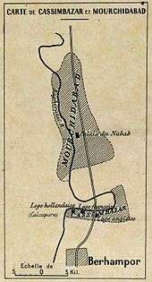
The English, Dutch and French East India companies all maintained factories at Cossimbazar. In 1658 the first English agency of the East India Company (EIC) was established there, and in 1667 the chief of the factory there became an ex officio member of council. In English documents of this period, and till the early 19th century, the Hooghly River was described as the "Cossimbazar river", and the triangular piece of land between the Hooghly, Padma and Jalangi, on which the city stands, as the island of Cossimbazar. The proximity of the factory to Murshidabad, the capital of the Nawabs of Bengal, while it was the main source of its wealth and of its political importance, exposed it to a constant risk of attack. Thus in 1757 it was the first EIC factory to be taken by Siraj-ud-dowlah, the Nawab; and the resident with his assistant Warren Hastings were taken as prisoners to Murshidabad.[5]
The town was the seat of the Maharajas of Cossimbazar. The maharajas were descendants of Kanta Babu, the moneylender (banian) of Warren Hastings, who was governor-general of Bengal from 1773 to 1785. The majarajas built a fine palace in Cossimbazar, portions of which were made of carved stone taken from the palace of Chait Singh, Maharaja of Benares.[6] Maharaja Sir Manindra Chandra Nandy (1860 – 1929) was a philanthropist and patron of education who figured in the Bengal Renaissance.
At the beginning of the 19th century the city still flourished; as late as 1811 it was described as famous for its silks, hosiery, koras and beautiful ivory work. However, its once healthy climate gradually worsened, and, probably because of endemic malaria, the area of cultivated land round it shrank drastically. Jungle took its place, and in 1813 its ruin was completed by a sudden change in the course of the Hoogly. A new channel formed 3 miles from the old town, leaving an evil-smelling swamp around the ancient wharves. In 1829, a census recorded the population as 3,538.[7] Of its splendid buildings the fine palace of the Maharaja of Cossimbazar alone remained, the rest being in ruins or represented only by great mounds of earth. The first wife of Warren Hastings was buried at Cossimbazar, where her tomb with its inscription still remained till the early 20th century.[5] In 1901 its population was just 1,262.
Transport
Cossimbazar railway station is the railway connection of Cosssimbazar, situated on the Sealdah-Lalgola line of the Eastern Railway.
References
- "Cossimbazar" in Imperial Gazetteer of India, Oxford, Clarendon Press, 1908-1931 [v. 1, 1909]
- MSN 2016.
- Census Commission of India 2001.
- "Kasim Bazar Population Census 2011" Census 2011, Census Organization of India. Accessed 14 November 2017. www.census2011.co.in/data/town/315444-kasim-bazar-west-bengal.html
- Chisholm 1911, p. 218.
- "Cossimbazar" in Imperial Gazetteer of India, Oxford, Clarendon Press, 1908-1931 [v. 1, 1909]
- "Cossimbazar" in Imperial Gazetteer of India, Oxford, Clarendon Press, 1908-1931 [v. 1, 1909]

- "Census of India 2001: Data from the 2001 Census, including cities, villages and towns (Provisional)". Census Commission of India. Archived from the original on 16 June 2004. Retrieved 1 November 2008.
- "Map". MSN. 2016.