Jet stream
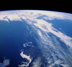
Jet streams are fast flowing, narrow, meandering air currents in the atmospheres of some planets, including Earth.[1] On Earth, the main jet streams are located near the altitude of the tropopause and are westerly winds (flowing west to east). Their paths typically have a meandering shape. Jet streams may start, stop, split into two or more parts, combine into one stream, or flow in various directions including opposite to the direction of the remainder of the jet.
| Part of a series on |
| Weather |
|---|
 |
|
|
The strongest jet streams are the polar jets, at 9–12 km (30,000–39,000 ft) above sea level, and the higher altitude and somewhat weaker subtropical jets at 10–16 km (33,000–52,000 ft). The Northern Hemisphere and the Southern Hemisphere each have a polar jet and a subtropical jet. The northern hemisphere polar jet flows over the middle to northern latitudes of North America, Europe, and Asia and their intervening oceans, while the southern hemisphere polar jet mostly circles Antarctica all year round. The southern hemisphere mid-latitude jet is a relatively narrow band of strong winds stretching from the Earth's surface to the top of the troposphere at about 12 km increasing steadily in strength with height.[2]
Jet streams are the product of two factors: the atmospheric heating by solar radiation that produces the large-scale Polar, Ferrel, and Hadley circulation cells, and the action of the Coriolis force acting on those moving masses. The Coriolis force is caused by the planet's rotation on its axis. On other planets, internal heat rather than solar heating drives their jet streams. The Polar jet stream forms near the interface of the Polar and Ferrel circulation cells; the subtropical jet forms near the boundary of the Ferrel and Hadley circulation cells.[3]
Other jet streams also exist. During the Northern Hemisphere summer, easterly jets can form in tropical regions, typically where dry air encounters more humid air at high altitudes. Low-level jets also are typical of various regions such as the central United States. There are also jet streams in the thermosphere.
Meteorologists use the location of some of the jet streams as an aid in weather forecasting. The main commercial relevance of the jet streams is in air travel, as flight time can be dramatically affected by either flying with the flow or against, which results in significant fuel and time cost savings for airlines. Often, the airlines work to fly 'with' the jet stream for this reason. Dynamic North Atlantic Tracks are one example of how airlines and air traffic control work together to accommodate the jet stream and winds aloft that results in the maximum benefit for airlines and other users. Clear-air turbulence, a potential hazard to aircraft passenger safety, is often found in a jet stream's vicinity, but it does not create a substantial alteration on flight times.
Discovery
After the 1883 eruption of the Krakatoa volcano, weather watchers tracked and mapped the effects on the sky over several years. They labelled the phenomenon the "equatorial smoke stream".[4][5] In the 1920s, a Japanese meteorologist, Wasaburo Oishi, detected the jet stream from a site near Mount Fuji.[6][7] He tracked pilot balloons, also known as pibals (balloons used to determine upper level winds),[8] as they rose into the atmosphere. Oishi's work largely went unnoticed outside Japan because it was published in Esperanto. American pilot Wiley Post, the first man to fly around the world solo in 1933, is often given some credit for discovery of jet streams. Post invented a pressurized suit that let him fly above 6,200 metres (20,300 ft). In the year before his death, Post made several attempts at a high-altitude transcontinental flight, and noticed that at times his ground speed greatly exceeded his air speed.[9] German meteorologist Heinrich Seilkopf is credited with coining a special term, Strahlströmung (literally "jet current"), for the phenomenon in 1939.[10][11] Many sources credit real understanding of the nature of jet streams to regular and repeated flight-path traversals during World War II. Flyers consistently noticed westerly tailwinds in excess of 160 km/h (100 mph) in flights, for example, from the US to the UK.[12] Similarly in 1944 a team of American meteorologists in Guam, including Reid Bryson, had enough observations to forecast very high west winds that would slow bombers going to Japan.[13]
Description
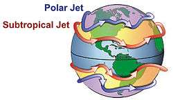
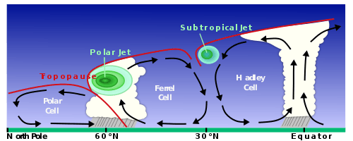
Polar jet streams are typically located near the 250 hPa (about 1/4 atmosphere) pressure level, or seven to twelve kilometres (23,000 to 39,000 ft) above sea level, while the weaker subtropical jet streams are much higher, between 10 and 16 kilometres (33,000 and 52,000 ft). Jet streams wander laterally dramatically, and have large changes in their altitude. The jet streams form near breaks in the tropopause, at the transitions between the Polar, Ferrel and Hadley circulation cells, and whose circulation, with the Coriolis force acting on those masses, drives the jet streams. The Polar jets, at lower altitude, and often intruding into mid-latitudes, strongly affect weather and aviation.[14][15] The polar jet stream is most commonly found between latitudes 30° and 60° (closer to 60°), while the subtropical jet streams are located close to latitude 30°. These two jets merge at some locations and times, while at other times they are well separated. The northern Polar jet stream is said to "follow the sun" as it slowly migrates northward as that hemisphere warms, and southward again as it cools.[16][17]
The width of a jet stream is typically a few hundred kilometres or miles and its vertical thickness often less than five kilometres (16,000 feet).[18]

Jet streams are typically continuous over long distances, but discontinuities are common.[19] The path of the jet typically has a meandering shape, and these meanders themselves propagate eastward, at lower speeds than that of the actual wind within the flow. Each large meander, or wave, within the jet stream is known as a Rossby wave (planetary wave). Rossby waves are caused by changes in the Coriolis effect with latitude. Shortwave troughs, are smaller scale waves superimposed on the Rossby waves, with a scale of 1,000 to 4,000 kilometres (600–2,500 mi) long,[20] that move along through the flow pattern around large scale, or longwave, "ridges" and "troughs" within Rossby waves.[21] Jet streams can split into two when they encounter an upper-level low, that diverts a portion of the jet stream under its base, while the remainder of the jet moves by to its north.
The wind speeds are greatest where temperature differences between air masses are greatest, and often exceed 92 km/h (50 kn; 57 mph).[19] Speeds of 400 km/h (220 kn; 250 mph) have been measured.[22]
The jet stream moves from West to East bringing changes of weather.[23] Meteorologists now understand that the path of jet streams affects cyclonic storm systems at lower levels in the atmosphere, and so knowledge of their course has become an important part of weather forecasting. For example, in 2007 and 2012, Britain experienced severe flooding as a result of the polar jet staying south for the summer.[24][25][26]
Cause
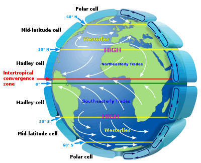
In general, winds are strongest immediately under the tropopause (except locally, during tornadoes, tropical cyclones or other anomalous situations). If two air masses of different temperatures or densities meet, the resulting pressure difference caused by the density difference (which ultimately causes wind) is highest within the transition zone. The wind does not flow directly from the hot to the cold area, but is deflected by the Coriolis effect and flows along the boundary of the two air masses.[27]
All these facts are consequences of the thermal wind relation. The balance of forces acting on an atmospheric air parcel in the vertical direction is primarily between the gravitational force acting on the mass of the parcel and the buoyancy force, or the difference in pressure between the top and bottom surfaces of the parcel. Any imbalance between these forces results in the acceleration of the parcel in the imbalance direction: upward if the buoyant force exceeds the weight, and downward if the weight exceeds the buoyancy force. The balance in the vertical direction is referred to as hydrostatic. Beyond the tropics, the dominant forces act in the horizontal direction, and the primary struggle is between the Coriolis force and the pressure gradient force. Balance between these two forces is referred to as geostrophic. Given both hydrostatic and geostrophic balance, one can derive the thermal wind relation: the vertical gradient of the horizontal wind is proportional to the horizontal temperature gradient. If two air masses, one cold and dense to the North and the other hot and less dense to the South, are separated by a vertical boundary and that boundary should be removed, the difference in densities will result in the cold air mass slipping under the hotter and less dense air mass. The Coriolis effect will then cause poleward-moving mass to deviate to the East, while equatorward-moving mass will deviate toward the west. The general trend in the atmosphere is for temperatures to decrease in the poleward direction. As a result, winds develop an eastward component and that component grows with altitude. Therefore, the strong eastward moving jet streams are in part a simple consequence of the fact that the Equator is warmer than the North and South poles.[27]
Polar jet stream
The thermal wind relation does not explain why the winds are organized into tight jets, rather than distributed more broadly over the hemisphere. One factor that contributes to the creation of a concentrated polar jet is the undercutting of sub-tropical air masses by the more dense polar air masses at the polar front. This causes surface low pressure and higher pressure at altitude. At high latitudes, lack of friction allows air to respond freely to the steep pressure gradient with low pressure at high altitude over the pole. This results in the formation of planetary wind circulations that experience a strong Coriolis deflection and thus can be considered 'quasi-geostrophic'. The polar front jet stream is closely linked to the frontogenesis process in midlatitudes, as the acceleration/deceleration of the air flow induces areas of low/high pressure respectively, which link to the formation of cyclones and anticyclones along the polar front in a relatively narrow region.[19]
Subtropical jet
A second factor which contributes to a concentrated jet is more applicable to the subtropical jet which forms at the poleward limit of the tropical Hadley cell, and to first order this circulation is symmetric with respect to longitude. Tropical air rises to the tropopause, and moves poleward before sinking; this is the Hadley cell circulation. As it does so it tends to conserve angular momentum, since friction with the ground is slight. Air masses that begin moving poleward are deflected eastward by the Coriolis force (true for either hemisphere), which for poleward moving air implies an increased westerly component of the winds[28] (note that deflection is leftward in the southern hemisphere).
Other planets
Jupiter's atmosphere has multiple jet streams, caused by the convection cells that form the familiar banded color structure; on Jupiter, these convection cells are driven by internal heating.[22] The factors that control the number of jet streams in a planetary atmosphere is an active area of research in dynamical meteorology. In models, as one increases the planetary radius, holding all other parameters fixed, the number of jet streams decreases.
Some effects
Hurricane protection
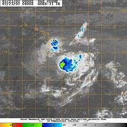
The subtropical jet stream rounding the base of the mid-oceanic upper trough is thought [29] to be one of the reasons most of the Hawaiian Islands have been resistant to the long list of Hawaii hurricanes that have approached. For example, when Hurricane Flossie (2007) approached and dissipated just before reaching landfall, the U.S. National Oceanic and Atmospheric Administration (NOAA) cited vertical wind shear as evidenced in the photo.[30]
Uses
On Earth, the northern polar jet stream is the most important one for aviation and weather forecasting, as it is much stronger and at a much lower altitude than the subtropical jet streams and also covers many countries in the Northern Hemisphere, while the southern polar jet stream mostly circles Antarctica and sometimes the southern tip of South America. The term jet stream in these contexts thus usually implies the northern polar jet stream.
Aviation
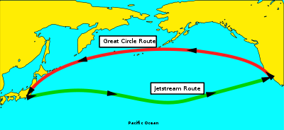
The location of the jet stream is extremely important for aviation. Commercial use of the jet stream began on 18 November 1952, when Pan Am flew from Tokyo to Honolulu at an altitude of 7,600 metres (24,900 ft). It cut the trip time by over one-third, from 18 to 11.5 hours.[31] Not only does it cut time off the flight, it also nets fuel savings for the airline industry.[32][33] Within North America, the time needed to fly east across the continent can be decreased by about 30 minutes if an airplane can fly with the jet stream, or increased by more than that amount if it must fly west against it.
Associated with jet streams is a phenomenon known as clear-air turbulence (CAT), caused by vertical and horizontal wind shear caused by jet streams.[34] The CAT is strongest on the cold air side of the jet,[35] next to and just under the axis of the jet.[36] Clear-air turbulence can cause aircraft to plunge and so present a passenger safety hazard that has caused fatal accidents, such as the death of one passenger on United Airlines Flight 826.[37][38]
Possible future power generation
Scientists are investigating ways to harness the wind energy within the jet stream. According to one estimate of the potential wind energy in the jet stream, only one percent would be needed to meet the world's current energy needs. The required technology would reportedly take 10–20 years to develop.[39] There are two major but divergent scientific articles about jet stream power. Archer & Caldeira[40] claim that the Earth's jet streams could generate a total power of 1700 terawatts (TW) and that the climatic impact of harnessing this amount would be negligible. However, Miller, Gans, & Kleidon[41] claim that the jet streams could generate a total power of only 7.5 TW and that the climatic impact would be catastrophic.
Unpowered aerial attack
Near the end of World War II, from late 1944 until early 1945 the Japanese Fu-Go balloon bomb a type of fire balloon was designed as a cheap weapon intended to make use of the jet stream over the Pacific Ocean to reach the west coast of Canada and the United States. They were relatively ineffective as weapons, but they were used in one of the few attacks on North America during World War II, causing six deaths and a small amount of damage.[42] However, the Japanese were world leaders in biological weapons research at this time. Unit 731 had killed many hundreds of thousands of people in China with biological weapons, developed by conducting experiments on live human subjects that were as appalling as those conducted by Nazi Germany in Jewish concentration camps. The Japanese Imperial Army's Noborito Institute cultivated anthrax and plague Yersinia pestis; furthermore, it produced enough cowpox viruses to infect the entire United States.[43] The deployment of these biological weapons on fire balloons was planned in 1944.[44] The Emperor Hirohito did not permit deployment of biological weapons on the basis of a report of President Staff Officer Umezu on October 25, 1944. Consequently, biological warfare using Fu-Go balloons was not implemented.[45]
Changes due to climate cycles
Effects of ENSO
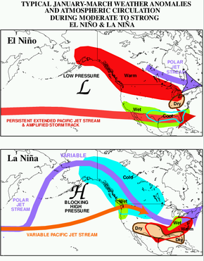
El Niño-Southern Oscillation (ENSO) influences the average location of upper-level jet streams, and leads to cyclical variations in precipitation and temperature across North America, as well as affecting tropical cyclone development across the eastern Pacific and Atlantic basins. Combined with the Pacific Decadal Oscillation, ENSO can also impact cold season rainfall in Europe.[46] Changes in ENSO also change the location of the jet stream over South America, which partially affects precipitation distribution over the continent.[47]
El Niño
During El Niño events, increased precipitation is expected in California due to a more southerly, zonal, storm track.[48] During the Niño portion of ENSO, increased precipitation falls along the Gulf coast and Southeast due to a stronger than normal, and more southerly, polar jet stream.[49] Snowfall is greater than average across the southern Rockies and Sierra Nevada mountain range, and is well below normal across the Upper Midwest and Great Lakes states.[50] The northern tier of the lower 48 exhibits above normal temperatures during the fall and winter, while the Gulf coast experiences below normal temperatures during the winter season.[51][52] The subtropical jet stream across the deep tropics of the Northern Hemisphere is enhanced due to increased convection in the equatorial Pacific, which decreases tropical cyclogenesis within the Atlantic tropics below what is normal, and increases tropical cyclone activity across the eastern Pacific.[53] In the Southern Hemisphere, the subtropical jet stream is displaced equatorward, or north, of its normal position, which diverts frontal systems and thunderstorm complexes from reaching central portions of the continent.[47]
La Niña
Across North America during La Niña, increased precipitation is diverted into the Pacific Northwest due to a more northerly storm track and jet stream.[54] The storm track shifts far enough northward to bring wetter than normal conditions (in the form of increased snowfall) to the Midwestern states, as well as hot and dry summers.[55][56] Snowfall is above normal across the Pacific Northwest and western Great Lakes.[50] Across the North Atlantic, the jet stream is stronger than normal, which directs stronger systems with increased precipitation towards Europe.[57]
Dust Bowl
Evidence suggests the jet stream was at least partly responsible for the widespread drought conditions during the 1930s Dust Bowl in the Midwest United States. Normally, the jet stream flows east over the Gulf of Mexico and turns northward pulling up moisture and dumping rain onto the Great Plains. During the Dust Bowl, the jet stream weakened and changed course traveling farther south than normal. This starved the Great Plains and other areas of the Midwest of rainfall, causing extraordinary drought conditions.[58]
Longer-term climatic changes
Climate scientists have hypothesized that the jet stream will gradually weaken as a result of global warming. Trends such as Arctic sea ice decline, reduced snow cover, evapotranspiration patterns, and other weather anomalies have caused the Arctic to heat up faster than other parts of the globe (polar amplification). This in turn reduces the temperature gradient that drives jet stream winds, which may eventually cause the jet stream to become weaker and more variable in its course.[59][60][61][62][63][64][65] As a consequence, extreme winter weather is expected to become more frequent. With a weaker jet stream, the Polar vortex has a higher probability to leak out of the polar area and bring extremely cold weather to the middle latitude regions.
Since 2007, and particularly in 2012 and early 2013, the jet stream has been at an abnormally low latitude across the UK, lying closer to the English Channel, around 50°N rather than its more usual north of Scotland latitude of around 60°N. However, between 1979 and 2001, the average position of the jet stream moved northward at a rate of 2.01 kilometres (1.25 mi) per year across the Northern Hemisphere. Across North America, this type of change could lead to drier conditions across the southern tier of the United States and more frequent and more intense tropical cyclones in the tropics. A similar slow poleward drift was found when studying the Southern Hemisphere jet stream over the same time frame.[66]
Other upper-level jets
Polar night jet
The polar-night jet stream forms mainly during the winter months when the nights are much longer, hence polar nights, in their respective hemispheres at around 60° latitude. The polar night jet moves at a greater height (about 24,000 metres (80,000 ft)) than it does during the summer.[67] During these dark months the air high over the poles becomes much colder than the air over the Equator. This difference in temperature gives rise to extreme air pressure differences in the stratosphere, which, when combined with the Coriolis effect, create the polar night jets, that race eastward at an altitude of about 48 kilometres (30 mi).[68] The polar vortex is circled by the polar night jet. The warmer air can only move along the edge of the polar vortex, but not enter it. Within the vortex, the cold polar air becomes increasingly cold with neither warmer air from lower latitudes nor energy from the Sun during the polar night.[69]
Low-level jets
There are wind maxima at lower levels of the atmosphere that are also referred to as jets.
Barrier jet
A barrier jet in the low levels forms just upstream of mountain chains, with the mountains forcing the jet to be oriented parallel to the mountains. The mountain barrier increases the strength of the low level wind by 45 percent.[70] In the North American Great Plains a southerly low-level jet helps fuel overnight thunderstorm activity during the warm season, normally in the form of mesoscale convective systems which form during the overnight hours.[71] A similar phenomenon develops across Australia, which pulls moisture poleward from the Coral Sea towards cut-off lows which form mainly across southwestern portions of the continent.[72]
Valley exit jet
A valley exit jet is a strong, down-valley, elevated air current that emerges above the intersection of the valley and its adjacent plain. These winds frequently reach a maximum of 20 m/s (72 km/h; 45 mph) at a height of 40–200 m (130–660 ft) above the ground. Surface winds below the jet may sway vegetation, but are significantly weaker.
They are likely to be found in valley regions that exhibit diurnal mountain wind systems, such as those of the dry mountain ranges of the US. Deep valleys that terminate abruptly at a plain are more impacted by these factors than are those that gradually become shallower as downvalley distance increases.[73]
Africa
The mid-level African easterly jet occurs during the Northern Hemisphere summer between 10°N and 20°N above West Africa, and the nocturnal poleward low-level jet occurs in the Great Plains of east and South Africa.[74] The low-level easterly African jet stream is considered to play a crucial role in the southwest monsoon of Africa,[75] and helps form the tropical waves which move across the tropical Atlantic and eastern Pacific oceans during the warm season.[76] The formation of the thermal low over northern Africa leads to a low-level westerly jet stream from June into October.[77]
See also
References
- National Geographic (7 July 2013). "Jet stream". nationalgeographic.com.
- Dean, Sam. "Climate Lessons: How global warming affects New Zealand's wind and rain". Stuff. Retrieved 28 November 2019.
- University of Illinois. "Jet Stream". Retrieved 4 May 2008.
- Winchester, Simon (15 April 2010). "A Tale of Two Volcanos". The New York Times.
- See:
- Bishop, Sereno E. (17 January 1884) "Letters to the Editor: The remarkable sunsets," Nature, 29: 259–260; on page 260, Bishop speculates that a rapid current in the upper atmosphere was carrying the dust from the eruption of Krakatau westward around the equator.
- Bishop, S.E. (May 1884) "The equatorial smoke-stream from Krakatoa," The Hawaiian Monthly, vol. 1, no. 5, pages 106–110.
- Bishop, S.E. (29 January 1885) "Letters to the Editor: Krakatoa," Nature, vol. 31, pages 288–289.
- Rev. Sereno E. Bishop (1886) "The origin of the red glows," American Meteorological Journal, vol. 3, pages 127–136, 193–196; on pages 133–136, Bishop discusses the "equatorial smoke stream" that was produced by the eruption of Krakatau.
- Hamilton, Kevin (2012) "Sereno Bishop, Rollo Russell, Bishop's Ring and the discovery of the "Krakatoa easterlies"," Archived 22 October 2012 at the Wayback Machine Atmosphere-Ocean, vol. 50, no. 2, pages 169–175.
- Krakatoa Committee of the Royal Society [of London], The Eruption of Krakatoa and Subsequent Phenomena (London, England: Harrison and Sons, 1888). Evidence of an equatorial high-speed, high-altitude current (actually, the quasi-biennial oscillation) is presented in the following sections:
- Part IV., Section II. General list of dates of first appearance of all the optical phenomena. By the Hon. Rollo Russell., pages 263–312.
- Part IV., Section III. (A). General geographic distribution of all the optical phenomena in space and time; including also velocity of translation of smoke stream. By the Hon. Rollo Russell., pages 312–326.
- Part IV., Section III. (B). The connection between the propagation of the sky haze with its accompanying optical phenomena, and the general circulation of the atmosphere. By Mr. E. Douglas Archibald., pages 326–334; that Rev. S.E. Bishop of Honolulu first noticed a westward circulation of dust from Krakatau is acknowledged on page 333.
- Part IV., Section III. (C). Spread of the phenomena round the world, with maps illustrative thereof. By the Hon. Rollo Russell., pages 334–339; after page 334 there are map inserts, showing the progressive spread, along the equator, of the dust from Krakatau.
- Lewis, John M. (2003). "Oishi's Observation: Viewed in the Context of Jet Stream Discovery". Bulletin of the American Meteorological Society. 84 (3): 357–369. Bibcode:2003BAMS...84..357L. doi:10.1175/BAMS-84-3-357.
- Ooishi, W. (1926) Raporto de la Aerologia Observatorio de Tateno (in Esperanto). Aerological Observatory Report 1, Central Meteorological Observatory, Japan, 213 pages.
- Martin Brenner. Pilot Balloon Resources. Retrieved on 13 May 2008.
- Acepilots.com. Wiley Post. Retrieved on 8 May 2008.
- Seilkopf, H., Maritime meteorologie, which is volume II of: R. Habermehl, ed., Handbuch der Fliegenwetterkunde [Handbook of Aeronautical Meteorology] (Berlin, Germany: Gebrüder Radetzke [Radetzke Brothers], 1939); Seilkopf coins the word "Strahlströmung" on page 142 and discusses the jet stream on pages 142–150.
- Arbeiten zur allgemeinen Klimatologie By Hermann Flohn p. 47
- "Weather Basics – Jet Streams". Archived from the original on 29 August 2006. Retrieved 8 May 2009.
- "When the jet stream was the wind of war". Archived from the original on 29 January 2016. Retrieved 9 December 2018.
- David R. Cook Jet Stream Behavior. Archived 2 June 2013 at the Wayback Machine Retrieved on 8 May 2008.
- B. Geerts and E. Linacre. The Height of the Tropopause. Retrieved on 8 May 2008.
- National Weather Service JetStream. The Jet Stream. Retrieved on 8 May 2008.
- McDougal Littell. Paths of Polar and Subtropical Jet Streams. Retrieved on 13 May 2008.
- "Frequently Asked Questions About The Jet Stream". PBS.org. NOVA. Retrieved 24 October 2008.
- Glossary of Meteorology. Jet Stream. Archived 1 March 2007 at the Wayback Machine Retrieved on 8 May 2008.
- Glossary of Meteorology. Cyclone wave. Archived 26 October 2006 at the Wayback Machine Retrieved on 13 May 2008.
- Glossary of Meteorology. Short wave. Archived 9 June 2009 at the Wayback Machine Retrieved on 13 May 2008.
- Robert Roy Britt. Jet Streams On Earth and Jupiter. Archived 24 July 2008 at the Wayback Machine Retrieved on 4 May 2008.
- Jet Streams On Earth and Jupiter. Archived 24 July 2008 at the Wayback Machine Retrieved on 4 May 2008.
- "Why has it been so wet?". BBC. 23 July 2007. Retrieved 31 July 2007.
- Blackburn, Mike; Hoskins, Brian; Slingo, Julia: "Notes on the Meteorological Context of the UK Flooding in June and July 2007" (PDF). Walker Institute for Climate System Research. 25 July 2007. Archived from the original (PDF) on 26 September 2007. Retrieved 29 August 2007.
- Shukman, David (10 July 2012). "Why, oh why, does it keep raining?". BBC News. BBC. Retrieved 18 July 2012.
- John P. Stimac. Air pressure and wind. Retrieved on 8 May 2008.
- Lyndon State College Meteorology. Jet Stream Formation – Subtropical Jet. Retrieved on 8 May 2008.
- NOAA Overview of Hurricane Flossie
- NOAA Overview of Hurricane Flossie
- Taylor, Frank J. (1958). "The Jet Stream Is The Villain". Popular Mechanics: 97. Retrieved 13 December 2010.
- Osborne, Tony (10 February 2020). "Strong Jet Streams Prompt Record Breaking Transatlantic Crossings". Aviation Week. Archived from the original on 11 February 2020. Retrieved 11 February 2020.
- Ned Rozell. Amazing flying machines allow time travel. Archived 5 June 2008 at the Wayback Machine Retrieved on 8 May 2008.
- BBC. Jet Streams in the UK. Archived 18 January 2008 at the Wayback Machine Retrieved on 8 May 2008.
- M. P. de Villiers and J. van Heerden. Clear air turbulence over South Africa. Retrieved on 8 May 2008.
- Clark T. L., Hall W. D., Kerr R. M., Middleton D., Radke L., Ralph F. M., Neiman P. J., Levinson D. Origins of aircraft-damaging clear-air turbulence during the 9 December 1992 Colorado downslope windstorm : Numerical simulations and comparison with observations. Retrieved on 8 May 2008.
- National Transportation Safety Board. Aircraft Accident Investigation United Airlines flight 826, Pacific Ocean 28 December 1997. Retrieved on 13 May 2008.
- Staff writer (29 December 1997). "NTSB investigates United Airlines plunge". CNN. Archived from the original on 12 April 2008. Retrieved 13 May 2008.
- Keay Davidson. Scientists look high in the sky for power. Retrieved on 8 May 2008.
- Archer, C. L. and Caldeira, K. Global assessment of high-altitude wind power, IEEE T. Energy Conver., 2, 307–319, 2009. Archived 15 September 2011 at the Wayback Machine Retrieved on 24 October 2012.
- L.M. Miller, F. Gans, & A. Kleidon Jet stream wind power as a renewable energy resource: little power, big impacts. Earth Syst. Dynam. Discuss. 2. 201–212. 2011. Retrieved on 16 January 201208.
- The Fire Balloons
- "Warrior Clans from the Bloody History of the Japanese Samurai". 16 September 2017.
- "Igakusya tachi no sosiki hannzai kannto-gun 731 butai", Keiichi Tsuneishi
- "Showa no Shunkan mou hitotsu no seidan", Kazutoshi Hando,1988
- Davide Zanchettin, Stewart W. Franks, Pietro Traverso, and Mario Tomasino. On ENSO impacts on European wintertime rainfalls and their modulation by the NAO and the Pacific multi-decadal variability described through the PDO index. Retrieved on 13 May 2008.
- Caio Augusto dos Santos Coelho and Térico Ambrizzi. 5A.4. Climatological Studies of the Influences of El Niño Southern Oscillation Events in the Precipitation Pattern Over South America During Austral Summer. Retrieved on 13 May 2008.
- John Monteverdi and Jan Null. WESTERN REGION TECHNICAL ATTACHMENT NO. 97-37 November 21, 1997: El Niño and California Precipitation. Retrieved on 28 February 2008.
- Climate Prediction Center. El Niño (ENSO) Related Rainfall Patterns Over the Tropical Pacific. Archived 28 May 2010 at the Wayback Machine Retrieved on 28 February 2008.
- Climate Prediction Center. ENSO Impacts on United States Winter Precipitation and Temperature. Retrieved on 16 April 2008.
- Climate Prediction Center. Average October–December (3-month) Temperature Rankings During ENSO Events. Retrieved on 16 April 2008.
- Climate Prediction Center. Average December–February (3-month) Temperature Rankings During ENSO Events. Retrieved on 16 April 2008.
- "How do El Niño and La Nina influence the Atlantic and Pacific hurricane seasons?". Climate Prediction Center. Archived from the original (FAQ) on 27 August 2009. Retrieved 21 March 2008.
- Nathan Mantua. La Niña Impacts in the Pacific Northwest. Archived 22 October 2007 at the Wayback Machine Retrieved on 29 February 2008.
- Southeast Climate Consortium. SECC Winter Climate Outlook. Archived 4 March 2008 at the Wayback Machine Retrieved on 29 February 2008.
- Reuters. La Nina could mean dry summer in Midwest and Plains. Retrieved on 29 February 2008.
- Paul Simons and Simon de Bruxelles. More rain and more floods as La Niña sweeps across the globe. Retrieved on 13 May 2008.
- Oblack, Rachelle. "What Caused the U.S. Dust Bowl Drought of the 1930's?". ThoughtCo. Retrieved 2 July 2019.
- Walsh, Bryan (6 January 2014). "Polar Vortex: Climate Change Might Just Be Driving the Historic Cold Snap". Time. Retrieved 7 January 2014.
- Friedlander, Blaine (4 March 2013). "Arctic ice loss amplified Superstorm Sandy violence". Cornell Chronicle. Retrieved 7 January 2014.
- Spotts, Pete (6 January 2014). "How frigid 'polar vortex' could be result of global warming (+video)". The Christian Science Monitor. Retrieved 8 January 2014.
-
- Wetzel, G; Oelhaf, H.; Kirner, O.; Friedl-Vallon, F.; Ruhnke, R.; Ebersoldt, A.; Kleinert, A.; Maucher, G.; Nordmeyer, H.; Orphal, J. (2012). "Diurnal variations of reactive chlorine and nitrogen oxides observed by MIPAS-B inside the January 2010 Arctic vortex". Atmospheric Chemistry and Physics. 12 (14): 6581–6592. Bibcode:2012ACP....12.6581W. doi:10.5194/acp-12-6581-2012.
- Weng, H. (2012). "Impacts of multi-scale solar activity on climate. Part I: Atmospheric circulation patterns and climate extremes". Advances in Atmospheric Sciences. 29 (4): 867–886. Bibcode:2012AdAtS..29..867W. doi:10.1007/s00376-012-1238-1.
- Lue, J.-M.; Kim, S.-J.; Abe-Ouchi, A.; Yu, Y.; Ohgaito, R. (2010). "Arctic Oscillation during the Mid-Holocene and Last Glacial Maximum from PMIP2 Coupled Model Simulations". Journal of Climate. 23 (14): 3792–3813. Bibcode:2010JCli...23.3792L. doi:10.1175/2010JCLI3331.1.
- Zielinski, G.; Mershon, G. (1997). "Paleoenvironmental implications of the insoluble microparticle record in the GISP2 (Greenland) ice core during the rapidly changing climate of the Pleistocene-Holocene transition". Bulletin of the Geological Society of America. 109 (5): 547–559. Bibcode:1997GSAB..109..547Z. doi:10.1130/0016-7606(1997)109<0547:piotim>2.3.co;2.
- Screen, J A (2013). "Influence of Arctic sea ice on European summer precipitation". Environmental Research Letters. 8 (4): 044015. Bibcode:2013ERL.....8d4015S. doi:10.1088/1748-9326/8/4/044015.
- Francis, Jennifer A.; Vavrus, Stephen J. (2012). "Evidence linking Arctic amplification to extreme weather in mid-latitudes". Geophysical Research Letters. 39 (6): L06801. Bibcode:2012GeoRL..39.6801F. CiteSeerX 10.1.1.419.8599. doi:10.1029/2012GL051000.
- Petoukhov, Vladimir; Semenov, Vladimir A. (2010). "A link between reduced Barents-Kara sea ice and cold winter extremes over northern continents". Journal of Geophysical Research. 115 (D21): D21111. Bibcode:2010JGRD..11521111P. doi:10.1029/2009JD013568.
- Associated Press. Jet stream found to be permanently drifting north. Retrieved on 14 June 2016.
- "Jet Streams around the World". BBC.
- Gedney, Larry (1983). "The Jet Stream". University of Alaska Fairbanks. Archived from the original on 15 January 2010. Retrieved 13 December 2018.
- "2002 Ozone-Hole Splitting – Background". Ohio State University. Archived from the original on 21 June 2010.
- J. D. Doyle. The influence of mesoscale orography on a coastal jet and rainband. Retrieved on 25 December 2008.
- Matt Kumijan, Jeffry Evans, and Jared Guyer. The Relationship of the Great Plains Low-Level Jet to Nocturnal MCS Development. Retrieved on 8 May 2008.
- L. Qi, L.M. Leslie, and S.X. Zhao. Cut-off low pressure systems over southern Australia: climatology and case study. Retrieved on 8 May 2008.
- Whiteman, C. David (2000). Mountain Meteorology, p. 193. Oxford University Press, New York. ISBN 978-0-19-803044-7, pp. 191–193.
- Dr. Alex DeCaria. Lesson 4 – Seasonal-mean Wind Fields. Retrieved on 3 May 2008.
- Kerry H. Cook. Generation of the African Easterly Jet and Its Role in Determining West African Precipitation. Retrieved on 8 May 2008.
- Chris Landsea. AOML Frequently Asked Questions. Subject: A4) What is an easterly wave ? Archived 18 July 2006 at the Wayback Machine Retrieved on 8 May 2008.
- B. Pu and K. H. Cook (2008). Dynamics of the Low-Level Westerly Jet Over West Africa. American Geophysical Union, Fall Meeting 2008, abstract #A13A-0229. Retrieved on 8 March 2009.
