Jericho, Wayne County, Pennsylvania
Jericho is a village in Sterling Township, Wayne County, Pennsylvania.
Jericho, Pennsylvania | |
|---|---|
| Village of Jericho | |
 Jericho Jericho's Location within Pennsylvania. | |
| Coordinates: 41°19′9″N 75°23′26″W | |
| Country | United States |
| State | Pennsylvania |
| U.S. Congressional District | PA-10 |
| School District | Western Wayne Region III |
| County | Wayne |
| Magisterial District | 22-3-01[1] |
| Township | Sterling |
| Settled | c. 1818[2] |
| Founded by | Amasa Megargel[2] |
| Named for | Jericho, Palestine[3] |
| Elevation | 1,575[4] ft (480 m) |
| Time zone | UTC-5 (Eastern (EST)) |
| • Summer (DST) | UTC-4 (Eastern Daylight (EDT)) |
| ZIP code | |
| Area code(s) | 570 |
| GNIS feature ID | 1203894[4] |
| FIPS code | 42-127-73968[7]-38076[4] |
| Major Roads | |
| Waterways | Butternut Creek,[8] Memory Lake,[9] Rock Port Creek,[10] Lehigh River (West Fork) |
History
The Jericho Post Office was open between 1858 and 1861.[11]
gollark: Well, there are lots of old unsolved mathematical problems. I assume they mean "problems for 18-year-olds" which isn't a high bar.
gollark: Since what I don't actually know.
gollark: It says 4 million added lines.
gollark: Hold on, I'll load the latest data from their community metrics thing.
gollark: <@!330678593904443393> MediaWiki is about 20 times larger still?
References
- "District Magistrate". Wayne County, PA. Wayne County Courthouse. 2015. Archived from the original on 27 November 2014. Retrieved 26 May 2015.
- Mathews, Alfred (1886). History of Wayne, Pike, and Monroe Counties, Pennsylvania. Philadelphia: R.T. Peck & Company. p. 793. Retrieved 26 May 2015.
- Herschell, Don (22 September 1995). "Why name your town Ninevah?". Observer-Reporter. Washington and Greene Counties, Pennsylvania. p. B5. Retrieved 24 May 2015.
- "Jericho". Geographic Names Information System. United States Geological Survey. 2 August 1979. Retrieved 26 May 2015.
- "Look up a ZIP CodeTM". USPS.COM. USPS. 2015. Retrieved 26 May 2015.
- "Look up a ZIP CodeTM". USPS.COM. USPS. 2015. Retrieved 26 May 2015.
- U.S. Census Bureau. Census 2000. "Census Demographic Profiles, Sterling Township" (PDF). CenStats Databases. Retrieved 26 May 2015.
- "Butternut Creek". Geographic Names Information System. United States Geological Survey. 2 August 1979. Retrieved 26 May 2015.
- "Memory Lake". Geographic Names Information System. United States Geological Survey. 2 August 1979. Retrieved 26 May 2015.
- "Rock Port Lake". Geographic Names Information System. United States Geological Survey. 2 August 1979. Retrieved 26 May 2015.
- Forte, Jim. "Post Offices". Jim Forte Postal History. Jim Forte. Retrieved 26 May 2015.
Municipalities and communities of Wayne County, Pennsylvania, United States | ||
|---|---|---|
| Boroughs | 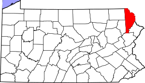 | |
| Townships | ||
| CDPs | ||
| Unincorporated communities | ||
This article is issued from Wikipedia. The text is licensed under Creative Commons - Attribution - Sharealike. Additional terms may apply for the media files.