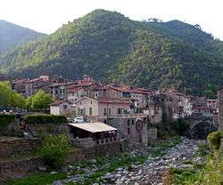
Isolabona
Isolabona (Ligurian: L'Isora[3]) is a comune (municipality) in the Province of Imperia in the Italian region Liguria, located about 120 kilometres (75 mi) southwest of Genoa and about 30 kilometres (19 mi) west of Imperia. As of 2011, it had a population of 716, spread between 333 families throughout an area of 12.4 square kilometres (4.8 sq mi).[4]
Isolabona L'Isora | |
|---|---|
| Comune di Isolabona | |
 | |
Location of Isolabona 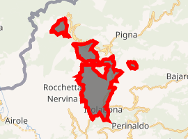
| |
 Isolabona Location of Isolabona in Italy  Isolabona Isolabona (Liguria) | |
| Coordinates: 43°53′N 7°38′E | |
| Country | Italy |
| Region | Liguria |
| Province | Imperia (IM) |
| Area | |
| • Total | 12.4 km2 (4.8 sq mi) |
| Population (Dec. 2004)[2] | |
| • Total | 715 |
| • Density | 58/km2 (150/sq mi) |
| Time zone | UTC+1 (CET) |
| • Summer (DST) | UTC+2 (CEST) |
| Postal code | 18030 |
| Dialing code | 0184 |
Isolabona borders the following municipalities: Apricale, Castelvittorio, Dolceacqua, Pigna and Rocchetta Nervina.
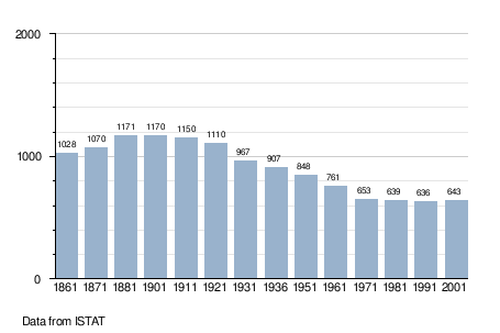
Demographic evolution
gollark: I don't know how people refresh/click so fast.
gollark: Yes, same one as tsiliron, in the coast.
gollark: I saw a copper an hour ago. As is traditional, it vanished fast.
gollark: Basically, the stuff it lists as rare is uncommon.
gollark: Xenowyrms are listed as rare, so...
References
- "Superficie di Comuni Province e Regioni italiane al 9 ottobre 2011". Istat. Retrieved 16 March 2019.
- "Popolazione Residente al 1° Gennaio 2018". Istat. Retrieved 16 March 2019.
- Frisoni, Gaetano (1910–2002). Dizionario Genovese-Italiano e Italiano-Genovese (in Italian). Genova: Nuova Editrice Genovese.CS1 maint: date format (link)
- All demographics and other statistics: Italian statistical institute Istat.
This article is issued from Wikipedia. The text is licensed under Creative Commons - Attribution - Sharealike. Additional terms may apply for the media files.