Islands (regional unit)
The Islands Regional Unit (Greek: Περιφερειακή ενότητα Νήσων, Periphereiaki enotita Nison) is one of the regional units of Greece. It is part of the region of Attica. The regional unit covers the Saronic Islands, a small part of the Peloponnese peninsula, and a few islands off the eastern Peloponnese coast.
Islands Περιφερειακή ενότητα Νήσων | |
|---|---|
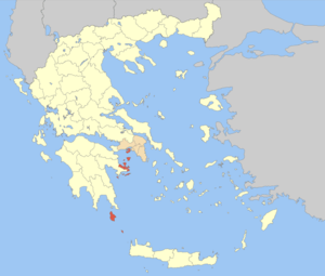 Islands regional unit within Attica | |
| Coordinates: 37°20′N 23°30′E | |
| Country | Greece |
| Region | Attica |
| Area | |
| • Total | 897.6 km2 (346.6 sq mi) |
| Population (2011) | |
| • Total | 74,651 |
| • Density | 83/km2 (220/sq mi) |
| Time zone | UTC+2 |
| • Summer (DST) | UTC+3 (EEST) |
Administration
The regional unit of Islands was created as a part of the 2011 Kallikratis government reform. It is subdivided into 8 municipalities. These are:[1]
gollark: At http://rust-is.cool, obviously.
gollark: r u s t w i k i
gollark: Needs more Rust.
gollark: Yes, I have that app.
gollark: ```glsl#ifdef GL_FRAGMENT_PRECISION_HIGHprecision highp float;#elseprecision mediump float;#endifuniform vec2 resolution;uniform float time;float chunk(float x, float to) { return floor(x / to) * to;}float rescale(float x) { return (x + 1.) / 2.;}void main(void) { vec2 u = gl_FragCoord.xy; vec2 c = vec2( chunk(u.x, 50.), chunk(u.y, 50.) ); vec2 uv = c / resolution.xy; gl_FragColor = vec4( uv, rescale(sin(time)), 1.0 );}```GlsL.
See also
References
Administrative division of the Attica Region | ||
|---|---|---|
| Regional unit of Central Athens | 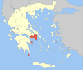 | |
| Regional unit of North Athens | ||
| Regional unit of West Athens | ||
| Regional unit of South Athens | ||
| Regional unit of Piraeus | ||
| Regional unit of East Attica | ||
| Regional unit of West Attica | ||
| Regional unit of Islands | ||
| ||
This article is issued from Wikipedia. The text is licensed under Creative Commons - Attribution - Sharealike. Additional terms may apply for the media files.