Isiolo South Constituency
Isiolo South Constituency is an electoral constituency in Kenya. It is one of two constituencies of Isiolo County. The constituency has nine wards, all electing councillors to the Isiolo County Council. The constituency was established for the 1966 elections.
Isiolo South Constituency | |
|---|---|
Constituency | |
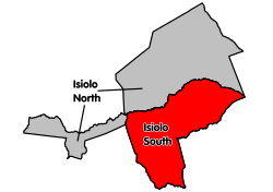
 Location of Isiolo South Constituency in Isiolo County | |
| Area | |
| • Total | 9,817 km2 (3,790 sq mi) |
| Population (2009)[1] | |
| • Total | 43,118 |
| • Density | 4.4/km2 (11/sq mi) |
Members of Parliament
| Elections | MP [2] | Party | Notes |
|---|---|---|---|
| 1966 | Hassan Wario | KANU | |
| 1969 | Adam Wako Bonaya | KANU | One-party system |
| 1974 | Mohamed Ibrahim Ahmed | KANU | One-party system |
| 1979 | Adam Wako Bonaya | KANU | One-party system |
| 1983 | Dida Tullu Jaldessa | KANU | One-party system. |
| 1988 | Dida Tullu Jaldessa | KANU | One-party system. |
| 1992 | Abdillahi Haji Wako | KANU | |
| 1997 | Abdillahi Haji Wako | KANU | |
| 2002 | Abdul Ali | KANU | |
| 2007 | Abdul Ali | KANU |
2013abdullahi banticha jadesa)2017 Abdi koropu tepo
Locations and wards
| Locations | |
| Location | Population* |
|---|---|
| Eldera | 246 |
| Eresa Boru | 3,604 |
| Garba Tulla | 4,368 |
| Garfarsa | 3,233 |
| Kinna | 6,517 |
| Kulamawe | 2,555 |
| Modogashe | 3,467 |
| Malka Daka | 1,418 |
| Rapsu | 106 |
| Sericho | 4,260 |
| Total | x |
| 1999 census.[3] | |
| Wards | |
| Ward | Registered Voters |
|---|---|
| Eresaboru | 997 |
| Garbatula | 1,889 |
| Garfarsa | 1,367 |
| Kinna | 2,453 |
| Kula Mawe | 1,587 |
| Madogashe | 1,320 |
| Malkadaka | 509 |
| Rapsu | 343 |
| Sericho | 1,144 |
| Total | 11,609 |
| *September 2005.[4] | |
gollark: ++eval 1 + 1
gollark: ++search a
gollark: I honestly have no clue why anyone would want this.
gollark: DuckDuckGo "Instant Answers".
gollark: Is there actually any situation where <@509849474647064576> isn't entirely useless?
References
- "Delimitation of Constituencies and Recommendations on Local Authority Electoral Units and Administrative Boundaries for Districts and Other Units" (PDF). Independent Electoral and Boundaries Commission (IEBC). Retrieved 13 May 2019.
- Center for Multiparty Democracy: Politics and Parliamentarians in Kenya 1944–2007 Archived 2008-10-28 at the Wayback Machine
- information.go.ke: CDF allocation by sector and location (2003-6)
- Electoral Commission of Kenya: Registered voters per polling station by electoral area/ward and constituency Archived 2007-09-29 at the Wayback Machine
This article is issued from Wikipedia. The text is licensed under Creative Commons - Attribution - Sharealike. Additional terms may apply for the media files.