Hurricane Max (2017)
Hurricane Max was a short-lived Category 1 hurricane that made landfall in southwestern Mexico, causing minor damage. The sixteenth tropical cyclone, thirteenth named storm, and seventh hurricane of the 2017 Pacific hurricane season, Max developed from a trough of low pressure near the southwestern coast of Mexico on September 13. The storm tracked northeastward under the influence of a mid-level ridge and rapidly strengthened as a result of warm ocean temperatures in its path. Max strengthened into a hurricane on September 14 and peaked as a high-end Category 1 hurricane on the Saffir-Simpson Scale shortly before making landfall in the Mexican state of Guerrero. Rapid weakening ensued as Max moved over the mountainous terrain of Mexico, and it weakened below hurricane strength early on September 15. At 12:00 UTC that day, Max dissipated over the mountains of southern Mexico.
| Category 1 hurricane (SSHWS/NWS) | |
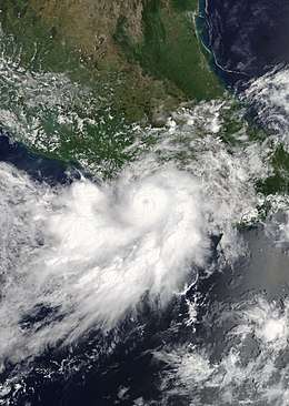 Hurricane Max near peak intensity shortly before landfall in Guerrero on September 14 | |
| Formed | September 13, 2017 |
|---|---|
| Dissipated | September 15, 2017 |
| Highest winds | 1-minute sustained: 90 mph (150 km/h) |
| Lowest pressure | 980 mbar (hPa); 28.94 inHg |
| Fatalities | 1 direct |
| Damage | $76.4 million (2017 USD) |
| Areas affected | Southern Mexico |
| Part of the 2017 Pacific hurricane season | |
The Government of Mexico issued numerous tropical storm and hurricane watches and warnings in anticipation of Max's arrival. Due to the small size of the cyclone, effects were relatively localized and confined to a small area. Regardless, large waves, flooding, mudslides, and sinkholes caused by Max caused moderate damage in the state of Guerrero. Over 1,500 residences suffered flood damage, and numerous roads across the state, including Mexican Federal Highway 200, were closed due to landslides and sinkholes. One death was associated with Max, with another declared missing.
Meteorological history
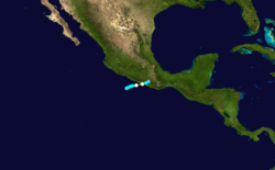
A tropical wave – the same that spawned Hurricane Jose in the Atlantic – crossed Central America and entered the Pacific Ocean on September 11.[1] Vorticity associated with the wave soon became intertwined within a broad cyclonic gyre. On September 13, a large area of convection associated with this system began to organize a few hundred miles southwest of the coast of Mexico. At 12:00 UTC that day, a tropical depression formed 150 miles west-southwest of Acapulco, Mexico.[1] Steered east-northeastward by a mid-level ridge, the depression strengthened into Tropical Storm Max at 18:00 UTC.[1] Located over water temperatures as warm as 30 °C (86 °F), Max rapidly intensified, and it became a hurricane just before 12:00 UTC on September 14.[1] A well-defined eye developed as the small cyclone continued to strengthen, and it reached its peak intensity with maximum sustained winds of 90 mph (150 km/h) shortly before making landfall in Guerrero, Mexico.[1] Once over the mountainous terrain of Mexico, Max rapidly weakened, falling below hurricane strength at 00:00 UTC September 15, and weakening to a tropical depression at 06:00 UTC.[1] The circulation of Max completely dissipated at 12:00 UTC.[1]
Preparations and impact

Upon the classification of Max as a tropical depression, the Government of Mexico issued a tropical storm watch for the southwest coast from Zihuatanejo to Punta Maldonado.[2] At 21:00 UTC, the watch was replaced with a tropical storm warning as Max strengthened into a tropical storm.[3] Six hours later, the Government of Mexico issued a hurricane watch for the same areas to accompany the tropical storm warning as Max continued to intensify.[4] The hurricane watch and tropical storm warning were replaced by a hurricane warning at 12:00 UTC on September 14 as Max strengthened into a hurricane.[5] Three hours later, a tropical storm warning and a hurricane watch were issued for areas east of Punta Maldonado to Lagunas de Chacahua.[6] On September 15, all watches and warnings were discontinued as Max rapidly weakened and moved inland.[7]
In preparation for the storm's arrival, 788 people were evacuated to temporary storm shelters.[8] Torrential rainfall produced by Max caused flooding and mudslides across the entire state of Guerrero, causing damage to over 1,500 homes within the state. In the township of San Marcos, 200 homes were damaged by strong winds and flooding, and one person was reported to have disappeared. While helping to repair a neighbors wall, two residents of the township were swept away by a rapidly-rising river. One of the neighbors survived by holding on to a tree trunk, the other disappeared into the current; his body was later found 1.2 miles (2 kilometers) away.[9][10] Strong winds downed hundreds of trees while sinkholes and mudslides caused many roads to close – including Mexican Federal Highway 200 – which caused travel disruptions across Guerrero and Oaxaca and left numerous travelers stranded.[9] During the storm, telephone service across southwestern Mexico was cut, and 126,503 Comisión Federal de Electricidad customers lost electricity. Access to the town of Juchitán de Zaragoza was severed due to flooded roadways, and a bridge between Cruz Grande and Copala was severely damaged. Across Guerrero, Max hampered communication, destroyed farmland, and left at least 3,000 residents displaced.[9] Offshore and on the coast of Mexico, waves as high as 16 feet (5 meters) caused six fishing vessels to sink.[11] Due to the small size of the hurricane, as well as the sparsely populated nature of the areas it affected, effects were relatively minimal. Total damages from Max are estimated at MX$1.35 billion (US$76.4 million).[12]
See also
- Other tropical cyclones named Max
- Hurricane Boris (1996) - Hurricane of nearly identical intensity that affected similar areas.
- Hurricane Cosme (1989) - Similar, but much larger storm.
- Hurricane Carlotta (2012) - Made landfall in nearby Oaxaca.
References
- Richard J. Pasch (March 29, 2018). Tropical Cyclone Report: Hurricane Max (PDF) (Report). Miami, Florida: National Hurricane Center. Retrieved April 23, 2018.
- Lixion Avila (September 13, 2017). "Tropical Depression Sixteen-E Advisory Number 1". National Hurricane Center. Retrieved May 4, 2018.
- Lixion Avila (September 13, 2017). "Tropical Storm Max Advisory Number 2". National Hurricane Center. Retrieved May 4, 2018.
- Michael Brennan (September 13, 2017). "Tropical Storm Max Advisory Number 3". National Hurricane Center. Retrieved May 4, 2018.
- Robbie Berg (September 14, 2017). "Hurricane Max Special Advisory Number 5". National Hurricane Center. Retrieved May 4, 2018.
- Robbie Berg (September 14, 2017). "Hurricane Max Advisory Number 6". National Hurricane Center. Retrieved May 4, 2018.
- Lixion Avila (September 15, 2017). "Tropical Depression Max Intermediate Advisory Number 8A". National Hurricane Center. Retrieved May 4, 2018.
- "Se degrada huracán Max" (in Spanish). El Mañana. September 16, 2017. Retrieved September 16, 2017.
- "Wind and rain like they had never seen". Mexico News Daily. September 16, 2017. Retrieved September 16, 2017.
- "1 missing, 200 homes damaged after Hurricane Max; Norma strengthens in Pacific". Chicago Tribune. September 16, 2017. Retrieved May 5, 2018.
- "Huracán Max golpea a México: 2 desaparecidos y 600 casas inundadas" (in Spanish). La Gran Época. September 16, 2017. Retrieved September 16, 2017.
- Ezequiel Flores Contreras (September 25, 2017). "Daños por sismo y huracán "Max" en Guerrero ascienden a mil 350 mdp: Astudillo". Proceso. Retrieved September 26, 2018.
Tropical cyclones of the 2017 Pacific hurricane season | ||
|---|---|---|
 | ||
| ||