Hurricane Dolores (2015)
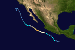
Hurricane Dolores was a strong and moderately damaging tropical cyclone whose remnants brought record-breaking heavy rains and strong winds to California. The fifth tropical depression and second named storm of the record-breaking 2015 Pacific hurricane season, Dolores formed from a tropical wave on July 11. The system gradually strengthened, attaining hurricane status on July 13. Dolores rapidly intensified as it neared the Baja California peninsula, finally peaking as a 130 miles per hour (210 km/h) Category 4 hurricane on the Saffir–Simpson scale. An eyewall replacement cycle began and cooler sea-surface temperatures rapidly weakened the hurricane, and Dolores weakened to a tropical storm two days later. On July 18, Dolores degenerated into a remnant low west of the Baja California peninsula.
| Category 4 major hurricane (SSHWS/NWS) | |
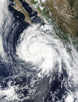 Hurricane Dolores near peak intensity south of the Baja California peninsula. | |
| Formed | July 11, 2015 |
|---|---|
| Dissipated | July 21, 2015 |
| (Remnant low after July 18, 2015) | |
| Highest winds | 1-minute sustained: 130 mph (215 km/h) |
| Lowest pressure | 946 mbar (hPa); 27.94 inHg |
| Fatalities | 1 indirect |
| Damage | $50.477 million (2015 USD) |
| Areas affected | Mexico, California, Southwestern United States |
| Part of the 2015 Pacific hurricane season | |
The proximity of Dolores to Mexico led to Tropical Storm Watches being issued for parts of the coastline. Those were later discontinued as Dolores began tracking westward away from land areas. Hurricane conditions were reported on Socorro Island, and island in the open Pacific that is owned by Mexico. Though the hurricane itself brought minimal damage to the Baja California, its remnants caused major damage to some Californian cities and surrounding areas in the Southwestern United States. Heavy rain caused a bridge on Interstate 10 to collapse and injure one person; a road was washed out on California State Route 78 near the California–Arizona border. One person was killed by a lightning strike. Total damage totaled more than $50 million (in 2015 USD).
Meteorological history
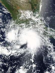
A westward-moving tropical wave crossed Central America and entered the Eastern Pacific on July 8. On July 11, the system was declared Tropical Depression Five-E by the National Hurricane Center (NHC) while located roughly 345 mi (555 km) south-southeast of Acapulco, Mexico. The depression had a considerable amount of deep convection displaced mainly to the north of the center, causing rainbands to affect part of the Mexican coastline.[1] The depression gradually organized, developing banding features around the eastern portion of the system.[2] Late that day, the depression attained tropical storm intensity and received the name Dolores, as a small central dense overcast developed near the low-level center, and a ship near northeastern quadrant reported 35 knots (40 mph) winds.[3][4] Despite environmental conditions that were nearly ideal and largely favorable for strengthening, moderate northwesterly wind shear prevented much intensification. As a result, the storm only gradually strengthened, with tropical storm winds not quite reaching the coast of Southwestern Mexico.[3] The cloud pattern of the storm grew more and more organized throughout July 12, with symmetric and organized convection over the center, causing less impediment from the shear, though outflow remained restricted over the western portion of the system.[5]
Dolores attained hurricane status at 21:00 UTC on July 13 as it turned westward away from the Mexican coastline, with a ragged eye developing as well as more convective banding.[6] As wind shear northwest of the storm began relaxing, spiraling bands began developing over the western portion of the center.[7] Dolores continued to gradually organize and intensify, with dry air entrainments briefly halting intensification. [8] However, soon after, on July 15, Dolores rapidly intensified into a Category 2 hurricane, with the eye becoming more apparent on satellite imagery and very cold cloud tops near the center. Wind shear continued to decreased, with the NHC warning that the system could quickly become a major hurricane.[9] Dolores peaked as a Category 4 hurricane with winds of 130 mph (215 km/h) and a minimum pressure of 946 mbar (hPa; 27.94 inHg) early on July 15. However, as Dolores approached Socorro Island, the cyclone underwent an eyewall replacement cycle and began to steadily weaken. The storm remained potent though as it passed Socorro Island, with an automated weather station on the island recording sustained hurricane-force winds. Despite completing the cycle on July 16, Dolores had moved over cooler sea surface temperatures, and hence continued its weakening trend. By the morning of July 17, Dolores had deteriorated to a tropical storm, and eventually degenerated into a post-tropical remnant low about 300 mi (480 km) west of the Baja California coast the next day. The remnant low slowly curved southwards and dissipated on July 22 well west of San Diego, California.[3][10]
Preparations and Impact
Mexico
Hurricane Dolores skirted of the coast of Mexico for several days after its genesis. Due to the fact that tropical storm-force winds may reach the coast, Tropical Storm Watches were issued for parts of the southwestern coast of Mexico, from Lázaro Cárdenas to Cabo Corrientes. These watches were discontinued on July 13 when Dolores pulled out to sea. [3]
As the eye of Dolores passed around 15 nautical miles northeast of Socorro Island, weather stations on the island recorded hurricane-force sustained winds. One station reported 1-minute sustained winds of 79 mph (128 km/h), with a wind gust of 115 mph (185 km/h). [3]
United States
_rainfall_map.png)
As a tropical cyclone, Dolores produced no impacts in the United States. However, a surge of moisture associated with the remnants of the cyclone moved northward ahead of a trough offshore of the Californian coast between July 17 and 18.[3] The interaction of the moisture with the trough produced very rare July heavy rains over portions of southern and central California. The remnants brought record–breaking rainfall and heavy thunderstorms to Southern California, including major cities such as San Diego and Los Angeles. Record monthly rainfall totals include 1.70 in (43 mm) in San Diego, 1.30 in (33 mm) in Los Angeles, and 1.16 in (29.5 mm) in Paso Robles. In the foothills and mountains of east San Diego County, rainfall exceeded 4 in (100 mm).[11][12] This had the effect of helping firefighters contain the North Fire,[13] but also resulted in debris flows and rock slides that damaged about 90 homes and submerged cars.[3] The San Diego River reached levels of 8.9 ft (2.7 m)—just below flood stage—and overflowed its banks in a few areas.[3]
Flash flooding occurred in Moreno Valley, Perris, and La Mesa, while a microburst occurred in Tierrasanta. A haboob was also recorded in Anza-Borrego Desert State Park.[14] The Los Angeles Angels game against the Boston Red Sox on July 19, 2015, was rained out and had to be postponed. This was the first occurrence of an Angels game being rained out since 1995. [15] Strong winds blew over a semi truck as well as power poles and lines on Interstate 40 near the California-Nevada border, obstructing the road in both directions and causing $75,000 in damage.[16] In Kern County, a 62-year-old man was killed by a lightning strike.[17] A bridge along Interstate 10 near Desert Center was washed out, injuring one. Damage to the bridge was placed at $50 million.[18][19] Another road was washed out by flash flooding, this time along State Route 78 southwest of Cibola, Arizona, with damage totaling $50,000.[20] Hail the size of golf balls was recorded in Bear Valley, Alpine County, damaging a police vehicle.[21] Losses across California reached $50.477 million.[22]
See also
- other storms with the same name
- Hurricane Nora (1997) - affected much of the southwestern United States with heavy rain and flooding
- Hurricane Odile (2014) - affected California and Arizona with heavy rain
References
- "Tropical Depression Five-E Discussion Number 1". nhc.noaa.gov. Retrieved 2020-07-13.
- "Tropical Depression Five-E Discussion Number 2". nhc.noaa.gov. Retrieved 2020-08-13.
- Todd B. Kimberlain (October 27, 2015). Hurricane Dolores (PDF) (Report). Tropical Cyclone Report. Miami, Florida: National Hurricane Center. Retrieved November 11, 2015.
- "Tropical Storm DOLORES Discussion Number 4". nhc.noaa.gov. Retrieved 2020-08-13.
- "Tropical Storm Dolores Discussion Number 9". nhc.noaa.gov. Retrieved 2020-07-14.
- "Hurricane Dolores Discussion Number 10". nhc.noaa.gov. Retrieved 2020-08-14.
- "Hurricane Dolores Discussion Number 12". nhc.noaa.gov. Retrieved 2020-08-14.
- "Hurricane Dolores Discussion Number 14". nhc.noaa.gov. Retrieved 2020-08-14.
- "Hurricane Dolores Discussion Number 15". nhc.noaa.gov. Retrieved 2020-08-14.
- "Hurricane Dolores Recap". The Weather Channel. July 19, 2015. Retrieved August 8, 2015.
- "California Gets 'Super Historic' July Rainfall Thanks to Former Hurricane Dolores; More Rain In the West Into Tuesday (FORECAST)". The Weather Channel. July 20, 2015. Retrieved March 21, 2019.
- Record Event Report. National Weather Service (Report). July 19, 2015. Archived from the original on July 14, 2015.
- Kevin Bryne (July 20, 2015). "Moisture to Help Firefighters Gain Upper Hand on Destructive North Fire Burning in California". Accuweather. Retrieved July 20, 2015.
- California Event Report: Flash Flood. National Weather Service Office in San Diego, California (Report). National Climatic Data Center. 2015. Retrieved May 26, 2015.
- Digiovanna, Mike (July 19, 2015). "Angels' home game against Boston Red Sox is rained out, and that's rare". latimes.com. Retrieved 2020-08-11.
- California Event Report: Thunderstorm Wind. National Weather Service Office in Las Vegas, Nevada (Report). National Climatic Data Center. 2015. Retrieved May 26, 2015.
- California Event Report: Lightning. National Weather Service Office in Hanford, California (Report). National Climatic Data Center. 2015. Retrieved May 5, 2015.
- California Event Report: Flash Flood. National Weather Service Office in Phoenix, Arizona (Report). National Climatic Data Center. 2015. Retrieved December 2, 2015.
- Patrick Edgell; Megan Terlecky; Joe Galli; Bianca Rae (July 19, 2015). "I-10 bridge repair expected to cost $5M". KESQ-TV. Desert Center, California. Retrieved July 19, 2015.
- California Event Report: Flash Flood. National Weather Service Office in Phoenix, Arizona (Report). National Climatic Data Center. 2015. Retrieved May 26, 2015.
- California Event Report: Hail. National Weather Service Office in Sacramento, California (Report). National Climatic Data Center. 2015. Retrieved May 7, 2015.
- California Event Reports: July 17–20, 2015 (Report). National Climatic Data Center. 2015. Retrieved May 7, 2019.
External links
| Wikimedia Commons has media related to Hurricane Dolores (2015). |
Tropical cyclones of the 2015 Pacific hurricane season | ||
|---|---|---|
 | ||
| ||