Hume, Australian Capital Territory
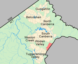
Hume is a suburb of Canberra in the district of Jerrabomberra. The suburb is named after the explorer Hamilton Hume and streets are named after Australian industrialists and businessmen.[2] Hume is a light-industrial suburb and there is no significant housing development. At the 2016 census, Hume had a population of 430,[1] up from six in 2006,[3] as a result of the construction of the Alexander Maconochie Centre. The location of the prison has also given Hume a highly unusual sex ratio with 93.4% of the population being male.[1]
| Hume Canberra, Australian Capital Territory | |||||||||||||||
|---|---|---|---|---|---|---|---|---|---|---|---|---|---|---|---|
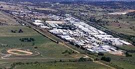 Aerial view | |||||||||||||||
 | |||||||||||||||
| Coordinates | 35°23′13″S 149°10′12″E | ||||||||||||||
| Population | 430 (2016 census)[1] | ||||||||||||||
| • Density | 50.0/km2 (129.5/sq mi) | ||||||||||||||
| Gazetted | 22 March 1982 | ||||||||||||||
| Postcode(s) | 2620 | ||||||||||||||
| Area | 8.6 km2 (3.3 sq mi) | ||||||||||||||
| District | Jerrabomberra | ||||||||||||||
| Territory electorate(s) | Kurrajong | ||||||||||||||
| Federal Division(s) | Bean | ||||||||||||||
| |||||||||||||||
Geology
Deakin Volcanics from the Silurian period underlie Hume. Cream and purple rhyodacite are found in the south and including Tralee, New South Wales. A mixture of purple and green tuff, ashstone, shale, and coarse sandstone is in the north east. Coarse dark purple rhyodacite is in the north end near Queanbeyan turn off.[4]
See also
Footnotes
- Australian Bureau of Statistics (27 June 2017). "Hume (State Suburb)". 2016 Census QuickStats. Retrieved 16 July 2017.

- Canberra's suburb and street names : origins and meanings. Department of the Environment, Land and Planning. 1992. p. 63. ISBN 1-86331-128-9.
- Australian Bureau of Statistics (25 October 2007). "Hume (State Suburb)". 2006 Census QuickStats. Retrieved 24 May 2009.
- Henderson G A M and Matveev G, Geology of Canberra, Queanbeyan and Environs 1:50000 1980.