Huai Rat District
Huai Rat (Thai: ห้วยราช, pronounced [hûa̯j râːt]) is a district (amphoe) of Buriram Province, northeastern Thailand.
Huai Rat ห้วยราช | |
|---|---|
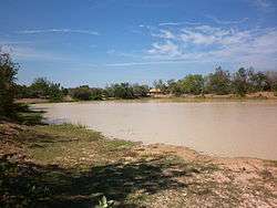 Reservoir Mueang Pho | |
 District location in Buriram Province | |
| Coordinates: 14°57′36″N 103°11′18″E | |
| Country | Thailand |
| Province | Buriram |
| Seat | Huai Rat |
| Area | |
| • Total | 147.1 km2 (56.8 sq mi) |
| Population (2005) | |
| • Total | 35,941 |
| • Density | 244.3/km2 (633/sq mi) |
| Time zone | UTC+7 (ICT) |
| Postal code | 31000 |
| Geocode | 3116 |
Geography
Neighboring districts are (from the east clockwise) Krasang, Mueang Buriram, Ban Dan and Satuek of Buriram Province.
History
The minor district (king amphoe) Huai Rat was created on 1 April 1990, when the five tambons: Huai Rat, Sam Waeng, Ta Sao, Ban Tako, and Sanuan were split off from Mueang Buriram District.[1] It was upgraded to a full district on 8 September 1995.[2]
Administration
The district is divided into eight districts (tambons), which are further subdivided into 85 villages (mubans). Huai Rat is a township (thesaban tambon) which covers parts of tambon Huai Rat and tambon Huai Racha. There are a further seven tambon administrative organizations (TAO).
| No. | Name | Thai name | Villages | Pop. | |
|---|---|---|---|---|---|
| 1. | Huai Rat | ห้วยราช | 15 | 4,439 | |
| 2. | Sam Waeng | สามแวง | 9 | 4,250 | |
| 3. | Ta Sao | ตาเสา | 10 | 4,784 | |
| 4. | Ban Tako | บ้านตะโก | 9 | 3,248 | |
| 5. | Sanuan | สนวน | 12 | 5,334 | |
| 6. | Khok Lek | โคกเหล็ก | 11 | 6,154 | |
| 7. | Mueang Pho | เมืองโพธิ์ | 9 | 3,558 | |
| 8. | Huai Racha | ห้วยราชา | 10 | 4,174 |
References
- ประกาศกระทรวงมหาดไทย เรื่อง แบ่งเขตท้องที่อำเภอเมืองบุรีรัมย์ จังหวัดบุรีรัมย์ ตั้งเป็นกิ่งอำเภอห้วยราช (PDF). Royal Gazette (in Thai). 107 (25 ง): 1353. February 13, 1999.
- พระราชกฤษฎีกาตั้งอำเภอด่านมะขามเตี้ย อำเภอแก่งหางแมว อำเภอภักดีชุมพล อำเภอเวียงแก่น อำเภอแม่วาง อำเภอถ้ำพรรณรา อำเภอบ่อเกลือ อำเภอโนนสุวรรณ อำเภอห้วยราช อำเภอแม่ลาน อำเภอบางแก้ว อำเภอป่าพะยอม อำเภอหนองม่วงไข่ อำเภอยางสีสุราช อำเภอจังหาร อำเภอบ้านธิ อำเภอภูสิงห์ อำเภอบางกล่ำ อำเภอวังม่วง และอำเภอนายูง พ.ศ. ๒๕๓๘ (PDF). Royal Gazette (in Thai). 112 (32 ก): 1–3. August 8, 1995.