Hollenberg, Kansas
Hollenberg is a city in Washington County, Kansas, United States. As of the 2010 census, the city population was 21.[6]
Hollenberg, Kansas | |
|---|---|
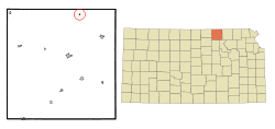 Location within Washington County and Kansas | |
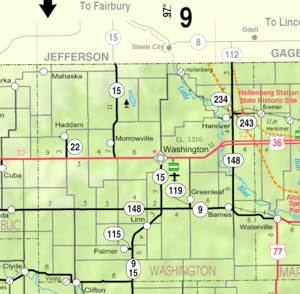 KDOT map of Washington County (legend) | |
| Coordinates: 39°58′52″N 96°59′28″W | |
| Country | United States |
| State | Kansas |
| County | Washington |
| Platted | 1872 |
| Incorporated | 1937 |
| Named for | G.H. Hollenberg |
| Area | |
| • Total | 0.07 sq mi (0.19 km2) |
| • Land | 0.07 sq mi (0.19 km2) |
| • Water | 0.00 sq mi (0.00 km2) |
| Elevation | 1,296 ft (395 m) |
| Population | |
| • Total | 21 |
| • Estimate (2019)[3] | 20 |
| • Density | 273.97/sq mi (105.10/km2) |
| Time zone | UTC-6 (CST) |
| • Summer (DST) | UTC-5 (CDT) |
| ZIP code | 66946 |
| Area code | 785 |
| FIPS code | 20-32650 [4] |
| GNIS ID | 0472648 [5] |
History
Hollenberg was laid out in 1872. It is named for its founder, G. H. Hollenberg, who owned a store at the site.[7]
The first post office in Hollenberg was established in April 1872.[8]
Geography
Hollenberg is located at 39°58′52″N 96°59′28″W (39.981217, -96.991233).[9] According to the United States Census Bureau, the city has a total area of 0.08 square miles (0.21 km2), all of it land.[10] The community is approximately 1.5 miles (2.4 km) south of the Kansas-Nebraska state line.
Demographics
| Historical population | |||
|---|---|---|---|
| Census | Pop. | %± | |
| 1940 | 128 | — | |
| 1950 | 97 | −24.2% | |
| 1960 | 55 | −43.3% | |
| 1970 | 47 | −14.5% | |
| 1980 | 57 | 21.3% | |
| 1990 | 28 | −50.9% | |
| 2000 | 31 | 10.7% | |
| 2010 | 21 | −32.3% | |
| Est. 2019 | 20 | [3] | −4.8% |
| U.S. Decennial Census | |||
2010 census
As of the census[2] of 2010, there were 21 people, 12 households, and 4 families residing in the city. The population density was 262.5 inhabitants per square mile (101.4/km2). There were 23 housing units at an average density of 287.5 per square mile (111.0/km2). The racial makeup of the city was 90.5% White, 4.8% from other races, and 4.8% from two or more races. Hispanic or Latino of any race were 4.8% of the population.
There were 12 households of which 8.3% had children under the age of 18 living with them, 33.3% were married couples living together, and 66.7% were non-families. 50.0% of all households were made up of individuals. The average household size was 1.75 and the average family size was 2.75.
The median age in the city was 55.3 years. 9.5% of residents were under the age of 18; 0.0% were between the ages of 18 and 24; 9.6% were from 25 to 44; 71.4% were from 45 to 64; and 9.5% were 65 years of age or older. The gender makeup of the city was 52.4% male and 47.6% female.
2000 census
As of the census[4] of 2000, there were 31 people, 18 households, and 7 families residing in the city. The population density was 381.5 people per square mile (149.6/km2). There were 28 housing units at an average density of 344.6 per square mile (135.1/km2). The racial makeup of the city was 96.77% White, 3.23% from other races. Hispanic or Latino of any race were 3.23% of the population.
There were 18 households out of which 16.7% had children under the age of 18 living with them, 27.8% were married couples living together, 5.6% had a female householder with no husband present, and 61.1% were non-families. 50.0% of all households were made up of individuals and 11.1% had someone living alone who was 65 years of age or older. The average household size was 1.72 and the average family size was 2.43.
In the city, the population was spread out with 12.9% under the age of 18, 3.2% from 18 to 24, 16.1% from 25 to 44, 48.4% from 45 to 64, and 19.4% who were 65 years of age or older. The median age was 52 years. For every 100 females, there were 106.7 males. For every 100 females age 18 and over, there were 125.0 males.
The median income for a household in the city was $11,667, and the median income for a family was $52,083. Males had a median income of $36,875 versus $16,250 for females. The per capita income for the city was $13,143. There were no families and 14.3% of the population living below the poverty line, including no under eighteens and 100.0% of those over 64.
Education
Hollenberg is served by USD 223 Barnes Hanover Linn.[11]
Hollenberg High School was closed through school unification. The Hollenberg High School mascot was Pirates.
References
- "2019 U.S. Gazetteer Files". United States Census Bureau. Retrieved July 24, 2020.
- "U.S. Census website". United States Census Bureau. Retrieved 2012-07-06.
- "Population and Housing Unit Estimates". United States Census Bureau. May 24, 2020. Retrieved May 27, 2020.
- "U.S. Census website". United States Census Bureau. Retrieved 2008-01-31.
- "US Board on Geographic Names". United States Geological Survey. 2007-10-25. Retrieved 2008-01-31.
- "2010 City Population and Housing Occupancy Status". U.S. Census Bureau. Retrieved November 3, 2011.
- Blackmar, Frank Wilson (1912). Kansas: A Cyclopedia of State History, Embracing Events, Institutions, Industries, Counties, Cities, Towns, Prominent Persons, Etc. Standard Publishing Company. pp. 863.
- "Kansas Post Offices, 1828-1961". Kansas Historical Society. Archived from the original on 9 October 2013. Retrieved 27 June 2014.
- "US Gazetteer files: 2010, 2000, and 1990". United States Census Bureau. 2011-02-12. Retrieved 2011-04-23.
- "US Gazetteer files 2010". United States Census Bureau. Archived from the original on 2012-01-25. Retrieved 2012-07-06.
- "USD 223 Barnes Hanover Linn". USD 223. Retrieved 7 January 2017.
External links
- City
- Schools
- USD 223, local school district
- Maps
- Hollenberg City Map, KDOT
Municipalities and communities of Washington County, Kansas, United States | ||
|---|---|---|
| Cities | 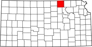 Map of Kansas highlighting Washington County | |
| Unincorporated communities | ||
| Footnotes | ‡This populated place also has portions in an adjacent county or counties | |