Barnes, Kansas
Barnes is a city in Washington County, Kansas, United States. As of the 2010 census, the city population was 159.[6]
Barnes, Kansas | |
|---|---|
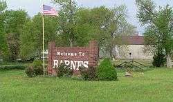 Welcome sign on Kansas Highway 148 | |
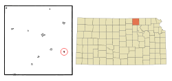 Location within Washington County and Kansas | |
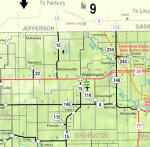 KDOT map of Washington County (legend) | |
| Coordinates: 39°42′41″N 96°52′23″W | |
| Country | United States |
| State | Kansas |
| County | Washington |
| Founded | 1870 (Elm Grove) |
| Incorporated | 1897 |
| Named for | A.S. Barnes |
| Area | |
| • Total | 0.18 sq mi (0.46 km2) |
| • Land | 0.17 sq mi (0.44 km2) |
| • Water | 0.01 sq mi (0.02 km2) |
| Elevation | 1,332 ft (406 m) |
| Population | |
| • Total | 159 |
| • Estimate (2019)[3] | 152 |
| • Density | 894.12/sq mi (345.03/km2) |
| Time zone | UTC-6 (CST) |
| • Summer (DST) | UTC-5 (CDT) |
| ZIP code | 66933 |
| Area code | 785 |
| FIPS code | 20-04250 [4] |
| GNIS ID | 0473152 [5] |
| Website | barnesks.net |
History
Barnes was originally called Elm Grove when it was founded in 1870.[7] It was renamed Barnes in 1876 in honor of A. S. Barnes, a stockholder of the Central Branch Union Pacific Railroad[7][8]
Barnes was a station and shipping point on the Missouri Pacific Railroad.[9]
Geography
Barnes is located at 39°42′41″N 96°52′23″W (39.711525, -96.873094).[10] According to the United States Census Bureau, the city has a total area of 0.18 square miles (0.47 km2), of which, 0.17 square miles (0.44 km2) is land and 0.01 square miles (0.03 km2) is water.[11]
Demographics
| Historical population | |||
|---|---|---|---|
| Census | Pop. | %± | |
| 1880 | 32 | — | |
| 1900 | 383 | — | |
| 1910 | 454 | 18.5% | |
| 1920 | 395 | −13.0% | |
| 1930 | 361 | −8.6% | |
| 1940 | 391 | 8.3% | |
| 1950 | 308 | −21.2% | |
| 1960 | 247 | −19.8% | |
| 1970 | 209 | −15.4% | |
| 1980 | 257 | 23.0% | |
| 1990 | 167 | −35.0% | |
| 2000 | 152 | −9.0% | |
| 2010 | 159 | 4.6% | |
| Est. 2019 | 152 | [3] | −4.4% |
| U.S. Decennial Census | |||
2010 census
As of the census[2] of 2010, there were 159 people, 71 households, and 45 families residing in the city. The population density was 935.3 inhabitants per square mile (361.1/km2). There were 89 housing units at an average density of 523.5 per square mile (202.1/km2). The racial makeup of the city was 95.0% White, 1.3% Native American, and 3.8% from other races. Hispanic or Latino of any race were 5.0% of the population.
There were 71 households, of which 22.5% had children under the age of 18 living with them, 46.5% were married couples living together, 11.3% had a female householder with no husband present, 5.6% had a male householder with no wife present, and 36.6% were non-families. 35.2% of all households were made up of individuals, and 14.1% had someone living alone who was 65 years of age or older. The average household size was 2.24 and the average family size was 2.82.
The median age in the city was 44.2 years. 23.9% of residents were under the age of 18; 5.6% were between the ages of 18 and 24; 22% were from 25 to 44; 27% were from 45 to 64; and 21.4% were 65 years of age or older. The gender makeup of the city was 52.2% male and 47.8% female.
2000 census
As of the census[4] of 2000, there were 152 people, 74 households, and 46 families residing in the city. The population density was 886.2 people per square mile (345.2/km2). There were 99 housing units at an average density of 577.2 per square mile (224.8/km2). The racial makeup of the city was 98.03% White, 0.66% Asian, and 1.32% from two or more races. Hispanic or Latino of any race were 0.66% of the population.
There were 74 households, out of which 14.9% had children under the age of 18 living with them, 56.8% were married couples living together, 4.1% had a female householder with no husband present, and 37.8% were non-families. 37.8% of all households were made up of individuals, and 17.6% had someone living alone who was 65 years of age or older. The average household size was 2.05 and the average family size was 2.67.
In the city, the population was spread out, with 16.4% under the age of 18, 4.6% from 18 to 24, 25.7% from 25 to 44, 19.1% from 45 to 64, and 34.2% who were 65 years of age or older. The median age was 47 years. For every 100 females, there were 87.7 males. For every 100 females age 18 and over, there were 81.4 males.
The median income for a household in the city was $25,682, and the median income for a family was $26,023. Males had a median income of $24,286 versus $18,750 for females. The per capita income for the city was $16,446. About 4.4% of families and 7.3% of the population were below the poverty line, including none of those under the age of eighteen and 4.5% of those 65 or over.
Education
Barnes is served by USD 223 Barnes Hanover Linn.[12]
Barnes schools were closed in 1965 through school unification. The Barnes High School mascot was Bullets.[13]
Notable people
- Omar Knedlik, (1915–1989), inventor of the ICEE frozen drink.
References
- "2019 U.S. Gazetteer Files". United States Census Bureau. Retrieved July 24, 2020.
- "U.S. Census website". United States Census Bureau. Retrieved 2012-07-06.
- "Population and Housing Unit Estimates". United States Census Bureau. May 24, 2020. Retrieved May 27, 2020.
- "U.S. Census website". United States Census Bureau. Retrieved 2008-01-31.
- "US Board on Geographic Names". United States Geological Survey. 2007-10-25. Retrieved 2008-01-31.
- "2010 City Population and Housing Occupancy Status". U.S. Census Bureau. Retrieved November 3, 2011.
- Kansas State Historical Society (1916). Biennial Report of the Board of Directors of the Kansas State Historical Society. Kansas State Printing Plant. pp. 312.
- Rydjord, John (1972). Kansas Place-Names. University of Oklahoma Press, Norman. p. 456. ISBN 0-8061-0994-7.
- Blackmar, Frank Wilson (1912). Kansas: A Cyclopedia of State History, Embracing Events, Institutions, Industries, Counties, Cities, Towns, Prominent Persons, Etc. Standard Publishing Company. pp. 152.
- "US Gazetteer files: 2010, 2000, and 1990". United States Census Bureau. 2011-02-12. Retrieved 2011-04-23.
- "US Gazetteer files 2010". United States Census Bureau. Archived from the original on January 12, 2012. Retrieved 2012-07-06.
- "USD". Retrieved 7 January 2017.
- "Barnes Wins Washington Meet", The Belleville Telescope, 20 February 1941, p.8.
External links
| Wikimedia Commons has media related to Barnes, Kansas. |
- City
- Schools
- USD 223, local school district
- Maps
- Barnes City Map, KDOT
Municipalities and communities of Washington County, Kansas, United States | ||
|---|---|---|
| Cities |  Map of Kansas highlighting Washington County | |
| Unincorporated communities | ||
| Footnotes | ‡This populated place also has portions in an adjacent county or counties | |