Hartland (CDP), Vermont
Hartland is a census-designated place (CDP) that comprises the central village of the town of Hartland, Windsor County, Vermont, United States. As of the 2010 census, the population of the CDP was 380,[3] compared to 3,393 for the entire town of Hartland.
Hartland, Vermont | |
|---|---|
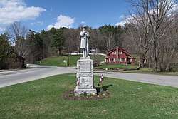 War Memorial | |
_highlighted.svg.png) Location in Windsor County and the state of Vermont. | |
| Coordinates: 43°32′36″N 72°23′56″W | |
| Country | United States |
| State | Vermont |
| County | Windsor |
| Area | |
| • Total | 1.1 sq mi (2.8 km2) |
| • Land | 1.1 sq mi (2.8 km2) |
| • Water | 0.0 sq mi (0.0 km2) |
| Elevation | 587 ft (179 m) |
| Population (2010) | |
| • Total | 380 |
| • Density | 350/sq mi (140/km2) |
| Time zone | UTC-5 (Eastern (EST)) |
| • Summer (DST) | UTC-4 (EDT) |
| ZIP code | 05048 |
| Area code(s) | 802 |
| FIPS code | 50-32350[1] |
| GNIS feature ID | 1457747[2] |
Geography
Hartland is located at the intersection of U.S. Route 5 and Vermont Route 12 in eastern Windsor County. Route 12 travels north to Woodstock, while Route 5 heads north to White River Junction. The two roads travel south in a concurrency to Windsor. Interstate 91 passes east of the village, with access via Exit 9.
gollark: There's a lot of redundant information or space where more could be packed in in most languages, but this is actually good in that it acts as error correction.
gollark: Actually, maybe you could test it by seeing how much of a sentence or whatever you could remove/change before people can't guess the original.
gollark: I don't think so. It would be far too subjective.
gollark: You can look at this site (http://www.projectrho.com/public_html/rocket/spacegunintro.php) for information on somewhat realistic space-weaponry as it applies to sci-fi, though it's kind of oddly organized.
gollark: You wouldn't actually see the beams, for one thing, as far as I know.
References
- "U.S. Census website". United States Census Bureau. Retrieved 2008-01-31.
- "US Board on Geographic Names". United States Geological Survey. 2007-10-25. Retrieved 2008-01-31.
- "Profile of General Population and Housing Characteristics: 2010 Demographic Profile Data (DP-1): Hartland CDP, Vermont". United States Census Bureau. Retrieved August 1, 2012.
Municipalities and communities of Windsor County, Vermont, United States | ||
|---|---|---|
Shire town: Woodstock | ||
| Towns | 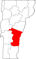 Map of Vermont highlighting Windsor County | |
| Villages | ||
| CDPs | ||
| Other communities | ||
This article is issued from Wikipedia. The text is licensed under Creative Commons - Attribution - Sharealike. Additional terms may apply for the media files.