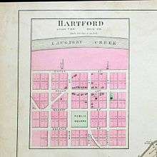
Hartford, Ohio County, Indiana
Hartford is an unincorporated community in Union Township, Ohio County, in the U.S. state of Indiana.[2]
Hartford | |
|---|---|
Unincorporated Community | |
 Hartford  Hartford | |
| Coordinates: 38°59′35″N 84°57′25″W | |
| Country | United States |
| State | Indiana |
| County | Ohio |
| Township | Union |
| Elevation | 502 ft (153 m) |
| Time zone | UTC-6 (Eastern (CST)) |
| • Summer (DST) | UTC-5 (CDT) |
| ZIP code | 47001 |
| Area code(s) | 812, 930 |
| GNIS feature ID | 435824 |

Old Hartford before the flood
History
Hartford was laid out about 1817.[3] In its peak years, Hartford was a point on the stagecoach route from Madison to Aurora.[4] Before the flood of 1937 there were four mills, and a general store which opened up in 1978 and closed in the mid-1980s.
A post office was established at Hartford in 1844, and remained in operation until it was discontinued in 1891.[5]
Geography
Hartford is located at 38°59′35″N 84°57′25″W. Laughtery Creek lies to the north of the community.
gollark: Oh.
gollark: You will totally fear this.
gollark: Fun fact: Minoteaur is gaining file upload capabilities.
gollark: And τ-195H/8G is open to the public, if congested.
gollark: Well, yes, but it's cooler than the 🐝 axis.
References
- "US Board on Geographic Names". United States Geological Survey. October 25, 2007. Retrieved 2016-08-29.
- "Hartford, Ohio County, Indiana". Geographic Names Information System. United States Geological Survey. Retrieved 2016-08-29.
- History of Dearborn and Ohio Counties, Indiana. F. E. Weakley. 1885. pp. 476.
- Best Books on; Federal Writers' Project (1941). Indiana: A Guide to the Hoosier State. Best Books on. p. 375. ISBN 978-1-62376-013-7.
- "Ohio County". Jim Forte Postal History. Retrieved August 29, 2016.
This article is issued from Wikipedia. The text is licensed under Creative Commons - Attribution - Sharealike. Additional terms may apply for the media files.