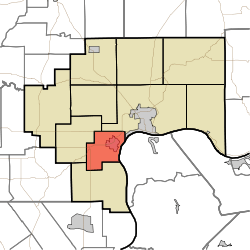
Hanover Township, Jefferson County, Indiana
Hanover Township is one of ten townships in Jefferson County, Indiana, United States. As of the 2010 census, its population was 5,366 and it contained 2,055 housing units.[1]
Hanover Township | |
|---|---|
 Location in Jefferson County | |
| Coordinates: 38°42′13″N 85°29′30″W | |
| Country | United States |
| State | Indiana |
| County | Jefferson |
| Government | |
| • Type | Indiana township |
| Area | |
| • Total | 18.95 sq mi (49.1 km2) |
| • Land | 18.73 sq mi (48.5 km2) |
| • Water | 0.22 sq mi (0.6 km2) 1.16% |
| Elevation | 804 ft (245 m) |
| Population (2010) | |
| • Total | 5,366 |
| • Density | 286.5/sq mi (110.6/km2) |
| GNIS feature ID | 0453370 |
History
Thomas A. Hendricks Library on the campus of Hanover College was listed on the National Register of Historic Places in 1982.[2]
Geography
According to the 2010 census, the township has a total area of 18.95 square miles (49.1 km2), of which 18.73 square miles (48.5 km2) (or 98.84%) is land and 0.22 square miles (0.57 km2) (or 1.16%) is water.[1] The streams of Chain Mill Creek and Happy Valley Creek run through this township.
Cities and towns
Unincorporated towns
Extinct towns
- Antioch Grange
Adjacent townships
- Madison Township (northeast)
- Saluda Township (south)
- Republican Township (west)
Cemeteries
The township contains four cemeteries: Carmel, Greenbriar, Hanover and Old Bethel.
Major highways
gollark: Or at least, there's no guarantee you will get all presses in a finite amount.
gollark: Technically it can take an infinite number of meteorites, even.
gollark: * that you'll get it in two metiorites
gollark: You are not guaranteed two meteorites!
gollark: INCORRECT!
References
- "Hanover Township, Jefferson County, Indiana". Geographic Names Information System. United States Geological Survey. Retrieved 2009-09-24.
- United States Census Bureau cartographic boundary files
- "Population, Housing Units, Area, and Density: 2010 - County -- County Subdivision and Place -- 2010 Census Summary File 1". United States Census. Archived from the original on 2020-02-12. Retrieved 2013-05-10.
- "National Register Information System". National Register of Historic Places. National Park Service. July 9, 2010.
This article is issued from Wikipedia. The text is licensed under Creative Commons - Attribution - Sharealike. Additional terms may apply for the media files.