Indiana State Road 256
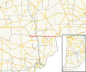
State Road 256 (SR 256) in the U.S. State of Indiana runs mostly through Scott and Jefferson counties, with short portions in Jackson and Washington counties. The western terminus is Indiana 39. The eastern terminus is Indiana 56 near Madison.
| ||||
|---|---|---|---|---|
 | ||||
| Route information | ||||
| Maintained by INDOT | ||||
| Length | 26.832 mi[1] (43.182 km) | |||
| Existed | 1932[2]–present | |||
| Major junctions | ||||
| West end | Old SR 39 | |||
| East end | ||||
| Location | ||||
| Counties | Jackson, Jefferson, Scott, Washington | |||
| Highway system | ||||
| ||||
Route description
SR 256 heads east from its western terminus toward Austin. In Austin SR 256 has an interchange with Interstate 65 and then it has an intersection with U.S. Route 31. After Austin SR 256 has an intersection with State Road 203. Then SR 256 enters Jefferson County, where it has an intersection with State Road 3. Then SR 256 has an intersection with State Road 62 followed by an intersection with State Road 56.[3]
Major intersections
| County | Location | mi[1] | km | Destinations | Notes | |||
|---|---|---|---|---|---|---|---|---|
| Washington | Gibson Township | 0.000 | 0.000 | Old SR 39 | Western terminus of SR 256 | |||
| 0.161 | 0.259 | |||||||
| Jackson |
No major junctions | |||||||
| Scott | Austin | 6.371– 6.610 | 10.253– 10.638 | Exit number 34 on I-65 | ||||
| 7.325 | 11.788 | |||||||
| Johnson Township | 12.564 | 20.220 | Northern terminus of SR 203 | |||||
| Jefferson | Graham Township | 15.562 | 25.045 | |||||
| Madison Township | 26.678 | 42.934 | ||||||
| 26.832 | 43.182 | Eastern terminus of SR 256 | ||||||
| 1.000 mi = 1.609 km; 1.000 km = 0.621 mi | ||||||||
gollark: I don't agree.
gollark: ++remind 6mo <@319753218592866315> 5D macron with multiverse time travel and noneuclidean space.
gollark: <@319753218592866315>
gollark: 5DMWMTT when?
gollark: Can't wait for 5D macron with multiverse time travel.
References
- Indiana Department of Transportation (July 2016). Reference Post Book (PDF). Indianapolis: Indiana Department of Transportation. Retrieved February 2, 2017.
- "Nearly 1,000 Miles of Roads Absorbed". The Franklin Evening Star. April 22, 1932. p. 5. Retrieved August 25, 2016 – via Newspapers.com.

- Google (October 25, 2018). "overview map of SR 256" (Map). Google Maps. Google. Retrieved October 25, 2018.
External links
This article is issued from Wikipedia. The text is licensed under Creative Commons - Attribution - Sharealike. Additional terms may apply for the media files.
