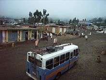
Hagere Selam (Degua Tembien)
Hagere Selam (meaning place of peace) is a town in northern Ethiopia. Located on the Mekelle-Abiy Addi regional road, it is located at an elevation of 2650 metres above sea level. The town is the administrative center of the Dogu'a Tembien woreda. The weekly market is on Saturdays.
Hagere Selam | |
|---|---|
 | |
 Hagere Selam Location within Ethiopia | |
| Coordinates: 13°39′N 39°10′E | |
| Country | Ethiopia |
| Region | Tigray |
| Zone | Mehakelegnaw (Central) |
| Woreda | Degua Tembien |
| Area | |
| • Total | 5.22 km2 (2.02 sq mi) |
| Elevation | 2,625 m (8,612 ft) |
| Population (2007) | |
| • Total | 8,130 |
| • Density | 1,557/km2 (4,030/sq mi) |
| Time zone | UTC+3 (EAT) |
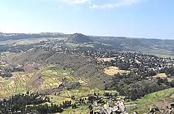
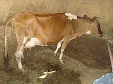
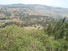
Hagere Selam is located on the saddle point between two of the higher points in Tigray (Imba Zuw'ala and Tsatsen). The regional road from Mekelle to Abiy Addi travels through Hagere Selam, before going down to the Abergele lowlands. The area is categorized as highland or dega. The local economy is dependent on trading, agriculture, with barley being the main crop grown in the area, and on milk production and apiculture.
Demographics
Based on figures from the census in 2007, Hagere Selam had a total population of 8130, of whom 3702 were men and 4428 were women. The 1994 census reported a total population of 3932.[1] The functional agglomeration of Hagere Selam is larger than its administrative boundaries, as urban houses are also built on adjacent land of nearby villages Dingilet, Harena and Melfa.
Water
Given its upper position in the landscape, the town suffers from endemic water shortages. A small reservoir was built at the southern side of the town for sake of irrigation in Addi Selam, but it has been silted up because of erosion during road works.
Siwa and myes
Hagere Selam is known for its mead (myes) and local siwa (beer). Whereas most villages have a limited number of establishments where these drinks can be consumed,[2] they are numerous in Hagere Selam, particularly at the eastern side of the town.
Religion and churches
Almost inhabitants are Orthodox Christians. There are two churches in Hagere Selam: Medhane Alem and Tsion.
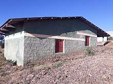
Schools
Almost all children of the town are schooled,[3] though in some schools there is lack of classrooms, directly related to the large intake in primary schools over the last decades.[4] Schools in Hagere Selam include Addi Selam TVET (technical and vocational school) and Hagere Selam High School.
History
The history of Hagere Selam is strongly confounded with the history of Tembien. For a long time, Melfa, west of Hagere Selam, was the capital of Tembien;[5] later on, the administration was established in Abiy Addi as it was easier of access.[6] In 1951, Gebru Gebrehiwot, the new governor, decided to create a new capital of Tembien. First the location of Melfa was chosen. As the inhabitants of Melfa rejected the idea, Hagere Selam was created as a new town. It used already to be an open air market place (hence the name "Idaga Hamus" or Thursday market) – the place was a strategically located mountain saddle,also called "May Aleqti". The new town grew then from the pre-existing settlements May Aleqti and Addi Hailom. In practice, the capital remained in Abiy Addi. It was only after the district of Dogu’a Tembien was created that Hagere Selam started to grow. Basic modern infrastructure (electricity, tap water) came only in the early years 2000.[5] Starting 2016, a new settlement was established in a nearby location called Addi Selam.
Geology
Geological formations
From the higher to the lower locations, the following geological formations are present:[7]
- Phonolite plugs
- Upper basalt

Geomorphology and soils
The Hagere Selam Highlands form a unique geomorphic unit, on the Tertiary volcanic rocks. Corresponding soil types are:[8]
- Associated soil types
- Inclusions
- Rock outcrops and very shallow soils (Lithic Leptosol)
- Rock outcrops and very shallow soils on limestone (Calcaric Leptosol)
- Deep dark cracking clays with very good natural fertility, waterlogged during the wet season (Chromic Vertisol, Pellic Vertisol)
- Shallow stony dark loams on calcaric material (Calcaric Regosol, Calcaric Cambisol)
- Brown loamy soils on basalt with good natural fertility (Luvisol)
Tourism
Its mountainous nature and proximity to Mekelle makes the tabia fit for tourism.[9]
Touristic attractions
- Viewpoints at Ksad Addi Amyuq
- Fortifications of the Derg army on Imba Zuw’ala
- TPLF previous headquarters in caves in neighbouring Mahbere Sillasie
- Open-air museum representing the different nationalities of Ethiopia (under construction)
Geotouristic sites
The high variability of geological formations and the rugged topography invites for geological and geographic tourism or “geotourism”.[10] Most geosites are located in surrounding tabias, but at the outskirts of Hagere Selam one finds:
|
|
Trekking routes
Trekking routes have been established around Hagere Selam, often with a starting point at the outskirts of the town.[11] The tracks are not marked on the ground but can be followed using downloaded .GPX files.[12] Route 1 rounds the town and can serve as an introductory trek before venturing to further places (6 km).
More detailed information
For more details on environment, agriculture, rural sociology, hydrology, ecology, culture, etc., see the overall page on the Dogu’a Tembien district.
References
- Data provided by Woreda Dogu'a Tembien Finance Office
- What do we hear from the farmers in Dogu'a Tembien? [in Tigrinya]. Hagere Selam, Ethiopia. 2016. p. 100.
- Socio-demographic profile, food insecurity and food-aid based response. In: Geo-trekking in Ethiopia's Tropical Mountains - The Dogu'a Tembien District. SpringerNature. 2019. ISBN 978-3-030-04954-6.
- Hartjen, C.A. and Priyadarsini, S., 2012. Denial of Education. In The Global Victimization of Children (pp. 271-321). Springer, Boston, MA. https://link.springer.com/chapter/10.1007/978-1-4614-2179-5_8 .
- Smidt, W (2007). "Mälfa, in: Uhlig S (ed.): Encyclopaedia Aethiopica, Vol 3": 696. Cite journal requires
|journal=(help) - Zervos, A (1936). L'Empire d'Ethiopie, Le Miroir de l'Ethiopie moderne 1906-1935. Alexandria (Egypt): Ecole des Frères.
- Sembroni, A.; Molin, P.; Dramis, F. (2019). Regional geology of the Dogu'a Tembien massif. In: Geo-trekking in Ethiopia's Tropical Mountains - The Dogu'a Tembien District. SpringerNature. ISBN 978-3-030-04954-6.
- Nyssen, Jan; Tielens, Sander; Gebreyohannes, Tesfamichael; Araya, Tigist; Teka, Kassa; Van De Wauw, Johan; Degeyndt, Karen; Descheemaeker, Katrien; Amare, Kassa; Haile, Mitiku; Zenebe, Amanuel; Munro, Neil; Walraevens, Kristine; Gebrehiwot, Kindeya; Poesen, Jean; Frankl, Amaury; Tsegay, Alemtsehay; Deckers, Jozef (2019). "Understanding spatial patterns of soils for sustainable agriculture in northern Ethiopia's tropical mountains". PLoS ONE. 14 (10): e0224041. doi:10.1371/journal.pone.0224041. PMC 6804989. PMID 31639144.
- Geo-trekking in Ethiopia's Tropical Mountains - The Dogu'a Tembien District. SpringerNature. 2019. ISBN 978-3-030-04954-6.
- Miruts Hagos and colleagues (2019). Geosites, Geoheritage, Human-Environment Interactions, and Sustainable Geotourism in Dogu'a Tembien. In: Geo-Trekking in Ethiopia's Tropical Mountains, the Dogu'a Tembien District. SpringerNature. doi:10.1007/978-3-030-04955-3_1. ISBN 978-3-030-04954-6.
- Nyssen, Jan (2019). Description of Trekking Routes in Dogu'a Tembien. GeoGuide. Springer-Nature. pp. 557–675. doi:10.1007/978-3-030-04955-3_38. ISBN 978-3-030-04954-6.
- https://www.openstreetmap.org/traces/tag/nyssen-jacob-frankl
Places adjacent to Hagere Selam (Degua Tembien) | ||||||||||
|---|---|---|---|---|---|---|---|---|---|---|
| ||||||||||