Héry, Nièvre
Héry is a commune in the Nièvre department in central France.
Héry | |
|---|---|
Location of Héry 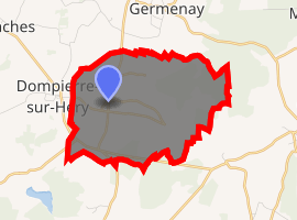
| |
 Héry  Héry | |
| Coordinates: 47°15′50″N 3°34′54″E | |
| Country | France |
| Region | Bourgogne-Franche-Comté |
| Department | Nièvre |
| Arrondissement | Clamecy |
| Canton | Corbigny |
| Intercommunality | Pays Corbigeois |
| Area 1 | 7.72 km2 (2.98 sq mi) |
| Population (2017-01-01)[1] | 74 |
| • Density | 9.6/km2 (25/sq mi) |
| Time zone | UTC+01:00 (CET) |
| • Summer (DST) | UTC+02:00 (CEST) |
| INSEE/Postal code | 58133 /58800 |
| Elevation | 214–321 m (702–1,053 ft) |
| 1 French Land Register data, which excludes lakes, ponds, glaciers > 1 km2 (0.386 sq mi or 247 acres) and river estuaries. | |
Demographics
At the 1999 census, the population was 68. On 1 January 2005, the estimate was 71.
gollark: It's america, so yes.
gollark: On a slightly related note, osmarks.net data harvesting.
gollark: But you're stuck with the bad name for ages and you have to update so much ~~remote configuration~~ paperwork.
gollark: … why is it not working over IPv6
gollark: QUIC established. Safety tends towards 0.
See also
References
| Wikimedia Commons has media related to Héry (Nièvre). |
- "Populations légales 2017". INSEE. Retrieved 6 January 2020.
This article is issued from Wikipedia. The text is licensed under Creative Commons - Attribution - Sharealike. Additional terms may apply for the media files.