Greer, Arizona
Greer is an unincorporated community and census-designated place in Apache County, Arizona, United States. It lies at an elevation of approximately 8,300 feet (2,500 m) in the White Mountains of Arizona, and is surrounded by the Apache-Sitgreaves National Forest. As of the 2010 census it had a population of 41.[3] Greer was founded around 1879 by Mormon settlers from Utah.[4] The Greer post office has the ZIP code of 85927.[5]
Greer, Arizona | |
|---|---|
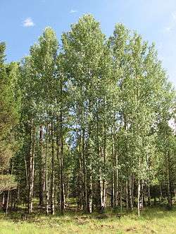
 Aspens in Greer | |
 Greer | |
| Coordinates: 34°00′36″N 109°27′31″W | |
| Country | United States |
| State | Arizona |
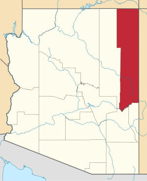
| County | Apache |
| Area | |
| • Total | 0.53 sq mi (1.37 km2) |
| • Land | 0.53 sq mi (1.37 km2) |
| • Water | 0.00 sq mi (0.00 km2) |
| Elevation | 8,356 ft (2,547 m) |
| Population (2010) | |
| • Total | 41 |
| • Estimate (2016)[2] | N/A |
| Time zone | UTC-7 (MST) |
| • Summer (DST) | UTC-6 (MDT) |
| FIPS code | 04-29850 |
| GNIS feature ID | 0029593 |
Geography
Greer is a town located near the towns of Springerville and Eagar in northeast Arizona, near the New Mexico border. Its position in the valley of the Little Colorado River near various lakes means that temperatures are significantly milder than surrounding areas. Sunrise Park Resort, a skiing resort, is located about half an hour's drive west.
While Greer is a four hour drive from Phoenix and a four-and-a-half hour drive from Tucson, it remains one of the most popular summer vacation destinations in Arizona, as it is consistently 20-30 degrees cooler than the deserts.
History
Greer was founded by Mormon Willard Lee and his family in 1879. A small community named Lee Valley gradually developed. The Post Office requested a shorter name, so Greer (after Americus Vespucius Greer, a town planner who had recently moved to the area) was settled on.[6][7]
On June 8, 2011, portions of the east side of town were overrun by the Wallow Fire. While some buildings were destroyed, most of the structures in town remain intact.
Climate
Greer has a humid continental climate (Köppen Dfb) with warm summers coupled with chilly nights and cold, snowy winters.[8]
| Climate data for Greer, Arizona (Station Elevation 8,275ft) | |||||||||||||
|---|---|---|---|---|---|---|---|---|---|---|---|---|---|
| Month | Jan | Feb | Mar | Apr | May | Jun | Jul | Aug | Sep | Oct | Nov | Dec | Year |
| Record high °F (°C) | 65 (18) |
78 (26) |
75 (24) |
74 (23) |
84 (29) |
89 (32) |
90 (32) |
87 (31) |
80 (27) |
77 (25) |
71 (22) |
63 (17) |
90 (32) |
| Average high °F (°C) | 41.7 (5.4) |
43.5 (6.4) |
48.3 (9.1) |
56.1 (13.4) |
65.2 (18.4) |
74.6 (23.7) |
75.6 (24.2) |
72.6 (22.6) |
68.1 (20.1) |
59.9 (15.5) |
50.0 (10.0) |
42.5 (5.8) |
58.2 (14.6) |
| Average low °F (°C) | 15.1 (−9.4) |
17.4 (−8.1) |
21.3 (−5.9) |
26.6 (−3.0) |
33.4 (0.8) |
40.8 (4.9) |
47.3 (8.5) |
46.4 (8.0) |
40.8 (4.9) |
30.9 (−0.6) |
22.7 (−5.2) |
16.2 (−8.8) |
29.9 (−1.2) |
| Record low °F (°C) | −24 (−31) |
−21 (−29) |
−15 (−26) |
−4 (−20) |
8 (−13) |
24 (−4) |
33 (1) |
33 (1) |
20 (−7) |
6 (−14) |
−13 (−25) |
−20 (−29) |
−24 (−31) |
| Average precipitation inches (mm) | 1.54 (39) |
1.44 (37) |
1.53 (39) |
0.84 (21) |
0.70 (18) |
0.84 (21) |
4.25 (108) |
4.39 (112) |
2.08 (53) |
1.77 (45) |
1.22 (31) |
1.76 (45) |
22.35 (568) |
| Average snowfall inches (cm) | 18.7 (47) |
16.7 (42) |
16.3 (41) |
6.1 (15) |
1.3 (3.3) |
0.2 (0.51) |
0 (0) |
0 (0) |
0.1 (0.25) |
2.5 (6.4) |
9.1 (23) |
18.8 (48) |
89.9 (228) |
| Source: The Western Regional Climate Center[9] | |||||||||||||
Government and infrastructure

The United States Postal Service operates the Greer Post Office.[10]
Education
The Apache County Library District operates the Greer Memorial Library.[11]
Attractions
- Apache-Sitgreaves National Forest
Demographics
| Historical population | |||
|---|---|---|---|
| Census | Pop. | %± | |
| U.S. Decennial Census[12] | |||
References
- "2016 U.S. Gazetteer Files". United States Census Bureau. Retrieved Jul 18, 2017.
- "Population and Housing Unit Estimates". Retrieved June 9, 2017.
- "Geographic Identifiers: 2010 Demographic Profile Data (G001): Greer CDP, Arizona". U.S. Census Bureau, American Factfinder. Archived from the original on February 12, 2020. Retrieved April 19, 2013.
- http://www.tucson.com/travel2/arizona/northcentral/articles/stories?id=nc-greer
- Zip Code Lookup
- Byrd H. Granger (1960). Arizona Place Names. University of Arizona Press. p. 12. Retrieved 5 December 2011.
- The Utah Genealogical and Historical Magazine, Volumes 9-10. 1918. p. 184.
- "GREER, ARIZONA - Climate Summary". wrcc.dri.edu. Retrieved 2020-07-21.
- "Seasonal Temperature and Precipitation Information". Western Regional Climate Center. Retrieved April 13, 2013.
- "Post Office™ Location - GREER Archived 2012-08-26 at the Wayback Machine." United States Postal Service. Retrieved on January 30, 2011.
- "Greer Memorial Library Archived 2010-08-22 at the Wayback Machine." Apache County Library District. Retrieved on January 30, 2011.
- "Census of Population and Housing". Census.gov. Retrieved June 4, 2016.
External links
- Greer Community Center
- Business Council of Greer
- GreerAZ.com
- Greer community profile at Arizona Department of Commerce
- Greer photo gallery
