Gmina Osiek, Świętokrzyskie Voivodeship
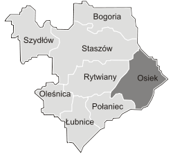
Gmina Osiek[2][3] is an urban-rural gmina (administrative district) in Staszów County, Świętokrzyskie Voivodeship, in south-central Poland. Its seat is the town of Osiek, which lies approximately 21 kilometres (13 mi) east of Staszów and 71 km (44 mi) south-east of the regional capital Kielce.
Gmina Osiek Osiek Commune | |
|---|---|
 Coat of arms | |
 | |
| Coordinates (Osiek): 50°30′56.51″N 21°23′56.45″E | |
| Country | |
| Voivodeship | Świętokrzyskie |
| County | Staszów |
| Seat | Osiek |
| Area (through the years 2006–2010)[1] | |
| • Total | 129.30 km2 (49.92 sq mi) |
| Population (31 December 2010 at Census)[1] | |
| • Total | 7,904 |
| • Density | 61/km2 (160/sq mi) |
| • Urban | 2,001 |
| • Rural | 5,903 |
| Time zone | UTC+1 (CET) |
| • Summer (DST) | UTC+2 (CEST) |
| Postal code | 28-221 |
| Area code(s) | +48 15 |
| Car plates | TSZ |
The gmina covers an area of 129.30 square kilometres (49.9 sq mi), and as of 2010 its total population is ![]()
![]()
![]()
Demography
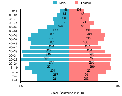
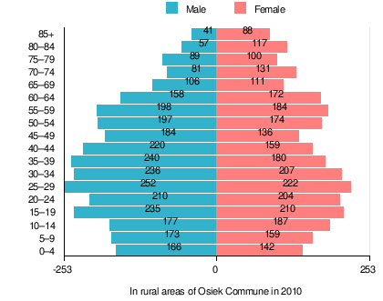
According to the 2011 Poland census, there were 7,904 people residing in Osiek Commune, of whom 50.9% were male and 49.1% were female (out of which the population in rural areas amounts to 5,903, of whom 51.2% were male and 48.8% were female). In the commune, the population was spread out, with 21.2% under the age of 18, 39.3% from 18 to 44, 21.5% from 45 to 64, and 18% who were 65 years of age or older (out of which the population in rural areas amounts to 21.1% under the age of 18, 39.5% from 18 to 44, 20.9% from 45 to 64, and 18.5% who were 65 years of age or older).[1]
Table 1. Population level of commune in 2010 – by age group[1] SPECIFICATION Measure
unitPOPULATION
(by age group in 2010)TOTAL 0–4 5–9 10–14 15–19 20–24 25–29 30–34 35–39 40–44 45–49 50–54 55–59 60–64 65–69 70–74 75–79 80–84 85 + I. TOTAL person 7,904 424 413 505 590 557 625 600 570 492 461 521 510 431 298 273 247 224 163 — of which in % 100 5.4 5.2 6.4 7.5 7 7.9 7.6 7.2 6.2 5.8 6.7 6.5 5.5 3.7 3.5 3.1 2.8 2 1. BY SEX A. Males person 4,020 221 217 254 300 277 334 315 320 270 261 279 261 211 153 102 106 81 58 — of which in % 50.9 2.9 2.8 3.2 3.8 3.5 4.2 4 4 3.4 3.3 3.6 3.3 2.7 1.9 1.3 1.3 1 0.7 B. Females person 3,884 203 196 251 290 280 291 285 250 222 200 242 249 220 145 171 141 143 105 — of which in % 49.1 2.5 2.4 3.2 3.7 3.5 3.7 3.6 3.2 2.8 2.5 3.1 3.2 2.8 1.8 2.2 1.8 1.8 1.3
Table 2. Population level in rural areas in 2010 – by age group[1] SPECIFICATION Measure
unitPOPULATION
(by age group in 2010)TOTAL 0–4 5–9 10–14 15–19 20–24 25–29 30–34 35–39 40–44 45–49 50–54 55–59 60–64 65–69 70–74 75–79 80–84 85 + I. TOTAL person 5,903 308 332 364 445 414 474 443 420 379 320 371 382 330 217 212 189 174 129 — of which in % 100 5.2 5.6 6.2 7.5 7 8 7.5 7.1 6.4 5.4 6.3 6.5 5.6 3.7 3.6 3.2 2.9 2.2 1. BY SEX A. Males person 3,020 166 173 177 235 210 252 236 240 220 184 197 198 158 106 81 89 57 41 — of which in % 51.2 2.8 2.9 3 4 3.6 4.3 4 4.1 3.7 3.1 3.3 3.4 2.7 1.8 1.4 1.5 1 0.7 B. Females person 2,883 142 159 187 210 204 222 207 180 159 136 174 184 172 111 131 100 117 88 — of which in % 48.8 2.4 2.7 3.2 3.6 3.5 3.8 3.5 3 2.7 2.3 2.9 3.1 2.9 1.9 2.2 1.7 2 1.5
Table 3. Population level of commune in 2010 – by sex[1] SPECIFICATION Measure
unitPOPULATION
(by sex in 2010)TOTAL Males Females I. TOTAL person 7,904 4,020 3,884 — of which in % 100 50.9 49.1 1. BY AGE GROUP A. At pre-working age person 1,672 865 807 — of which in % 21.2 11 10.2 B. At working age, grand total person 4,807 2,655 2,152 — of which in % 60.8 33.6 27.2 a. at mobile working age person 3,104 1,643 1,461 — of which in | % 39.3 20.8 18.5 b. at non-mobile working age person 1,703 1,012 691 — of which in | % 21.5 12.8 8.7 C. At post-working age person 1,425 500 925 — of which in % 18 6.3 11.7
Table 4. Population level in rural areas in 2010 – by sex[1] SPECIFICATION Measure
unitPOPULATION
(by sex in 2010)TOTAL Males Females I. TOTAL person 5,903 3,020 2,883 — of which in % 100 51.2 48.8 1. BY AGE GROUP A. At pre-working age person 1,247 650 597 — of which in % 21.1 11 10.1 B. At working age. grand total person 3,563 1,996 1,567 — of which in % 60.4 33.8 26.5 a. at mobile working age person 2,332 1,259 1,073 — of which in | % 39.5 21.3 18.2 b. at non-mobile working age person 1,231 737 494 — of which in | % 20.9 12.5 8.4 C. At post-working age person 1,093 374 719 — of which in % 18.5 6.3 12.2
Villages
Apart from the town of Osiek, Gmina Osiek contains the villages and settlements of Bukowa, Długołęka, Kąty, Łęg, Lipnik, Matiaszów, Mikołajów, Mucharzew, Nakol, Niekrasów, Niekurza, Ossala, Ossala-Lesisko, Pliskowola, Strużki, Suchowola, Sworoń, Szwagrów, Trzcianka, Trzcianka-Kolonia and Tursko Wielkie.
Neighbouring gminas
Gmina Osiek is bordered by the gminas of Baranów Sandomierski, Gawłuszowice, Łoniów, Padew Narodowa, Połaniec, Rytwiany and Staszów.
References
- "Local Data Bank (Bank Danych Lokalnych) – Layout by NTS nomenclature (Układ wg klasyfikacji NTS)". demografia.stat.gov.pl: GUS. 10 March 2011.
- "Osiek – miasto, gmina, powiat staszowski, województwo świętokrzyskie" [Osiek – urban area, commune, Staszów County, Świętokrzyskie Province, Poland]. Topographical map prepared in 1:10,000 scale. Aerial and satellite orthophotomap (in Polish). Head Office of Geodesy and Cartography, Poland, Warsaw. 2011. geoportal.gov.pl. Archived from the original on 21 December 2012. Retrieved 27 April 2011.
- "Osiek – obszar wiejski, gmina, powiat staszowski, województwo świętokrzyskie" [Osiek – rural area, commune, Staszów County, Świętokrzyskie Province, Poland]. Topographical map prepared in 1:10,000 scale. Aerial and satellite orthophotomap (in Polish). Head Office of Geodesy and Cartography, Poland, Warsaw. 2011. geoportal.gov.pl. Archived from the original on 21 December 2012. Retrieved 27 April 2011.


