Gmina Bogoria
Gmina Bogoria[2] is a rural gmina (administrative district) in Staszów County, Świętokrzyskie Voivodeship, in south-central Poland. From 1975–1998 it was part of the former Tarnobrzeg Voivodeship. The gmina seat is the village of Bogoria, which lies approximately 12 kilometres (7 mi) north-east of Staszów and 53 km (33 mi) south-east of the regional capital Kielce.
Gmina Bogoria Bogoria Commune | |
|---|---|
 Coat of arms | |
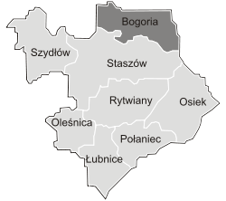
 Location within Staszów County | |
| Coordinates (Bogoria): 50°39′07.32″N 21°16′45.31″E | |
| Country | |
| Voivodeship | Świętokrzyskie |
| County | Staszów |
| Seat | Bogoria |
| Area (through the years 2006-2010)[1] | |
| • Total | 122.89 km2 (47.45 sq mi) |
| Population (31 December 2010 at Census)[1] | |
| • Total | 7,983 |
| • Density | 65/km2 (170/sq mi) |
| Time zone | UTC+1 (CET) |
| • Summer (DST) | UTC+2 (CEST) |
| Postal code | 28-210 |
| Area code(s) | +48 15 |
| Car plates | TSZ |
| Website | http://www.bogoria.pl/ |
The gmina covers an area of 122.89 square kilometres (47.4 sq mi), and as of 2010 its total population is ![]()
Demography
According to the 2011 Poland census, there were 7,983 people residing in Bogoria Commune, of whom 50% were male and 50% were female. In the commune, the population was spread out with 21.9% under the age of 18, 38.3% from 18 to 44, 21.9% from 45 to 64, and 17.8% who were 65 years of age or older.[1]
Table 1. Population level of commune in 2010 — by age group[1] SPECIFICATION Measure
unitPOPULATION
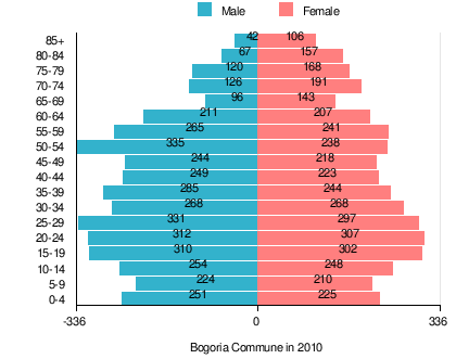
(by age group in 2010)TOTAL 0-4 5-9 10-14 15-19 20-24 25-29 30-34 35-39 40-44 45-49 50-54 55-59 60-64 65-69 70-74 75-79 80-84 85 + I. TOTAL person 7,983 476 434 502 612 619 628 536 529 472 462 573 506 418 239 317 288 224 148 — of which in % 100 6 5.4 6.3 7.7 7.8 7.9 6.7 6.6 5.9 5.8 7.2 6.3 5.2 3 4 3.6 2.8 1.9 1. BY SEX A. Males person 3,990 251 224 254 310 312 331 268 285 249 244 335 265 211 96 126 120 67 42 — of which in % 50 3.1 2.8 3.2 3.9 3.9 4.1 3.4 3.6 3.1 3.1 4.2 3.3 2.6 1.2 1.6 1.5 0.8 0.5 B. Females person 3,993 225 210 248 302 307 297 268 244 223 218 238 241 207 143 191 168 157 106 — of which in % 50 2.8 2.6 3.1 3.8 3.8 3.7 3.4 3.1 2.8 2.7 3 3 2.6 1.8 2.4 2.1 2 1.3
Figure 1. Population pyramid of commune in 2010 — by age group and sex[1]
Table 2. Population level of commune in 2010 — by sex[1] SPECIFICATION Measure
unitPOPULATION
(by sex in 2010)TOTAL Males Females I. TOTAL person 7,983 3,990 3,993 — of which in % 100 50 50 1. BY AGE GROUP A. At pre-working age person 1,749 906 843 — of which in % 21.9 11.3 10.6 B. At working age. grand total person 4,811 2,633 2,178 — of which in % 60.3 33 27.3 a. at mobile working age person 3,059 1,578 1,481 — of which in % 38.3 19.8 18.6 b. at non-mobile working age person 1,752 1,055 697 — of which in % 21.9 13.2 8.7 C. At post-working age person 1,423 451 972 — of which in % 17.8 5.6 12.2
Villages
Gmina Bogoria contains the villages and settlements of Bogoria, Budy, Ceber, Domaradzice, Gorzków, Grzybów, Józefów Witowicki, Jurkowice, Kiełczyna, Kolonia Bogoria, Kolonia Pęcławice, Kolonia Pęcławska, Kolonia Wysoki Małe, Łagówka, Mała Wieś, Malkowice, Miłoszowice, Moszyny, Niedźwiedź, Pęcławice Górne, Pełczyce, Podlesie, Przyborowice, Rosołówka, Szczeglice, Ujazdek, Wagnerówka, Wierzbka, Witowice, Wola Kiełczyńska, Wola Malkowska, Wolica, Wysoki Duże, Wysoki Małe, Wysoki Średnie, Zagorzyce and Zimnowoda.
Neighbouring gminas
Gmina Bogoria is bordered by the gminas of Iwaniska, Klimontów, Raków and Staszów.
References
- "Local Data Bank (Bank Danych Lokalnych) – Layout by NTS nomenclature (Układ wg klasyfikacji NTS)". demografia.stat.gov.pl: GUS. 10 March 2011.
- "Bogoria, gmina, powiat staszowski, województwo świętokrzyskie" [Bogoria, commune, Staszów County, Świętokrzyskie Province, Poland]. Topographical map prepared in 1:10,000 scale. Aerial and satellite orthophotomap (in Polish). Head Office of Geodesy and Cartography, Poland, Warsaw. 2011. geoportal.gov.pl. Archived from the original on 21 December 2012. Retrieved 27 April 2011.

