Gilling West
Gilling West is a village about 3.5 miles (5.6 km) north of Richmond in the Richmondshire district of North Yorkshire, England. It is located in the civil parish of Gilling with Hartforth and Sedbury. It is named "West" to distinguish it from Gilling East in Ryedale, some 32 miles away.
| Gilling West | |
|---|---|
 Gilling West | |
 Gilling West Location within North Yorkshire | |
| Population | 534 (2011 census)[1] |
| OS grid reference | NZ183050 |
| District | |
| Shire county | |
| Region | |
| Country | England |
| Sovereign state | United Kingdom |
| Post town | RICHMOND |
| Postcode district | DL10 |
| Police | North Yorkshire |
| Fire | North Yorkshire |
| Ambulance | Yorkshire |
History
Gilling was mentioned in the Domesday Book of 1086 under the name of Ghellinges. Contrary to the now sleepy nature of the village, it was once a place of some importance in the Anglo-Saxon period of British history. In the 7th century it was a seat of the Deira in the southern region of the Anglian kingdom of Northumbria, and from the 9th century, the surrounding area known as Gillingshire was ruled by the Earls of Mercia, specifically Edwin, who was the last of the Earls to have a seat of power at Gilling before the Norman Conquest saw Edwin's lands given to William the Conqueror's kinsman, Alan Rufus.[2]
St Agatha's Church in the village features a monument to Rear-Admiral Sir Christopher Cradock, who was born in the parish, at Hartforth.[3]
In April 1976, nine-year-old Garry Fridd found a sword in the beck while playing close to the bridge in Gilling. It turned out to be a double-edged, iron-bladed sword with a silver-decorated handle, dating from the 9th century. It is regarded as being amongst the best Anglian weapons ever to be discovered in England. The restored Gilling sword is in the collection of the Yorkshire Museum in York.[4]
The manor house Sedbury Hall is on the edge of the village. Formerly associated with the Darcy, Aske, Conyers and Nevil families,[5] it is now home to the Baker Baker family (formerly of Elemore Hall, Pittington, Co. Durham).[6] The present house was designed by John Carr, and its grounds were laid out in the 18th century by William Sawrey Gilpin.[7]
Governance
The village lies within the Richmond (Yorks) parliamentary constituency, which has been under the control of the Conservative Party for more than a century. The current Member of Parliament, since the 2015 general election, is Rishi Sunak, the constituency's previous incumbent being William Hague. Gilling West also lies within the Richmondshire North electoral division of North Yorkshire County Council and the Gilling West ward of Richmondshire District Council.[8]
Geography
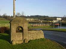
Gilling West is located on the B6274 road that links nearby Richmond with the A66 trunk road and eventually continues on to Staindrop in County Durham. Nearby settlements to Gilling include Hartforth 1.1 miles (1.8 km) north-west, Whashton 2.6 miles (4.2 km) to the west, and the market town of Richmond 3.6 miles (5.8 km) to the south. Gilling Beck flows through the village. Further upstream the same watercourse is known as Hartforth Beck as it passes through the settlement of Hartforth, whilst downstream of Gilling West it becomes Skeeby Beck before its ultimate confluence with the River Swale just west of Brompton-on-Swale. The village is also prone to major flooding.[9]
Demography
For the parish of Gilling with Hartforth and Sedbury:
| Population[10][11][1] | ||||||||||
|---|---|---|---|---|---|---|---|---|---|---|
| Year | 1881 | 1891 | 1901 | 1911 | 1921 | 1931 | 1951 | 1961 | 2001 | 2011 |
| Total | 872 | 754 | 736 | 714 | 721 | 739 | 669 | 665 | 555 | 534 |
In 2015, North Yorkshire County Council estimated the population of the parish to have fallen to 510.[12]
Community and culture
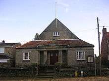
Education for the children of the village is provided by three primary schools in nearby Richmond (CE, Methodist and St Mary's). There was formerly a village school known as Gilling School, built in 1847,[13] but it has since closed and been redeveloped into housing. Pupils receive secondary education at Richmond School & Sixth Form College.[14] The village has two pubs, the Angel Inn and the White Swan, and had a post office/village shop until its closure in 2013.
Religion
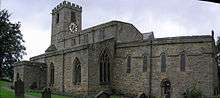
The parish church is dedicated to St Agatha. The Domesday Book records a place of worship in the village as far back as 1086; the current building is thought to be the same one mentioned, restored in the 11th century with minor additions in the 14th century and major alterations in 1845.
Notable people
- Ralph Hedley, painter[15]
References
- UK Census (2011). "Local Area Report – Gilling with Hartforth and Sedbury Parish (E04007486)". Nomis. Office for National Statistics. Retrieved 21 May 2020.
- Village History http://www.gillingwest.org.uk/7.html
- https://www.flickr.com/photos/davewebster14/3164697292/in/set-72157625002677205/
- "Collections Highlights: The Gilling Sword". Yorkshire Museum. Retrieved 5 October 2018.
- "'Parishes: Gilling', in A History of the County of York North Riding: Volume 1, ed. William Page (London, 1914), pp. 71-84". British History Online. Retrieved 15 May 2018.
- "Baker Baker papers: Durham University Archives". JISC Archives Hub. Retrieved 15 May 2018.
- "Sedbury Hall, Richmond, Giling West, near Richmond, North Yorkshire, England". Parks & gardens. Retrieved 15 May 2018.
- Ordnance Survey Open Viewer"Archived copy". Archived from the original on 5 October 2012. Retrieved 14 October 2012.CS1 maint: archived copy as title (link) CS1 maint: BOT: original-url status unknown (link)
- Severe flooding in Gilling West. https://www.standard.co.uk/news/uk/homes-evacuated-as-floods-chaos-hits-uk-8174645.html?action=gallery&ino=18
- "Population at Censuses". Vision of Britain. 2009. Retrieved 12 June 2013.
- UK Census (2001). "Local Area Report – Gilling with Hartforth and Sedbury Parish (36UE047)". Nomis. Office for National Statistics. Retrieved 21 May 2020.
- "2015 Population Estimates Parishes" (PDF). northyorks.gov.uk. December 2016. p. 15. Retrieved 21 May 2020.
- BBC Domesday Reloaded http://www.bbc.co.uk/history/domesday/dblock/GB-416000-504000/page/19
- "Secondary admission arrangements for the Northallerton area". North Yorkshire County Council. Retrieved 17 January 2017.
- Cass, Eddie (2003). "Ralph Hedley and His Sword-Dance Paintings". Folk Music Journal. London: English Folk Dance and Song Society. 8 (3): 335. ISSN 0531-9684.
External links
| Wikimedia Commons has media related to Gilling West. |
- The ancient parish of Gilling West: historical and genealogical information at GENUKI.
- Gilling West Village Website