Gerton, North Carolina
Gerton is an unincorporated community and census-designated place (CDP) in Henderson County, North Carolina, United States. As of the 2010 census it had a population of 254.[3] It is part of the Asheville Metropolitan Statistical Area.
Gerton, North Carolina | |
|---|---|
 Gerton  Gerton | |
| Coordinates: 35°28′45″N 82°20′53″W | |
| Country | United States |
| State | North Carolina |
| County | Henderson County |
| Area | |
| • Total | 3.80 sq mi (9.83 km2) |
| • Land | 3.80 sq mi (9.83 km2) |
| • Water | 0.0 sq mi (0.0 km2) |
| Elevation | 2,671 ft (814 m) |
| Population (2010) | |
| • Total | 254 |
| • Density | 67/sq mi (25.8/km2) |
| Time zone | UTC-5 (Eastern (EST)) |
| • Summer (DST) | UTC-4 (EDT) |
| ZIP code | 28735[1] |
| Area code(s) | 828 |
| GNIS feature ID | 985642[2] |
| FIPS code | 37-25900 |
Geography
The community is located along Gerton Highway (US 74A), 19.7 miles (31.7 km) northeast of Hendersonville, along the banks of Hickory Creek,[4][5] part of the Broad River watershed. It is 17 miles (27 km) southeast of Asheville via US 74A.
According to the U.S. Census Bureau, the Gerton CDP has an area of 3.8 square miles (9.8 km2), all of it recorded as land.[3]
Services
Fire protection is provided by Gerton Fire and Rescue, which has a class 4 DOI rating.
gollark: Oh. Hmm. You probably do need to know that.
gollark: No advice on subject choice since I'm bad at making decisions (I only have to apply *next* year personally so I can put it off).
gollark: It may not be exactly 9% actually but around that sort of figure.
gollark: You do apparently need to apply quite soon, though, unless you wait until next year or something.
gollark: Well, UK student loans are "only" paid back as 9% of your income over £27000 or so, so it actually isn't *that* terrible.
References
- Zip Code Lookup
- "Gerton, North Carolina". Geographic Names Information System. United States Geological Survey. Retrieved 2012-04-30.
- "Geographic Identifiers: 2010 Census Summary File 1 (G001): Gerton CDP, North Carolina". American Factfinder. U.S. Census Bureau. Archived from the original on February 13, 2020. Retrieved December 19, 2017.
- "Hickory Creek". Geographic Names Information System. United States Geological Survey. Retrieved 2012-05-05.
- Google (2012-05-05). "Hendersonville to Gerton" (Map). Google Maps. Google. Retrieved 2012-05-05.
External links
Municipalities and communities of Henderson County, North Carolina, United States | ||
|---|---|---|
| Cities | 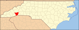 | |
| Towns | ||
| Village | ||
| CDPs | ||
| Unincorporated communities | ||
| Footnotes | ‡This populated place also has portions in an adjacent county or counties | |
This article is issued from Wikipedia. The text is licensed under Creative Commons - Attribution - Sharealike. Additional terms may apply for the media files.