Gawler Chain Trail
The Gawler Chain Trail is a shared use path for cyclists and pedestrians in the inner eastern suburb of Mont Albert in Melbourne, Victoria, Australia.[1][2][3]
| Gawler Chain Trail | |
|---|---|
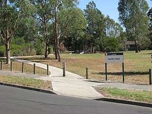 Near Eastern End of the Trail | |
| Length | 2km |
| Location | Melbourne, Victoria, Australia |
| Cycling details | |
| Trail difficulty | Easy |
| Hazards | None |
| Surface | Bitumen, compacted gravel and dirt |
| Hills | Some near western end |
| Water | None |
| Connecting transport | |
| Train(s) | Surrey Hills station |
| Tram(s) | 109 |
The trail has some short road sections and the western section is fairly rough.
Following the Path
The trail starts at the corner of Arnott and Costello Streets. This section consists of a concrete path following an easement. It crosses several quiet streets. The concrete section ends at Strabane Avenue. Head to the right up Strabane Avenue and turn left into Kerry Parade then right into Madang Avenue. At the end, head through the laneway between the houses to Union Road. Turn right and after 100m, turn left into the easement. This part is fairly rough, with only a walking track and some fairly steep, short sections. Continue to the end at the intersection of Greythorn and Belmore Roads.
Connections
Connects via a road section to the Bushy Creek Trail. At the eastern end, proceed down Arnott Street and turn left into Box Hill Crescent. Head past the rear of Koonung Secondary College to the end of the street. Cross Belmore Road and join the Bushy Creek Trail at the children's playground.
West end at 37.803961°S 145.096889°E East end at 37.802461°S 145.113628°E.
References