Gavarnie-Gèdre
Gavarnie-Gèdre is a commune in the department of Hautes-Pyrénées, southwestern France. The municipality was established on 1 January 2016 by merger of the former communes of Gavarnie and Gèdre.[2]
Gavarnie-Gèdre | |
|---|---|
A general view of Gèdre | |
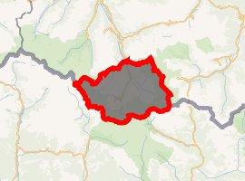
Location of Gavarnie-Gèdre 
| |
 Gavarnie-Gèdre  Gavarnie-Gèdre | |
| Coordinates: 42°47′20″N 0°01′08″E | |
| Country | France |
| Region | Occitanie |
| Department | Hautes-Pyrénées |
| Arrondissement | Argelès-Gazost |
| Canton | La Vallée des Gaves |
| Area 1 | 227.08 km2 (87.68 sq mi) |
| Population (2017-01-01)[1] | 345 |
| • Density | 1.5/km2 (3.9/sq mi) |
| Time zone | UTC+01:00 (CET) |
| • Summer (DST) | UTC+02:00 (CEST) |
| INSEE/Postal code | 65192 /65120 |
| 1 French Land Register data, which excludes lakes, ponds, glaciers > 1 km2 (0.386 sq mi or 247 acres) and river estuaries. | |
Landmarks
The area is famous primarily for the Cirque de Gavarnie, which is a glacial valley. The Spanish-French border lies on the mountains in the commune.[3]
In the village of Gavarnie is a small church. The church, built around the 12th Century, lies on the Camino route. The church contains a cabinet which claims to hold the skulls of a number of the Knights Templar who died whilst traveling to Compostela. The church was an influential factor in the listing of the village of Gavarnie as a UNESCO World Heritage Site.[3] The village is visited by those who ski and by HCPT Pilgrimages to Lourdes.
References
| Wikimedia Commons has media related to Gavarnie-Gèdre (Hautes-Pyrénées). |
- "Populations légales 2017". INSEE. Retrieved 6 January 2020.
- Arrêté préfectoral 18 December 2015 (in French)
- "CIRQUE DE GAVARNIE". Lourdes.