Garrett Township, Douglas County, Illinois
Garrett Township is one of nine townships in Douglas County, Illinois, USA. As of the 2010 census, its population was 1,441 and it contained 613 housing units.[2]
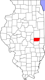
Garrett Township | |
|---|---|
 Location in Douglas County | |
 Douglas County's location in Illinois | |
| Coordinates: 39°49′15″N 88°23′57″W | |
| Country | |
| State | |
| County | Douglas |
| Established | November 5, 1867 |
| Area | |
| • Total | 52.35 sq mi (135.6 km2) |
| • Land | 52.23 sq mi (135.3 km2) |
| • Water | 0.13 sq mi (0.3 km2) 0.25% |
| Elevation | 673 ft (205 m) |
| Population (2010) | |
| • Estimate (2016)[1] | 1,414 |
| • Density | 27.6/sq mi (10.7/km2) |
| Time zone | UTC-6 (CST) |
| • Summer (DST) | UTC-5 (CDT) |
| ZIP codes | 61872, 61911, 61913, 61953 |
| FIPS code | 17-041-28755 |
Geography
According to the 2010 census, the township has a total area of 52.35 square miles (135.6 km2), of which 52.23 square miles (135.3 km2) (or 99.77%) is land and 0.13 square miles (0.34 km2) (or 0.25%) is water.[2]
Unincorporated towns
Cemeteries
The township contains these four cemeteries: Lewis, Lower Lester, Taylor and Upper Lester.
Major highways
Airports and landing strips
- Bragg Landing Strip
- Cooch Landing Area
- Kamm Airport
School districts
- Atwood-Hammond Community Unit School District 39
- Tuscola Community Unit School District 301
Political districts
- State House District 110
- State Senate District 55
gollark: But instead they're actually quite powerful things which run applications written in some weird Java dialect?!
gollark: Which could all be done in Software.
gollark: As far as I can see, all a "SIM card" really needs is some sort of network-ID information, and then an asymmetric keypair to verify itself to a network and act as a user ID.
gollark: I mean, the old model of SIM cards doing a lot made sense in the worse old days when phones were underpowered, but now?
gollark: ... whyyyyyy
References
- "Garrett Township, Douglas County, Illinois". Geographic Names Information System. United States Geological Survey. Retrieved 2010-01-17.
- United States Census Bureau 2009 TIGER/Line Shapefiles
- United States National Atlas
- "Population and Housing Unit Estimates". Retrieved June 9, 2017.
- "Population, Housing Units, Area, and Density: 2010 - County -- County Subdivision and Place -- 2010 Census Summary File 1". United States Census. Archived from the original on 2020-02-12. Retrieved 2013-05-28.
- "Census of Population and Housing". Census.gov. Retrieved June 4, 2016.
External links
Places adjacent to Garrett Township, Douglas County, Illinois | |
|---|---|
Municipalities and communities of Douglas County, Illinois, United States | ||
|---|---|---|
| Cities | Map of Illinois highlighting Douglas County | |
| Villages | ||
| Townships | ||
| Unincorporated communities | ||
| Ghost town | ||
| Footnotes | ‡This populated place also has portions in an adjacent county or counties | |
This article is issued from Wikipedia. The text is licensed under Creative Commons - Attribution - Sharealike. Additional terms may apply for the media files.