Gárdony District
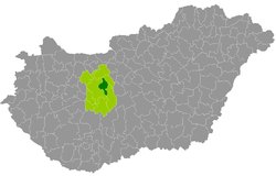
Gárdony (Hungarian: Gárdonyi járás) is a district in central-eastern part of Fejér County. Gárdony is also the name of the town where the district seat is found. The district is located in the Central Transdanubia Statistical Region.
Gárdony District Gárdonyi járás | |
|---|---|
 Coat of arms | |
 Gárdony District within Hungary and Fejér County. | |
| Country | |
| County | Fejér |
| District seat | Gárdony |
| Area | |
| • Total | 306.79 km2 (118.45 sq mi) |
| Area rank | 7th in Fejér |
| Population (2011 census) | |
| • Total | 29,406 |
| • Rank | 5th in Fejér |
| • Density | 96/km2 (250/sq mi) |
Geography
Gárdony District borders with Bicske District to the north, Martonvásár District to the east, Dunaújváros District to the southeast, Székesfehérvár District to the south and west. The number of the inhabited places in Gárdony District is 10.
Municipalities
The district has 2 towns and 8 villages. (ordered by population, as of 1 January 2012)[1]
- Gárdony (9,927) – district seat
- Kápolnásnyék (3,610)
- Nadap (540)
- Pákozd (3,199)
- Pázmánd (2,029)
- Sukoró (1,295)
- Szabadegyháza (2,168)
- Velence (5,359)
- Vereb (786)
- Zichyújfalu (941)
The bolded municipalities are cities.
gollark: You can connect to SPUDNET on any websocket or HTTP-capable platform.
gollark: No it doesn't.
gollark: Linked cards are far inferior to GTech™ SPUDNET™ interlinks.
gollark: I used to have this apart from autocrafting. It was also kind of flaky. It also didn't have great UI.
gollark: Why not?
See also
- List of cities and towns in Hungary
References
This article is issued from Wikipedia. The text is licensed under Creative Commons - Attribution - Sharealike. Additional terms may apply for the media files.