Pákozd
In 1848, the Hungarian army defeated the Croatian army of Josip Jelačić here, in the Battle of Pákozd.[1]
Pákozd | |
|---|---|
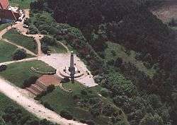 Pákozd, monument from above | |
 Flag  Coat of arms | |
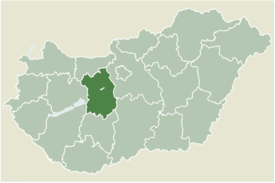 Location of Fejér county in Hungary | |
 Pákozd Location of Pákozd | |
| Coordinates: 47.22112°N 18.54493°E | |
| Country | |
| County | Fejér |
| Area | |
| • Total | 43.32 km2 (16.73 sq mi) |
| Population (2004) | |
| • Total | 2,829 |
| • Density | 65.3/km2 (169/sq mi) |
| Time zone | UTC+1 (CET) |
| • Summer (DST) | UTC+2 (CEST) |
| Postal code | 8095 |
| Area code(s) | 22 |
| Motorways | M7 |
| Distance from Budapest | 54.3 km (33.7 mi) Northeast |
| Website | www |
Gallery
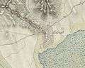 The map of Pákozd from the First Military Mapping Survey of Austria Empire.
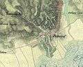 The map of Pákozd from the Second Military Mapping Survey of Austria Empire.
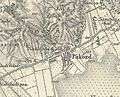 The map of Pákozd from the 3rd Military Mapping Survey of Austria Empire.
gollark: Seriously, NOBODY wants to marry‽
gollark: ++magic sql SELECT * FROM marriages
gollark: AutoBotRobot has the ability to marry things/people.
gollark: oh, that reminds me, anyone want to marry something?
gollark: Do I need an infolaser command?
External links

- Street map (in Hungarian)
| Cities with county rights |
|   |
|---|---|---|
| Towns | ||
| Large villages | ||
| Villages |
| |
| Other topics |
| |
This article is issued from Wikipedia. The text is licensed under Creative Commons - Attribution - Sharealike. Additional terms may apply for the media files.