Pázmánd
Pázmánd | |
|---|---|
 Flag  Coat of arms | |
 Pázmánd Location of Pázmánd | |
| Coordinates: 47.28745°N 18.65425°E | |
| Country | |
| County | Fejér |
| Area | |
| • Total | 27.14 km2 (10.48 sq mi) |
| Population (2004) | |
| • Total | 2,015 |
| • Density | 74.24/km2 (192.3/sq mi) |
| Time zone | UTC+1 (CET) |
| • Summer (DST) | UTC+2 (CEST) |
| Postal code | 2476 |
| Area code(s) | 22 |
| Motorways | M7 |
| Distance from Budapest | 44.6 km (27.7 mi) Northeast |
| Website | www |
Gallery
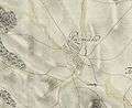 The map of Pázmánd from the First Military Mapping Survey of Austria Empire.
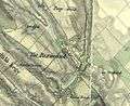 The map of Pázmánd from the Second Military Mapping Survey of Austria Empire.
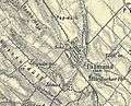 The map of Pázmánd from the 3rd Military Mapping Survey of Austria Empire.
gollark: ĦÆĦÆĦÆĦÆĦÆĦÆĦÆ
gollark: There... isn't, as far as I know, a cure which has been shown to actually work.
gollark: What?
gollark: But then you wouldn't get alerts which are directly relevant to you.
gollark: It's not really.
External links

- Street map (in Hungarian)
| Cities with county rights |
|   |
|---|---|---|
| Towns | ||
| Large villages | ||
| Villages |
| |
| Other topics |
| |
This article is issued from Wikipedia. The text is licensed under Creative Commons - Attribution - Sharealike. Additional terms may apply for the media files.