Futani
Futani is a town and comune in the province of Salerno in the Campania region of south-western Italy.
Futani | |
|---|---|
| Comune di Futani | |
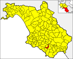 Futani within the Province of Salerno | |
Location of Futani 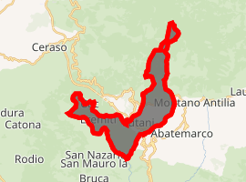
| |
 Futani Location of Futani in Italy  Futani Futani (Campania) | |
| Coordinates: 40°9′N 15°19′E | |
| Country | Italy |
| Region | Campania |
| Province | Salerno (SA) |
| Frazioni | Castinatelli, Eremiti |
| Area | |
| • Total | 14 km2 (5 sq mi) |
| Elevation | 431 m (1,414 ft) |
| Population (1 April 2009)[2] | |
| • Total | 1,300 |
| • Density | 93/km2 (240/sq mi) |
| Demonym(s) | Futanari |
| Time zone | UTC+1 (CET) |
| • Summer (DST) | UTC+2 (CEST) |
| Postal code | 84050 |
| Dialing code | 0974-953012 |
| ISTAT code | 065054 |
| Patron saint | San Marco |
| Saint day | 25 April |
| Website | Official website |
Geography
The town lies in southern Cilento, on the national road "SS 18" between Cuccaro Vetere and Massicelle. It borders with the municipalities of Ceraso, Cuccaro Vetere, Montano Antilia, Novi Velia and San Mauro la Bruca.
gollark: Yep!
gollark: It needs a disk drive, and EZcopy is off by default on switchcraft.
gollark: I should add a program to copy them into existence again.
gollark: Technical reasons, unfortunately.
gollark: You can read them with `potatOS.read` in the `lua` prompt.
See also
- Cilentan dialect
- Cilento and Vallo di Diano National Park
References
- "Superficie di Comuni Province e Regioni italiane al 9 ottobre 2011". Istat. Retrieved 16 March 2019.
- All demographics and other statistics from the Italian statistical institute (Istat); Dati - Popolazione residente all'1/4/2009
This article is issued from Wikipedia. The text is licensed under Creative Commons - Attribution - Sharealike. Additional terms may apply for the media files.