Freeman Township, Pope County, Arkansas
Freeman Township is one of nineteen current townships in Pope County, Arkansas, USA.[1] As of the 2010 census, its unincorporated population was 102.
Freeman Township | |
|---|---|
 Freeman Township Location in Arkansas | |
| Coordinates: 35°39′10″N 93°04′06″W | |
| Country | |
| State | |
| County | Pope |
| Established | 1873 |
| Area | |
| • Total | 119.78 sq mi (310.2 km2) |
| • Land | 119.78 sq mi (310.2 km2) |
| • Water | 0.0 sq mi (0 km2) |
| Elevation | 1,240 ft (380 m) |
| Population (2010) | |
| • Total | 102 |
| • Density | 0.9/sq mi (0.3/km2) |
| Time zone | UTC-6 (CST) |
| • Summer (DST) | UTC-5 (CDT) |
| GNIS feature ID | 69703 |
Geography
According to the United States Census Bureau, Freeman Township covers an area of 119.78 square miles (310.2 km2); all of this land.
gollark: Not that that's very much in big data™ terms.
gollark: I *do* have several thousand pages of crawled web content to train it off now.
gollark: `^(\s*)(([*+-])|(\d+)([).]))(\s*)` ← HIGHLY readable regex in my code.
gollark: I agree, I *need* to be able to call things cryoapioformic.
gollark: It converts words to some highly multidimensional vector based on its connections to other words, via magic.
References
- United States Census Bureau 2008 TIGER/Line Shapefiles
- United States Board on Geographic Names (GNIS)
- United States National Atlas
- "Freeman Township, Pope County, Arkansas." U.S. Census Bureau. Breakdown. Retrieved June 20, 2010.
External links
Municipalities and communities of Pope County, Arkansas, United States | ||
|---|---|---|
| Cities | 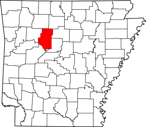 Map of Arkansas highlighting Pope County | |
| Town | ||
| Unincorporated communities |
| |
| Townships | ||
This article is issued from Wikipedia. The text is licensed under Creative Commons - Attribution - Sharealike. Additional terms may apply for the media files.