Frastanz
Frastanz is a market town in the district of Feldkirch in the westernmost Austrian state of Vorarlberg. In earlier times is was known for its production of tobacco.
Frastanz | |
|---|---|
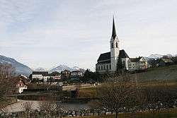
 View of the town | |
 Coat of arms | |
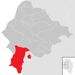
 Location in the district | |
 Frastanz Location within Austria | |
| Coordinates: 47°13′12″N 09°37′12″E | |
| Country | Austria |
| State | Vorarlberg |
| District | Feldkirch |
| Government | |
| • Mayor | Walter Gohm |
| Area | |
| • Total | 32.3 km2 (12.5 sq mi) |
| Elevation | 510 m (1,670 ft) |
| Population (2018-01-01)[2] | |
| • Total | 6,434 |
| • Density | 200/km2 (520/sq mi) |
| Time zone | UTC+1 (CET) |
| • Summer (DST) | UTC+2 (CEST) |
| Postal code | 6820 |
| Area code | 05522 |
| Vehicle registration | FK |
| Website | www.frastanz.at |
Geography
Frastanz is 510 meters above sea level. It is 32.25 square kms in area. 61.2% of the area is wooded.
History
In ancient times, Frastanz was situated on a Roman Road. It was also the site of the Battle of Frastanz in 1499.
Population
| Year | Pop. | ±% |
|---|---|---|
| 1869 | 1,664 | — |
| 1880 | 1,580 | −5.0% |
| 1890 | 1,814 | +14.8% |
| 1900 | 2,021 | +11.4% |
| 1910 | 2,364 | +17.0% |
| 1923 | 2,111 | −10.7% |
| 1934 | 2,572 | +21.8% |
| 1939 | 2,836 | +10.3% |
| 1951 | 3,530 | +24.5% |
| 1961 | 4,221 | +19.6% |
| 1971 | 5,174 | +22.6% |
| 1981 | 5,413 | +4.6% |
| 1991 | 5,881 | +8.6% |
| 2001 | 6,214 | +5.7% |
| 2011 | 6,153 | −1.0% |
Politics
The local council consists of 27 members, with representatives of five political parties: The Austrian People's Party, the Green Party, the Freedom Party of Austria, the Social Democratic Party of Austria, and the Free Citizens' List. The current mayor is Walter Gohm.
gollark: This predates potatOS by 6 years.
gollark: Why did it assume potatOS was a virus?!
gollark: ~play orbital kinetic bombardment
gollark: ~play orbital laser strike
gollark: ~skip
References
- "Dauersiedlungsraum der Gemeinden Politischen Bezirke und Bundesländer - Gebietsstand 1.1.2018". Statistics Austria. Retrieved 10 March 2019.
- "Einwohnerzahl 1.1.2018 nach Gemeinden mit Status, Gebietsstand 1.1.2018". Statistics Austria. Retrieved 9 March 2019.
This article is issued from Wikipedia. The text is licensed under Creative Commons - Attribution - Sharealike. Additional terms may apply for the media files.